Discover the Best Devon Walks and Scenic Routes Across the County
Devon, in southwest England, is one of the most diverse and rewarding counties for outdoor exploration in the UK. From dramatic coastal cliffs and sandy beaches to wild moorland and peaceful river valleys, it offers some of the best walks in the UK for all abilities.
Whether you are planning a short Devon walk, a coastal adventure, or full-day walking routes across Dartmoor, there is something for every level of Devon walking. This guide brings together some of the most scenic routes to help you walk parts of Devon and experience its varied landscapes at their best.
Easy Walks in Devon ( 2 – 5 km)
Totnes Town Trail
Distance: 2.03 km | Duration: 40 Minutes | Terrain: paved streets, urban paths, gentle inclines
This easy 2 km walk explores the historic market town of Totnes, making it a perfect introduction to walking in Devon for visitors interested in heritage and culture.
The route passes key landmarks including the Brutus Stone, Totnes Museum, St Mary’s Church, the Guildhall, the Butterwalk, and Totnes Castle. Narrow medieval streets and independent shops also add to the town’s unique character.
With paved paths throughout, this accessible trail is ideal for visitors wanting to experience Totnes' history in less than an hour. For those wishing to explore further, the walk can also be extended along the scenic River Dart to nearby Dartington
Codden Hill
Distance: 3.75 km | Duration: 1 Hour 25 Minutes | Terrain: hill paths, woodland, open meadows, steep slopes
Codden Hill is a short and rewarding circular walk just outside Barnstaple. At roughly 4 km, the route combines woodland paths, open meadows, and gentle climbs, making it ideal for relaxed Devon walking with excellent views.
The highlight of the walk is the summit of Codden Hill, where a monument marks one of the highest points and panoramic views stretch across the surrounding valleys, the River Taw Estuary, Bishop's Tawton, Barnstaple, and, on clear days, as far as Lundy Island.
Despite its short length, this varied 1-2 hour walk is a steady ascent and peaceful countryside return.
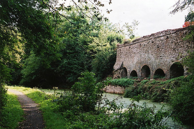
Holcombe Rogus and Grand Western Canal
Distance: 4.77 km | Duration: 1 Hour 25 Minutes | Terrain: farmland, woodland, canal towpath, gentle
This varied circular Devon walk begins in Holcombe Rogus near the Devon–Somerset border. The walk begins beside the Prince of Wales Pub, following a farm track through open farmland and past farm buildings. After crossing a stile, the route continues alongside hedgerows before entering a short wooded section. The path then opens into fields, where a wooden bridge crosses a small stream.
This roughly 5 km circular walk combines farmland, woodland, and canal-side paths with local industrial heritage, making it a varied and enjoyable route through the Devon countryside. Overall, it is a gentle, scenic Devon walk that blends countryside and industrial heritage.
Moderate Walks in Devon (6 – 11 km)
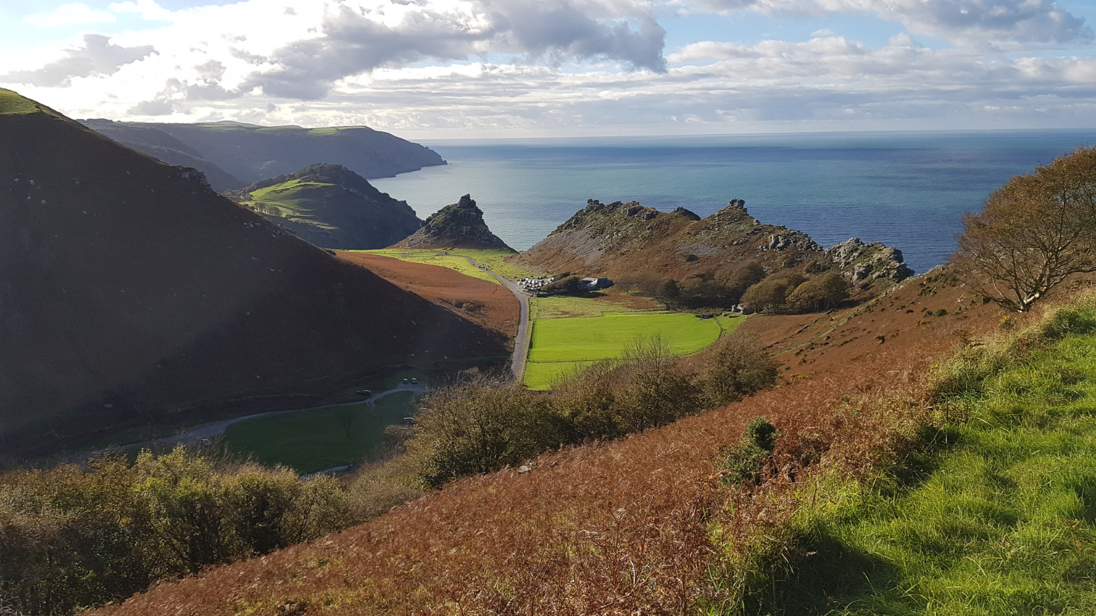
Hollerday Hill, Valley of Rocks and South Cleave from Lynton
Distance: 6.08 km | Duration: 2 Hours 30 Minutes | Terrain: cliffs, ridge, rocky terrain, steep, coastal
This dramatic Devon walk explores some of Exmoor’s most iconic landscapes. Starting in Lynton, the 6 km route climbs to Hollerday Hill, The Valley of Rocks and South Cleave. The route begins going towards Hollerday Hill, passing the site of Hollerday House. As you follow the Valley of Rocks, make sure to take in the roughly 244 m summit for beautiful panoramic views.
Taking around 2-3 hours, this route offers spectacular views of the coast and rugged terrain, and with a chance to witness the wildlife, such as the goats along the cliffs' edge, making it a rather tranquil walk in Devon.
Cornwood via Dendles Wood, High House Waste and East Rook Gate
Distance: 9.94 km | Duration: 3 Hours 45 Minutes | Terrain: woodland, moorland, farmland, riverside
This varied walk explores the edge of Dartmoor, combining ancient woodland, riverside paths, and open moorland. This 10 km circular walk passes through Cornwood to Dendles Wood and takes around 4 hours with moderate climbs through varied terrain.
Once you reach the River Yealm, it opens onto Dartmoor at Dendles Waste and High House Waste. This is a classic example of walks offered in Devon, with both sheltered valleys and exposed moorland views in a single circular route.
It’s a strong choice for variety: dense woodland, high moorland, and rural lanes all in one loop, with a clear sense of ascent and open Dartmoor scenery without being an all-day walk.
Mortehoe, Bull Point and Combesgate Valley from Woolacombe
Distance: 10.65 km | Duration: 3 Hours 55 Minutes | Terrain: cliffs, beaches, valleys, lanes, woodland
Morte and Bull Points, Combesgate valley from Woolacombe is a moderate 10-11 km circular walk that combines rugged coastal cliffs, lighthouse viewpoints, beaches, inland farmland, and a wooded valley finish, with frequent elevation changes throughout.
The route then turns inland towards Mortehoe before descending into Combesgate Valley through woodland paths and sheltered countryside.
At only around 4 hours in length, it’s great for walkers who enjoy the combination of rugged coastline and peaceful inland sections. People who have done this walk have particularly noted it for its outstanding beauty throughout the whole walk, and depending on when you visit, coastal winds with views of the far-off Lundy Island.
Difficult Walks in Devon (10 – 24 km)
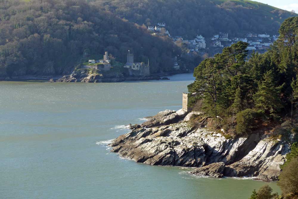
Kingswear to Coleton Fishacre Circular
Distance: 10.46 km | Duration: 4 Hours 05 Minutes | Terrain: cliffs, woodland, estate gardens, lanes, coastal
This demanding Kingswear to Coleton Fishacre combines steep climbs, coastal paths, and woodland tracks along the South Devon coast. At 10.5 km in distance, the circular route begins in Kingswear, taking around 4 hours, with steep climbs, steps, and frequent elevation changes.
The main highlight is the path that follows the dramatic clifftops westwards past Coleton Fishacre gardens, and along narrow, exposed sections towards Froward Point, with constant sea views and WWII coastal defence remains at Inner Froward Point.
It’s a demanding coastal walk, but chosen for its contrast: sheltered subtropical lanes, formal estate landscapes, and rugged cliff paths all in one route, with some of the best South Devon sea views throughout.
Cosdon Hill and Oke Tor from Belstone
Distance: 16.68 km | Duration: 6 Hours 15 Minutes | Terrain: high moorland, tors, ridges, river valley
This walk in Devon explores northern Dartmoor, including Cosdon Hill and Oke Tor. Starting in a small car park on Brenamoor Common, the roughly 17 km Dartmoor circular route from Belstone takes around 6 hours, with strong elevation gain and exposed navigation across high moorland.
The route uses a section of the Tarka Trail and involves significant ascent, exposed navigation, and long ridge walking with minimal shelter.
A classic north Dartmoor tors route, valued for its continuous summit-to-summit walking, long ridge sections, and wide open views, but best suited to clear weather due to limited defined paths across the high moor.
Dartmoor Warren House Inn to Chagford Circular
Distance: 23.79 km | Duration: 8 Hours 25 Minutes | Terrain: moorland, river valleys, farmland, lanes, ridge
This challenging full-day walk explores the heart of Dartmoor National Park, linking Warren House Inn to Chagford for a rewarding 24 km circular route. Taking approximately 8–9 hours to complete, the walk traverses a diverse landscape of open moorland, peaceful river valleys, and quiet country lanes, offering a true sense of Dartmoor's wild and remote character.
Along the way, the route follows sections of the Two Moors Way, passes through historic mining landscapes that reflect the area's industrial heritage, and crosses expansive upland terrain with panoramic views. Combining natural beauty, local history, and varied scenery, this demanding circuit provides an unforgettable experience for well-prepared walkers seeking a full day of adventure in one of England's most iconic national parks.
Dartmoor National Park in Devon
Dartmoor is one of England’s most captivating landscapes, where rugged granite tors, ancient woodlands, winding rivers, and sweeping moorland combine with a rich history of prehistoric sites and local folklore. From gentle family-friendly strolls to demanding walks across remote terrain, the national park offers walking routes for every ability, with spectacular scenery and wildlife around every corner.
For those looking to explore its wildest and most iconic landscapes, Dartmoor Forest is the perfect place to begin. Covering around 227 km² of vast land that was once used as a royal hunting ground, Dartmoor Forest was formed on 1st April 1987 by splitting the parishes of Lydford and Walkhampton, and is the largest parish in Devon.
The area was once a royal hunting forest and remains one of the most important natural landscapes in the UK. It is especially popular for long-distance Devon walking routes, including multi-day trails and historic crossings.
Dartmoor Perambulation explore the national park in depth and provides a history of the land they are walking on. This particular 3-day adventure follows the difficult route of twelve Devonshire Knights in 1240 to check for possible encroachment of the commoners upon the Royal Hunting ground.
The seasons of Devon
Spring is refreshing, with colourful wildflowers blooming, birds singing in the hedgerows, and gentle sunshine warming the green countryside.
Summer, walks are filled with long, sunny days, vibrant fields, coastal breezes, and the scent of wildflowers, making the beaches, cliffs, and moorlands especially inviting.
Autumn brings crisp air, golden and red leaves, misty mornings, and peaceful woodland paths covered in fallen leaves, creating a calm and picturesque atmosphere.
During winter, Devon's landscapes become quieter, with frosty fields, dramatic stormy coastlines, and occasional snowy views on the moors, offering peaceful walks wrapped up against the cold.
Final thoughts on walks in Devon
When you walk in Devon, you are offered some of the most varied and rewarding outdoor experiences in the UK. From coastal cliffs and historic towns to rolling farmland and wild Dartmoor landscapes, there are endless opportunities throughout the year.
Whether you are planning a short walk, exploring countryside trails, or taking on challenging moorland routes, Devon provides something for every ability and interest.
With its mix of scenery, history, and natural beauty, Devon remains one of the best destinations in the UK for walking and unforgettable outdoor adventures.


")


