


Refine your search for walks in Pont-de-Vaux
Pont-de-Vaux walks

 Île de la Motte in Saint-Bénigne
 Local authority
 9.23 mi
 +112 ft
 -112 ft
 4h 20
4h 20
 Moderate
 Departure from Saint-Bénigne (Ain)
On this route, you’ll discover the vast floodplain of the Saône, stretching as far as the eye can see. Once you reach the banks of the Saône, you can see Île de la Motte, which has been designated a Sensitive Natural Area.
Île de la Motte is home to colonies of herons: the little bittern, the little egret and the cattle egret, which can sometimes be sensitive to disturbance during the breeding season. The island’s presence on the river also helps to maintain fish diversity. Sediments carried by the Saône have been deposited and accumulated at La Motte, gradually creating small islets and secondary channels. Together, these form a mosaic of natural habitats that is home to an exceptional diversity of species.Beavers are present on the site and, indeed, contribute to its management by cutting branches from willows and poplars to eat their bark.
The Three Mills Route, starting from the church at Chavannes-sur-Reyssouze
 Visorando Member8.82 mi
+190 ft
-190 ft
4h 15
Moderate
Departure from Chavannes-sur-Reyssouze (Ain)
Visorando Member8.82 mi
+190 ft
-190 ft
4h 15
Moderate
Departure from Chavannes-sur-Reyssouze (Ain)
A route with little elevation gain, offering the chance to explore part of the Reyssouze Valley near Chavannes.
A lush cattle-rearing region in the heart of the Bresse.
La Truchère-Ratenelle Nature Reserve and Site des Charmes
 7.26 mi
+69 ft
-66 ft
3h 25
Moderate
Departure from Sermoyer (Ain)
7.26 mi
+69 ft
-66 ft
3h 25
Moderate
Departure from Sermoyer (Ain)
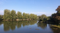
It is undoubtedly the sand dunes that represent the most striking feature of the Nature Reserve. Shaped 5,000 years ago by the wind, these shifting sands are partially covered in mosses and lichens. Only species adapted to arid environments manage to colonise them. Just a few metres from this desert-like environment lies a waterlogged area stretching over 5 to 6 hectares: a wooded peat bog, the presence of which at an altitude of just 200 metres is surprising. A third, very different environment can be seen not far from there: Étang Fouget, whose surrounding marsh takes the form of a vegetative labyrinth and attracts numerous birds.
The Pérouse route in Bâgé-Dommartin
4.13 mi
+66 ft
-72 ft
1h 55
 Easy
Departure from Dommartin (Ain)
Easy
Departure from Dommartin (Ain)
The Pérouse route will allow you to discover an authentic manor house (de la Pérouse) and an old mill alongside which flows the Pérouse leat.
Built in half-timbered style, the manor house dates from the16th century.
The church at Dommartin is notable for having its chancel facing west. The niche above the doorway houses a 15th-century statue of the Virgin and Child.
Around Saint-Maurice-de-Sathonay
 5.37 mi
+295 ft
-295 ft
2h 45
Easy
Departure from Saint-Maurice-de-Satonnay (Saône-et-Loire)
5.37 mi
+295 ft
-295 ft
2h 45
Easy
Departure from Saint-Maurice-de-Satonnay (Saône-et-Loire)
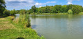
This walk, with its slight incline, is ideal for stretching your legs if you've got a couple of hours to spare.
Romenay's ponds
6.30 mi
+102 ft
-118 ft
3h 00
Easy
Departure from Romenay (Saône-et-Loire)
A route along easy paths in the Bresse region, starting from the traditional village of Romenay.
Route de l'Arboretum in Bâgé-Dommartin
9.27 mi
+141 ft
-141 ft
4h 25
Moderate
Departure from Bâgé-la-Ville (Ain)
Starting from Bâgé-la-Ville town hall. This route allows you to explore the arboretum, passing through market gardeners’ fields and various farms.
The three castles of Sancé
2.88 mi
+66 ft
-66 ft
1h 25
Easy
Departure from Sancé (Saône-et-Loire)
Hike through the heart of the village of Sancé and its surrounding countryside to discover the three castles in the commune: Château du Parc (private), Château de Châtenay (private) and Château Lapalus (communal property).
Circular route from Azé via Charcuble
9.62 mi
+1,125 ft
-1,099 ft
5h 25
Moderate
Departure from Azé (Saône-et-Loire) (Saône-et-Loire)
A lovely walk, mostly in the shade, which will take you to the foot of Mont-Saint-Romain, the highest peak in the Clunisois region, passing through the village of Charcuble, which still bears the mark of our recent history with its chapel. You can visit the Blanot and Azé Caves, or enjoy a swim at the Azé municipal swimming pool, which is open from1 June until the end of August.
Mont Saint-Romain - Blanot - Étang de Crue starting from Azé
11.54 mi
+1,850 ft
-1,854 ft
6h 55
Moderate
Departure from Azé (Saône-et-Loire) (Saône-et-Loire)
From the Azé Caves car park, climb up to Mont Saint-Romain, then take a circular route around Blanot and return via the Étang de Crue. Enjoy a 360° panorama from the roof of the Mont Saint-Romain inn and a beautiful view from the orientation table above the Azé caves.
Route des chapelles et des châteaux à Saint-André-de-Bâgé
 6.08 mi
+105 ft
-135 ft
2h 55
Easy
Departure from Saint-André-de-Bâgé (Ain)
6.08 mi
+105 ft
-135 ft
2h 55
Easy
Departure from Saint-André-de-Bâgé (Ain)
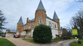
As you wander along the quiet, shaded paths, you’ll encounter a succession of magnificent views and gems of the local heritage, such as the Romanesque church of Saint-André-de-Bâgé, the châteaux of Montépin and La Griffonnière, the remains of the ramparts of Bâgé-le-Châtel, the chapel of Aigrefeuille and beautiful country houses nestled in the valleys.
Route de Fontaine Couverte via the aerodrome
5.11 mi
+66 ft
-69 ft
2h 25
Easy
Departure from Cuisery (Saône-et-Loire)
This circular route allows you to discover all that Cuisery has to offer: the village centre, the aerodrome, the countryside (pond, woods, fields), including wildlife: Bresse poultry farms, horses in the meadows or at the riding school, birds by the pond, and occasionally hares or roe deer in the fields.
From Cuisery to Loisy along the banks of the Seille
5.38 mi
+13 ft
-13 ft
2h 30
Easy
Departure from Cuisery (Saône-et-Loire)
A path linking the Cuisery Water Sports Centre to the Loisy Water Sports Centre along the banks of the Seille. It’s a very pleasant round trip through the countryside and along the riverbank.
Brancion via Mont Prevers and the Bois de la Dame
 5.69 mi
+971 ft
-971 ft
3h 30
Moderate
Departure from Royer (Saône-et-Loire)
5.69 mi
+971 ft
-971 ft
3h 30
Moderate
Departure from Royer (Saône-et-Loire)
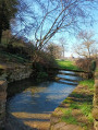
This walk will take you from Royer to Brancion via the Chemin des Moines, at the heart of the Romanesque route linking the abbeys of Tournus and Cluny. Perched on a rocky outcrop, the village of Brancion has been inhabited for 3,000 years. Brancion welcomes you and invites you to discover an idyllic medieval world: a fortified gate, a keep overlooking the village and the Romanesque church, exceptional views and leisurely strolls through a completely pedestrianised area. Nestled in lush greenery, the castle is a place where time seems to have stood still.
Brancion, a small medieval village
 7.54 mi
+1,401 ft
-1,398 ft
4h 40
Moderate
Departure from Royer (Saône-et-Loire)
7.54 mi
+1,401 ft
-1,398 ft
4h 40
Moderate
Departure from Royer (Saône-et-Loire)
Discover Brancion, a small medieval village with a trip to "paradise".
Around the medieval village of Brancion
11.17 mi
+1,394 ft
-1,391 ft
6h 20
Moderate
Departure from Martailly-lès-Brancion (Saône-et-Loire)
Tour of the medieval village of Brancion: Romanesque church and Crusaders’ tombs, covered market hall, feudal castle. Visit the village of Martailly-les-Brancion with its wash house, the source of the Natouze and its fountain, which you reach via the Sentier des Moines (GR®76A).