


Refine your search for walks in Helfaut
Helfaut walks


 Yellow River Trail
 Visorando Member
 2.20 mi
 +213 ft
 -213 ft
 1h 10
1h 10
 Easy
Easy
 Departure from Helfaut (Pas-de-Calais)
A short walk around the La Coupole blockhouse, where forest and magnificent ponds come together.
The Arbre Hardi from Blendecques
 Local authority9.14 mi
+315 ft
-315 ft
4h 30
Local authority9.14 mi
+315 ft
-315 ft
4h 30
 Moderate
Departure from Blendecques (Pas-de-Calais)
Moderate
Departure from Blendecques (Pas-de-Calais)
This route will take you through a variety of landscapes: the Plateau des Landes Regional Nature Reserve and the plain. It is a signposted trail maintained by the Pays de Saint-Omer Urban Community. This trail shares a few kilometres with the Longatte de Blendecques route.
The Wavrans Valley
 7.35 mi
+574 ft
-545 ft
3h 55
Moderate
Departure from Esquerdes (Pas-de-Calais)
7.35 mi
+574 ft
-545 ft
3h 55
Moderate
Departure from Esquerdes (Pas-de-Calais)
The Wavrans-sur-l'Aa nature reserve consists of two hillsides separated by a dry valley, Mont Carrière and Montagne d'Elnes. The chalky slopes of the reserve are steep and unusual for the region. They were also "sculpted" by the bombs of the Second World War.
Circuit d'Ecques par les landes
14.19 mi
+407 ft
-407 ft
6h 50
 Difficult
Departure from Ecques (Pas-de-Calais)
Difficult
Departure from Ecques (Pas-de-Calais)
Leave Ecques via the same route, then take a long, flat walk through the fields to reach Heuringhem. Continue across the moors of Blendecques, Rietz de l'Église and Bibrou before reaching Quiestède via Les Bruyères. Return via the Bois d'Ecques.
The route is relatively flat, but there are a few wet areas (more depending on the weather). During hunting season, avoid Sundays, as some communal woods are rented to hunting clubs!
Route modified and improved in September 2024 to avoid the D 190.
The Fontinettes boat lift
 5.86 mi
+49 ft
-49 ft
2h 45
Easy
Departure from Arques (Pas-de-Calais) (Pas-de-Calais)
5.86 mi
+49 ft
-49 ft
2h 45
Easy
Departure from Arques (Pas-de-Calais) (Pas-de-Calais)
The Sentier des Fontinettes invites you to discover the sometimes unexpected natural treasures of Arques: from the Étang de Beauséjour to the Étang de Malhôve, via the Rihoult Forest and the canal towpath, not forgetting the water sports centre and the boat lift.
Back to the Elnes hillside
14.03 mi
+1,309 ft
-1,283 ft
7h 35
Difficult
Departure from Remilly-Wirquin (Pas-de-Calais)
This place is so beautiful that it deserves a second route.Another good climb with 2 nice climbs and a maximum of paths and trails.
Difficult in dry weather and very difficult in wet weather.
Bois, vallée et coteau de Wavrans-sur-l'Aa
12.32 mi
+761 ft
-745 ft
6h 20
Difficult
Departure from Remilly-Wirquin (Pas-de-Calais)
Another route around the Coteau d’Elnes with very little tarmac. Crossing the Bois d’Esquerdes is even more enjoyable, and the long walk along the riverbank is most pleasant. Finally, the section through the hillside, especially in fine weather, is a real delight (even if it is a bit of a struggle!)
The Pihem Ravine and the Fields of Avroult
16.91 mi
+961 ft
-942 ft
7 hrs
 Very difficult
Departure from Remilly-Wirquin (Pas-de-Calais)
Very difficult
Departure from Remilly-Wirquin (Pas-de-Calais)
Another long route to explore the Ravin de Pihem (the path has been remarkably well maintained: it’s superb in early August 2026). You’ll also follow a superb path at a place called ‘Les Champs d’Avroult’ before popping over to have a look at the old quarries at Cléty.
An easy walk that can be split into two sections.
From the Aa to the Bois d'Esquerdes
13.22 mi
+699 ft
-709 ft
6h 40
Difficult
Departure from Remilly-Wirquin (Pas-de-Calais)
Another long route in this magnificent region.The double crossing of the Bois d’Esquerdes is very pleasant, even if wildlife seems scarce there.Discover the Cartoucherie site.
Route des Batailles in Thérouanne
5.65 mi
+197 ft
-197 ft
2h 45
Easy
Departure from Thérouanne (Pas-de-Calais)
Thérouanne was the capital of the Gallic tribe known as the ‘Morins’. The town was conquered by Julius Caesar. In the Middle Ages, it was the seat of an important bishopric stretching from the Canche to the Yser. It was completely destroyed following the siege by Charles V’s imperial army in 1553, as it was a French enclave.
This trail pays tribute to the three battles that took place at Enguinegatte during the capture of Thérouanne. It is a signposted trail managed by the Pays de Saint-Omer Urban Community.
Hugo Trail in Racquinghem
6.53 mi
+197 ft
-187 ft
3h 10
Easy
Departure from Racquinghem (Pas-de-Calais)
This route will take you through several different types of landscape: the Plateau des Landes regional nature reserve, the plain and the Neuffossé Canal. The latter separates the Pas-de-Calais department from the Nord department.
It is a marked trail maintained by the Pays de Saint-Omer Urban Community.
The Ponds Trail
 3.99 mi
+23 ft
-23 ft
1h 50
Easy
Departure from Mametz (Pas-de-Calais)
3.99 mi
+23 ft
-23 ft
1h 50
Easy
Departure from Mametz (Pas-de-Calais)
A short 6 km walk to explore the Étangs de la Sauvagine in Mametz and the Étangs de Rebecques.
Val de Lys and woods
 13.79 mi
+282 ft
-299 ft
6h 35
Difficult
Departure from Mametz (Pas-de-Calais)
13.79 mi
+282 ft
-299 ft
6h 35
Difficult
Departure from Mametz (Pas-de-Calais)
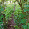
After following the River Lys and passing near the Étangs de Crecques, you’ll cross through two woods before finishing the walk along the paths and small roads of the plain.
A route without any major difficulties, apart from its length. Best undertaken in dry weather.
In wet weather, the two woods are quite tricky and, this winter, the path between Glomenghem and Mametz was flooded (it was fine on 25 April 2024, but the ditches are full to the brim and are just waiting to overflow).
La Cuvette from Clamarais
10.60 mi
+49 ft
-49 ft
4h 55
Moderate
Departure from Clairmarais (Pas-de-Calais)
This route is divided between marshland, bocage and forest. It crosses Flanders before returning to the Audomarois region. In the first part of this itinerary, walkers will see street names in Flemish. This is a signposted trail of the Communauté d'Agglomération du Pays de Saint-Omer.
Ecou marsh “Marais d’Ecou” in Tilques
 6.06 mi
+33 ft
-33 ft
2h 50
Easy
Departure from Tilques (Pas-de-Calais)
6.06 mi
+33 ft
-33 ft
2h 50
Easy
Departure from Tilques (Pas-de-Calais)
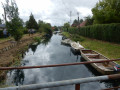
Houses, each with its own dock and boat moored on the Lansberg. People fishing practically from their homes. Cottages, each more beautiful than the last. Little market gardeners' boats loaded with crates of vegetables heading off to who knows where.Truly, the passage along the Lansberg will delight you with its beauty.You'll find a tranquil, picturesque feel that's rare in the region.
Discovering the Audomarois marshlands
 4.26 mi
+7 ft
-10 ft
2h 00
Easy
Departure from Clairmarais (Pas-de-Calais)
4.26 mi
+7 ft
-10 ft
2h 00
Easy
Departure from Clairmarais (Pas-de-Calais)
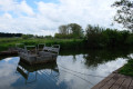
A walk that combines crossing the Clairmarais market garden marsh with the Romelaëre Nature Reserve.Lots of birdwatching: ash herons, coots, storks... And the star attraction of this walk: crossing the canals on the chain ferries, which will appeal to young and old alike!Please note: chain ferries and drawbridges only operate from March 15 to September 5.
The Templars’ Well
 7.18 mi
+157 ft
-171 ft
3h 25
Moderate
Departure from Avroult (Pas-de-Calais)
7.18 mi
+157 ft
-171 ft
3h 25
Moderate
Departure from Avroult (Pas-de-Calais)
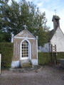
This route is situated on the Artois plateau. The view stretches across the Monts des Flandres. The trail takes its name from a well near the church, dug by the Knights Templar. It is a signposted trail maintained by the Pays de Saint-Omer Urban Community.
Le Lansbergue
 3.65 mi
+23 ft
-23 ft
1h 40
Easy
Departure from Tilques (Pas-de-Calais)
3.65 mi
+23 ft
-23 ft
1h 40
Easy
Departure from Tilques (Pas-de-Calais)
This is a route through the heart of the Audomarois marshes along a marked trail maintained by the Pays de Saint-Omer Urban Community.
From Moringhem to Quelmes
 11.18 mi
+449 ft
-436 ft
5h 30
Moderate
Departure from Moringhem (Pas-de-Calais)
11.18 mi
+449 ft
-436 ft
5h 30
Moderate
Departure from Moringhem (Pas-de-Calais)
A pleasant route, with the chance to enjoy a nice break at the lovely café in Quelmes.
Route amended in August 2026 to take Dominoe’s comments into account. I hope it will be better, but I haven’t been in the area for quite some time.
Hills and valleys in Coyecques
9.64 mi
+991 ft
-991 ft
5h 20
Moderate
Departure from Coyecques (Pas-de-Calais)
From the Lys Valley to Noir Mont and discovery of the hidden valley of Maisnil.
The route is almost entirely off-road, either on good grassy paths or vaguely paved paths.
Do not look for markings, as there are none.
More walks in Helfaut
Select a point of interest below: