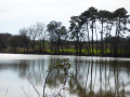
The former gravel pits at Gouts

A pleasant route away from major population centres, winding through maize fields and along the banks of the Adour, where you can explore former gravel pits and a solar farm comprising 23,400 panels with a capacity of 11 Mwc, floating on the body of water created when the gravel pits were abandoned.

Details

n°80645468
Creation:
Last update:
Last review:
–
  • Walking
    Activity: Walking
  • ↔
    Distance: 4.84 mi
  • ◔
    Average duration: 2h 15 
  • ▲
    Difficulty: Easy

  • ⚐
    Back to start: Yes
  • ↗
    Ascent: + 33 ft
  • ↘
    Descent: - 36 ft

  • ▲
    Highest point: 92 ft
  • ▼
    Lowest point: 49 ft

Description of the walk

Route marked ‘Blue Rectangle ’ by the Landes Tourism Committee.
Car park near the church, in the centre of the village.

(S/E) Leave the car park heading south-east, along the small road Rue de Mugron in the heart of the village. After about a hundred metres, turn left onto Rue des Écureuils.

(1) Turn right after the ‘airial’ (a sort of hamlet; see definition below) of Peyron onto the well-cleared track. When you reach the Meysoun property, continue to the Route de Mugron and turn left. Then take the Route d’Estage on the right.

(2) Turn right near the River Adour and the solar farm, opposite the old quarries. Head towards the bank of the River Adour and walk for a long stretch between the river, on your left, and the maize fields.

(3) After passing an area reserved for night-time fishing, turn right onto the track heading north towards the Lamoule airial.

(4) Turn right, cross the small footbridge over the Ruisseau de Marein and head back towards the village via the Route d’Audron. Return to the church car park (S/E).

Waypoints

  1. S/E : mi 0 - alt. 85 ft - Car park near the church
  2. 1 : mi 0.45 - alt. 89 ft - Airial de Peyroun junction
  3. 2 : mi 1.53 - alt. 56 ft - Turn-off towards the solar farm - Adour (fleuve)
  4. 3 : mi 3.74 - alt. 66 ft - ‘Night fishing’ zone - Adour (fleuve)
  5. 4 : mi 4.33 - alt. 85 ft - Junction towards Airial de Lamoule
  6. S/E : mi 4.84 - alt. 82 ft - Car park near the church

Notes

Always bring a hat, water and sun cream.

Please note:

during periods of heavy rain, follow the flood guidelines for the River Adour and wear suitable footwear.

Do not miss point (3) under any circumstances; the banks of the Adour remain passable beyond this point.

Worth a visit

(2) Floating solar panel array.

Airial: a vast, unfenced grassy area shaded by a few pedunculate oaks, Tauzin oaks or umbrella pines, dotted here and there with a few rural dwellings and their outbuildings, set apart from the villages in the Landes de Gascogne.

Reviews and comments

Other walks in the area

For more walks, use our search engine .

The GPS track and description are the property of this route's author. Please do not copy them without permission.