The Chemin des Bois, starting from Arquian

This route is no longer passable. Trees are blocking the paths, and some of these paths are in very poor condition. The signposting put in place a few years ago is no longer up to date. Work will soon be carried out, including a new site survey and new signposting
Arquian is situated in Puisaye Nivernaise; the river Vrille, a tributary of the Loire, flows through the area.
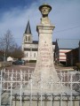
In the village square, the bust of Jean Carriès, sculpted by Charles Gaudry, pays tribute to the famous ceramicist.

Details

n°38533
Creation:
Last update:
Last review:
  • Walking
    Activity: Walking
  • ↔
    Distance: 6.03 mi
  • ◔
    Average duration: 3h 05 
  • ▲
    Difficulty: Easy

  • ⚐
    Back to start: Yes
  • ↗
    Ascent: + 351 ft
  • ↘
    Descent: - 361 ft

  • ▲
    Highest point: 840 ft
  • ▼
    Lowest point: 538 ft

Photos

Description of the walk

(S/E) From the church square, walk down the square to the monument dedicated to Carriès. Turn left, passing the bakery, then the town hall.

(1) Take thefirst road on the left after the town hall towards La Basserie and Montriveaux. Follow the road for over 2 km until you reach the junction at La Pointe, signposted towards Les Terris.

(4) Carry on straight ahead for 400 m until you reach another junction.

Turn right, and after a small pond on the left, you’ll reach a fork signposted for the hamlet of Les Terris.

(4) Take the path on the right which leads into the woods and carry on straight ahead. At the first junction, turn left, then 30 m further on, turn right onto the road leading into the hamlet of Le Lieu du Puits.

(5) Carry on straight ahead to the end of the hamlet, then take the path on the right which runs behind the last farmhouse and follow it to the end of the path at a field entrance. Turn left and follow the path to the end, where it ends at a fenced-off field.

(6) Carry on to the right for 100 metres and take the path on the left which leads into the woods. When you come out of the woods, carry on straight ahead, leaving the path that runs alongside the woods on your right. You’ll reach a crossroads with four paths.

(7) Turn left and follow the path to the hamlet of Les Terris. At the first junction with the road, turn left and continue for about 200 m.

(8) Leave the road and take the path on the right, continuing straight on until the next junction with a road. Take the left-hand road for 200 m until you reach the fork you passed on the way there.

(3) Turn right onto the road and, after 400 m, you’ll reach another fork you passed on the way there.

(2) Turn onto the path leading down to the right. At La Petite Métairie, turn left onto the road leading away from the hamlet for about 200 m.

(10) Take the path on the left, leaving the road on your right. Follow the path until you reach the village of Arquian (S/E).


Waypoints

  1. S/E : mi 0 - alt. 551 ft - Church Square. Near the - La Vrille
  2. 1 : mi 0.2 - alt. 545 ft - Road on the left towards La Basserie
  3. 2 : mi 0.78 - alt. 755 ft - A/R junction
  4. 3 : mi 0.98 - alt. 768 ft - Crossroads at the end of the circular loop
  5. 4 : mi 1.63 - alt. 801 ft - Path on the right
  6. 5 : mi 2.2 - alt. 784 ft - Le Lieu du Puits
  7. 6 : mi 2.86 - alt. 833 ft - Path on the right
  8. 7 : mi 3.49 - alt. 817 ft - Path on the left
  9. 8 : mi 4.12 - alt. 778 ft - Path on the right
  10. 9 : mi 4.98 - alt. 755 ft - Path on the right
  11. 10 : mi 5.37 - alt. 630 ft - Path on the left
  12. S/E : mi 6.03 - alt. 551 ft - Church Square

Notes

This walk will soon be updated with better signposting and a site survey

Winter 2021: route not accessible.

Reviews and comments

3.4 / 5
Based on 3 reviews

Reliability of the description
3 / 5
Ease of following the route
2.7 / 5
Route interest
4.7 / 5
User 12101469

Overall rating : 3.7 / 5

Date of your route : Sep 14, 2026
Reliability of the description : ★★★★☆ Good
Ease of following the route : ★★★☆☆ Average
Route interest : ★★★★☆ Good
Very busy route : No

The path is well signposted, but you’ll need to use your judgement at one or two junctions
This easy walk is in the shade, which is very pleasant in hot weather

Machine-translated

User 6780902

Hike done this morning. Markings well updated No. 37. Very pleasant. However, some markings are missing at two important crossroads. Path now passable again. 10 km.
A few trees across the path, but that's the same everywhere, I'd say.
It's a good idea to use the app. Despite the new markings, the map is fairly accurate.
Thank you for this lovely route.
Mireille, Saint-Fargeau

Machine-translated

Orando974
Orando974 ★

Hello,

Following discussions with the tourist office, this walk will soon be surveyed and signposted. It will be updated once the survey has been completed.

Have a nice day,

Orando974

Machine-translated

OT Puisaye-Forterre
OT Puisaye-Forterre

Hello Lncd,

Thank you for your feedback.

Your message has been forwarded to the organisation responsible for signposting.

It’s true that, in this wet weather, some of the paths in Puisaye can get very muddy.

Please feel free to visit our website: www.puisaye-tourisme.fr to find other ideas for outings and walks.

Kind regards,

Machine-translated

Lncd
Lncd

Overall rating : 2.7 / 5

Date of your route : Jan 04, 2021
Reliability of the description : ★★☆☆☆ Disappointing
Ease of following the route : ★☆☆☆☆ Very disappointing
Route interest : ★★★★★ Very good
Very busy route : No

We weren’t able to complete the whole walk due to a lack of signposting, and we didn’t have a map with us. What’s more, a resident of the hamlet of Les Terris advised us not to carry on, as the path was impassable due to the rain over the previous few days.
That said, we really enjoyed discovering the few potters we came across along the way and the beautiful scenery. Looking at the route description again, it looks like it could be a lovely walk. In any case, thank you for all your hard work; we really appreciate this website.

Machine-translated

POULIN Gérard
POULIN Gérard ★

Hello, anned, and thank you for your constructive feedback.
I think this route is going to be revised and enhanced with WPT by the OTPN in the coming weeks.
It’s true that this route is well worth exploring – as are many others in this natural area.

Machine-translated

anned
anned
• Edited:

Overall rating : 4 / 5

Date of your route : Dec 28, 2014
Reliability of the description : ★★★☆☆ Average
Ease of following the route : ★★★★☆ Good
Route interest : ★★★★★ Very good

With flocks of cranes flying overhead, we set off to explore this lovely spot.
You write: “At the end of the path, which leads to a fenced-off field, continue to the right for 200 metres and take the path on the left that leads into the woods.”
We went to the end of the path and found ourselves in the woods on another path, which we took to the right, as we hadn’t seen a fenced-off field. It must have been on the right a little earlier, but the instruction ‘at the end of the path’ misled us. In the woods, we followed this lovely path which led us to a property; we went round it and took another path on the left, arriving at a place called Les Lamberts; we carried on, turned right onto the main road as far as ‘La Chapelle’, where we took a small road on the right and rejoined the original path.
It would be a good idea to mark the direction of the walk with an arrow along the route.
Please review the sentence above for greater clarity. The route is well worth the effort.
We’ll be going back.
Anne D.

Machine-translated

Other walks in the area

For more walks, use our search engine .

The GPS track and description are the property of this route's author. Please do not copy them without permission.