La Mouille Saussoie starting from Chissey

Starting from the square in front of the medieval castle in Chissey, this circular route through the forest passes through La Verpillière, then circles La Mouille Saussoie via Les Charmois and La Gagère, before returning via Le Larrey.

Details

n°32062250
Creation:
Last update:
Last review:
  • Walking
    Activity: Walking
  • ↔
    Distance: 3.41 mi
  • ◔
    Average duration: 2h 00 
  • ▲
    Difficulty: Easy

  • ⚐
    Back to start: Yes
  • ↗
    Ascent: + 522 ft
  • ↘
    Descent: - 545 ft

  • ▲
    Highest point: 1,699 ft
  • ▼
    Lowest point: 1,181 ft

Description of the walk

The route starts at the Place du Château in the medieval town of Chissey-en-Morvan.

(S/E) Opposite the castle gate, take Rue de Verpillière, which climbs to the right. Follow this street to the Verpillière junction.

(1) Take the path that climbs slightly to the right, then Rue Fontaine, which climbs to the right.

(2) Cross the farmyard – it’s a public path, so don’t worry.

(3) Follow the dirt track that climbs to the left, staying between the farm buildings. There’s a cattle gate which you can go round on the right. Carry on straight ahead along this track as it climbs, then turns left. You’ll come out into a meadow.

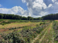
(4) Walk along the right-hand side of the meadow, then cross it to join a forest track running across.

(5) Follow it to the right until you reach a junction with another cross-country track.

(6) Turn right and head back up towards the forest. Follow this path to the end to return to Le Larrey. Walk down Rue de Verpillière to reach the Place du Château (S/E).

Waypoints

  1. S/E : mi 0 - alt. 1,204 ft - Place du - Château de Chissey-en-Morvan
  2. 1 : mi 0.38 - alt. 1,250 ft - Rue Fontaine
  3. 2 : mi 0.49 - alt. 1,306 ft - Chaumoux Farm
  4. 3 : mi 0.52 - alt. 1,329 ft - Cattle gate
  5. 4 : mi 1 - alt. 1,608 ft - Meadow
  6. 5 : mi 1.17 - alt. 1,647 ft - Forest track
  7. 6 : mi 1.95 - alt. 1,650 ft - Junction
  8. S/E : mi 3.41 - alt. 1,201 ft - Château de Chissey-en-Morvan

Reviews and comments

3.7 / 5
Based on 2 reviews

Reliability of the description
5 / 5
Ease of following the route
2 / 5
Route interest
4 / 5
Pymouss75
Pymouss75

Overall rating : 4 / 5

Date of your route : Aug 15, 2024
Reliability of the description : ★★★★★ Very good
Ease of following the route : ★★★☆☆ Average
Route interest : ★★★★☆ Good
Very busy route : No

A really lovely walk through the Morvan hills. Some lovely views, with sections through the forest or across fields.
The only downside: some of the less-used paths are overgrown with broom and brambles. It was very difficult going at times. We nearly turned back… It’s best to wear trousers on those stretches.
It would be a good idea to inform the mayor of the local council to make the landowners aware that regular maintenance would be much appreciated by walkers and hikers…

Machine-translated

Jan Van den Berghe
Jan Van den Berghe

Overall rating : 3.3 / 5

Date of your route : Jul 23, 2024
Reliability of the description : ★★★★★ Very good
Ease of following the route : ★☆☆☆☆ Very disappointing
Route interest : ★★★★☆ Good
Very busy route : No

In the first part of the walk, there’s a vicious dog on the road. After that, you have to go through a fence, and then the path becomes increasingly difficult to follow. Without a GPS, it’s impossible to find your way. And in the final stretch, before you reach a proper path, you have to cross a meadow. I wonder if the farmer’s happy about that.
The second part is perfect. The scenery is lovely, but in my opinion, it’s a bit of a rubbish walk.

J

Machine-translated

Other walks in the area

For more walks, use our search engine .

The GPS track and description are the property of this route's author. Please do not copy them without permission.