Route du Heron de Montigny-le-Gannelon

This route will allow you to explore the south-eastern part of the village. The route is signposted throughout with a heron symbol.

Details

n°1501034
Creation:
Last update:
Last review:
  • Walking
    Activity: Walking
  • ↔
    Distance: 3.43 mi
  • ◔
    Average duration: 1h 35 
  • ▲
    Difficulty: Easy

  • ⚐
    Back to start: Yes
  • ↗
    Ascent: + 10 ft
  • ↘
    Descent: - 10 ft

  • ▲
    Highest point: 331 ft
  • ▼
    Lowest point: 315 ft

Photos

Description of the walk

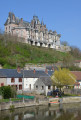
(S/E) At the entrance to the gravel pits, set off from the map display towards the mill. As you pass, enjoy the magnificent view of the castle.

(1) The mill and its lock will tell you the story of the River Loir. Continue straight on along the path.

(2) On the right, the dead-end path will take you down to the water’s edge. Turn left to continue the walk.

(3) When you reach the crossroads, turn right. The path bends sharply to the right.

(4) At the next junction, turn left and then carry on straight ahead, walking round the lake. You’ll pass behind the François Rabelais secondary school and behind the Trois Rivières water sports centre.

(5) At the junction, turn right to continue along the lake. You’ll pass just behind the Vorwerk Semco factory.

(6) At the next junction, turn left across the plain towards the woodland running alongside the gravel pit. Along the way, take full advantage of the view of the castle. The end of the path will bring you back to the starting point (S/E).

Waypoints

  1. S/E : mi 0 - alt. 322 ft - Map of the lake
  2. 1 : mi 0.14 - alt. 318 ft - Mill - Loir (rivière)
  3. 2 : mi 0.57 - alt. 322 ft - The hut
  4. 3 : mi 1.25 - alt. 331 ft - North-facing slope of Cloyes
  5. 4 : mi 1.95 - alt. 325 ft - Between the gravel pits
  6. 5 : mi 2.82 - alt. 322 ft - Vorwerk factory
  7. 6 : mi 3.15 - alt. 325 ft - Back to the castle - Château de Montigny le Gannelon
  8. S/E : mi 3.43 - alt. 322 ft - Map of the lake

Notes

- No particular difficulty.
- Parking available at the starting point.

Reviews and comments

4.7 / 5
Based on 1 review

Reliability of the description
5 / 5
Ease of following the route
5 / 5
Route interest
4 / 5
Christian P
Christian P

Overall rating : 4.7 / 5

Date of your route : Sep 20, 2020
Reliability of the description : ★★★★★ Very good
Ease of following the route : ★★★★★ Very good
Route interest : ★★★★☆ Good
Very busy route : No

A short, easy walk with lovely views of Montigny Castle.
The route is very well signposted.

Machine-translated

Other walks in the area

For more walks, use our search engine .

The GPS track and description are the property of this route's author. Please do not copy them without permission.