


 Country:
 City:
City:


Park in one of the car parks near the Pont de Bethléem on the River Yonne.
(S/E) Head towards Auxerre.
(1) About 150 metres further on, take the road leading uphill to the right, Rue de Sembert, which leads to the Croix Pataut.
(2) Turn left onto the track towards Sembert-le-Haut.
(3) At the entrance to Sembert, follow the track on the left (magnificent view over Clamecy and the Collegiate Church of Saint-Martin) and carry on straight ahead along the road leading to the pylon.
(4) About 200 m past the pylon, turn right onto the track that winds through a fir forest, crosses a field and joins a wider track. Turn right and you’ll reach the farm at Sembert-le-Haut.
(5) Take the path opposite, then keep left at the junction to head down to the hamlet of Les Perrières.
(6) Turn left and follow the road to Sembert-le-Bas. Walk through the hamlet, ignore the first path on the right leading to La Tuilerie and take the second one, 600 metres further down, also on the right. Join the first path branching off to the left.
(7) Follow this path through woods and fields to the D 951 at the entrance to Armes.
(8) Turn left, walk alongside the River Yonne for about 250 m, then go down the small flight of steps on the right. Cross the channels via two footbridges to reach the banks of the Canal du Nivernais.
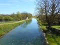
(9) Turn right, following the right bank of the canal. Pass the Maladrerie lock, cross another footbridge, then carry on straight ahead along the strip of land separating the River Yonne and the canal. You’ll reach the Picot Bridge.
(10) Do not cross the bridge but continue straight on along the Nivernais Canal Greenway. Once you reach Lock No. 47, take the footbridge on the left leading to the Quai du Pertuis. Turn right and head back to the Pont de Bethléem and the car park (S/E).


 Visorando Member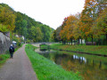

 Moderate
