Country:

 City:


Access:
- From Sisteron, take the D1085 (Route Napoléon) towards Gap. Turn left towards Barcillonnette onto the D20 at Vitrolles. Continue until you reach Esparron. Park on the left at the entrance to the village.
- From Veynes or Gap, head towards Sisteron via the D1085 (Route Napoléon). Turn right onto the D20 at Vitrolles, then continue to Esparron. Park on the left immediately upon entering the village.
(S/E) From the car park, head back down the D20 towards the south-east for about 600 m.
Leave the small tarmac road after crossing the bridge (over the Torrent de Rebiodon) at the sharp bend. Take the path on the right towards the Col des Garcins (wooden signpost). Follow theGRP® Entre Céüse et Durance, marked in yellow and red.
The first section begins with an ascent over very rugged terrain.
(1) You’ll soon reach the “Serre Claud” hiking marker. Continue straight on, climbing. Follow theGR®93, marked in white and red.
Walk alongside the Rebiodon Torrent ravine. The path then turns into a track suitable for vehicles (the Maraud forest track). Climb gradually via wide hairpin bends.
(2) After 2 km, leave the track (wooden signpost). Continue to the right towards Lac de Peysset. Follow theGR®93, marked in white and red.
Climb up to the Col des Garcins through the woodland.
(3) You’ll soon reach the pass (wooden sign, altitude 1,422 m).
Head right towards the west along a narrow path. No markings.
From here, there is little or no path or marking; the route described is one possible way forward.
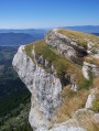
Follow the ridge formed by the marl and the fence on the left. Keep your eyes on the rocky summit in the distance: this is the Rocher de l’Aiglon.
Cross the marl ridges to reach the meadow known as ‘La Plaine’.
Continue climbing the grassy ridge on the left towards the Rocher de l’Aiglon.
When you reach the base of the rock, go round it from below.
Carry on heading north. Keep the second summit of the Montagne de Rochefort, the Rocher de Barras, in sight. Reaching it requires a bit of scrambling, using good handholds.
Descend, then, keeping your eyes on the next feature, head south-west towards the final summit, the Rocher de la Croix.
Continue for about 350 m southwards.
(4) You’ll find yourself halfway between the Rocher de l’Aiglon and the Rocher de la Croix.
Then head south-south-west. Descend for about 200 m until you find a path at the edge of the undergrowth.
Take this path and continue the descent.
You’ll reach the Laboudou sheepfold after a 1 km descent. Go round Lake Peyssier on the left.
Cross a small ford.
(5) At the “Lac de Peyssier” signpost, continue left towards the Col d’Aujour.
There is a small cairn at the start of the path. Follow it as it climbs up the grassy ridge, overlooking the ruins of Jas des Aigues (visible on the left). White/red markings forthe GR®94.
Carry on until you reach the edge of the forest at a junction on a flat stretch.
(6) A cairn marks the crossroads. To the left, theGR®94continues; to the right is a forest track.
Carry on down the centre along the path climbing through the undergrowth. An old yellow marker appears during the climb.
Emerge from the forest, passing beneath a beautiful grassy pass, from where you can see the Dévoluy rising up behind you.
Continue towards the scree field below the summit. The path becomes a mere track through this rocky area. Cairns and some old yellow markings (rare) make it easy to find your way.
Carry on northwards, descending slightly, to go round the rocks and the fault. Then follow the rocks until you find the entrance to the Aujour Fault on your left.
(7) Once you reach the Aujour Fault (see practical information), head towards the rocky ridge on the right. The fault continues beneath the rocks, forming a steep, narrow natural tunnel.
Look out for the passage through the rocky ridge; there is a yellow line marking the route, though it is almost faded (along with several metal plates in place). The passage is not particularly difficult and offers little exposure.
You will emerge onto the steep grassy slopes of the northern face. Climb as best you can to the summit, marked by a cairn. There is also a radio relay station nearby.
The summit offers a sweeping 360° panorama of all the mountain ranges: Drôme Provençale, Dévoluy, Champsaur, Les Ecrins, Mont Ventoux, Montagne de Lure…
Descend until you find yourself facing the fault line. Cross it. Reach the end of the fault line, then go round it to the south by turning right towards the eastern summit of the Montagne d’Aujour.
Walk along the southern faces of the Montagne d’Aujour on your right. The path is sometimes overhanging.
(8) After 900 m, reach a small pass. Stay on the south face of the cliff, continuing to the left.
You’ll reach the Col de l’Armande, coming out onto a track suitable for vehicles after 650 m.
(9) Follow this track to the right for about 150 m.
Turn left to climb the rocky spur ahead. Follow the path running along the ridge.
Follow this fairly well-marked track for nearly 1 km.
It then curves northwards. Continue for 100 m in this direction, then turn left onto a faint path through the vegetation. Walk alongside a fence on your left.
You’ll come to a better-marked path heading north-west.
Emerge from the woodland after 900 m to find yourself on a lovely ridge, which could be used as pastureland.
(10) You’ll come across several tracks, including one heading down to the right; ignore this and follow the ridge north-west.
(11) Reach the Roc de Longue Dent promontory, marked by an IGN boundary stone.
Turn back until you rejoin the descending path.
(10) Initially visible, the track is soon marked by several cairns. Pass in front of a hunter’s lookout post.
Continue down through a cleared area for a few hundred metres until you reach a clearly visible path.
(12) Continue down this path to the right.
You’ll soon emerge into a small clearing, where an old hut stands on the right at the edge of the forest.
Cross the clearing opposite the hut, then take the path that branches off slightly to the right. Walk for about 500 m through the woodland.
(13) In a more open area, you’ll come to a wooden signpost.
Continue to the right towards “Abbaye”. Yellow markings appear. Follow the single track, mainly through the forest, for nearly 1.8 km.
(14) You’ll arrive at a lovely clearing, facing the steep slopes of the Montagne d’Aujour.
Turn right at the entrance to the clearing until you come to a grassy track. Cross the clearing from west to east for 350 m.
Leave the clearing on the left. Take the track suitable for vehicles that you come to, then follow the yellow markings.
(15) Leave the track by turning left after 300 m. Yellow markings.
(16) You’ll arrive at the ruins of Clausonne Abbey.
Turn right onto the track leading to the ruins.
(17) At the fork in the road near the bridge, carry on straight ahead along the track. Follow signs for “Lac Peyssière”. Yellow markings. Follow the left bank of the Maraize torrent upstream.
(18) Pass a ford on the left after 650 m. Continue straight on, still following the left bank of the stream. You will soon reach the source of the Rascle.
The track curves sharply to the right after about 2 km. Follow it and cross the stream. Then walk along the right bank of the stream.
You’ll arrive below the dam at Lac de Peyssier.
(19) Climb onto the dam, turning left. Cross the dam to the concrete spillway.
Head back down and rejoin the track. Go through the barrier (remember to close it behind you) then walk along the lake.
(5) At the “Lac de Peyssier” signpost, carry on straight ahead.
Cross the ford again. Then follow the track round the pasture via theGR®93.
(20) At the “Peysset” signpost, turn left, leaving the track. Follow theGR®93. White/red markings.
Head up towards the Col des Garcins, following the right bank of the Torrent de Leyssalier. The route follows the stream bed for a short stretch.
Shortly before reaching the pass, go through a small access gate (make sure to close it properly behind you).
(3) Reach the Col des Garcins once more.
Head back down through the woodland until you reach the Maraud forest track. Continue down, following theGR®93, marked White/Red, to the “Serre Claud” signpost.
(1) Head for the finish, following the route taken on the way out and theGRP® between Céüse and Durance, marked with yellow and red signs (S/E).

 ), there’s no point in going there, but with a bit of planning, there are ways to avoid these few inconveniences.
 – I decided to turn back at the highest point of the Montagne d’Aujour, at point 7 to be precise.


 Visorando Member
 Moderate


 Difficult
 Association / Club / Walk leader