Mondhalde Kaiserstuhl

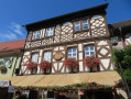
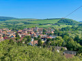
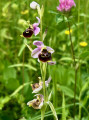
A lovely walk in the Kaiserstuhl with plenty of views. A third of the route is on quiet tarmac roads, mostly in the sun. In spring, the embankments are in bloom.

Details

n°65844629
Creation:
Last update:
Last review:
  • Walking
    Activity: Walking
  • ↔
    Distance: 6.28 mi
  • ◔
    Average duration: 3h 40 
  • ▲
    Difficulty: Moderate

  • ⚐
    Back to start: Yes
  • ↗
    Ascent: + 889 ft
  • ↘
    Descent: - 925 ft

  • ▲
    Highest point: 1,473 ft
  • ▼
    Lowest point: 748 ft
  • ⚐ Country: Germany
  • ⚐ City: Endingen 
  • ⚑
    Start/End: N 48.110534° / E 7.654154°
  • ❏
    IGN map(s): Ref. 3818O
  • Hour-by-hour weather

Description of the walk

Car park from Kiechlinsbergen towards Oberbergen, at the top of the Texaspass: park on the east side of the road. If there’s no space, try the car park on the west side.

(S/E) Take the Katharinapfad path westwards, climb the steps and continue across the meadow.

(1) At the junction, turn left towards Bassgeigenhütte and head for the car park serving the hiking chalet: ‘bassgeige’ means double bass, referring to the shape of the Oberbergen vineyard as seen from the air.

(2) Walk past the chalet and climb the steps to rejoin the path. Continue straight on to reach the Mondhalde Pavilion. On a clear day, there are views over the Alsace plain, the Kaiserstuhl vineyards and, with a bit of luck, as far as the Alps.

(3) Follow the road to the Roman column marking the start of the wine trail. Go down the steps and continue along the path to rejoin the road.

(4) Follow the road, turning right: there are several information boards in three languages along the wine trail. You’ll come to a junction.

(5) Turn left onto the Panoramaweg, which winds its way along the edge of Oberrotweil.

(6) Carry on to the left towards Oberbergen and walk through the village, keeping in the same direction. Follow the signs for Schellingen, which are clearly marked. Walk past the last houses in the village and continue for about a hundred metres.

(7) Turn left to head up through the Schellinger Vieweide pasture. If this seems too long, you can head up a few metres earlier towards Kiechlinsbergen Eck without going via the Vieweide; this shortens the distance by about 800 metres.

(8) The pasture is home to nandus (a type of emu), Highland cattle and goats, but these animals are not always out and about. Climb until you reach the junction with the Katharinapfad.

(9) Turn left.

(10) Go round the Staffelberg on the left, then head straight on to return to the car park (S/E).
Waypoints

  1. S/E : mi 0 - alt. 1,312 ft - Texaspass car park
  2. 1 : mi 0.16 - alt. 1,368 ft - Junction towards Bassgeigenhütte
  3. 2 : mi 0.55 - alt. 1,381 ft - Bassgeigenhütte
  4. 3 : mi 1.28 - alt. 1,145 ft - Mondhalde
  5. 4 : mi 1.5 - alt. 994 ft - Route
  6. 5 : mi 1.95 - alt. 807 ft - Panoramaweg
  7. 6 : mi 3.01 - alt. 771 ft - Junction, turn left
  8. 7 : mi 4.27 - alt. 886 ft - Ascent to the pasture
  9. 8 : mi 4.88 - alt. 1,198 ft - Vieweide
  10. 9 : mi 5.19 - alt. 1,381 ft - Katharinapfad
  11. 10 : mi 5.63 - alt. 1,457 ft - Staffelberg bypass
  12. S/E : mi 6.28 - alt. 1,306 ft - Finish

Notes

Avoid in very hot weather.

Reviews and comments

5 / 5
Based on 1 review

Reliability of the description
5 / 5
Ease of following the route
5 / 5
Route interest
5 / 5
ptk
ptk

Overall rating : 5 / 5

Date of your route : Mar 27, 2025
Reliability of the description : ★★★★★ Very good
Ease of following the route : ★★★★★ Very good
Route interest : ★★★★★ Very good
Very busy route : No

A lovely walk (thanks to the author). We explored the terraced vineyards and enjoyed some stunning views of the Vosges and the Alsace plain. Very easy (apart from the slightly steep half-hour climb between (7) and (8)). Walking sticks aren’t needed. Plenty of benches and picnic tables.

Machine-translated

Other walks in the area

For more walks, use our search engine .

The GPS track and description are the property of this route's author. Please do not copy them without permission.