Country:

 City:
City:


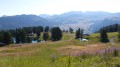
The start is at the 1,951-metre mark, at the end of the tarmac road coming from Saint-Marcellin. You can park at the side of the road on a bend.
(S/E) Turn left onto the dirt track leading to Peyrol. Walk southwards for about 2 km through the forest. Lac de Peyrol is on the right.
(1) Facing the chairlift, follow the maintenance track for the facilities, which climbs to the right and is marked in yellow. Then head up through the meadow, first north-west and then west.
(2) : Before reaching a hut, turn left, leaving the path on your right that leads up to the Razis ski lift. The route follows naturally along the well-marked path leading up to the Col du Vallon tunnel.
(3) Head left towards the Peyrol chairlift. Then make a round trip to the weather radar by taking the path on the right that leads uphill.
(4) Head back down the arrival path for a very short distance.
(5) Ignore the path leading down to the Col du Vallon and turn left towards the Col de Saluces.
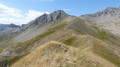
(:6) Then follow the unmarked but clearly defined path straight ahead (south-west), which is sometimes marked with cairns and climbs over a series of humps along the ridge towards Chabrières. Follow this well-marked ridge path – where you may occasionally need to use your hands – to reach the summit of Chabrières on the right.
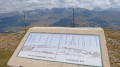
(7) Note the orientation table specific to each cardinal point. Continue south along the path and soon turn left towards a stony platform with wooden beams on the ground.
(8) From here you can see the speed ski run – a truly vertical wall – which is well worth seeing and imagining (especially if you don’t ski). Retrace your steps back to the orientation board
(7) Look out for the cairns on the left to help you find the start of the uphill path amongst the rocks, then head back to the Col de Saluces.
(6) Follow the path to the right, which climbs gently (leave the path you came along on the opposite side), then descend in a curve to the right, following the yellow markings.
Ignore a path leading uphill to the left and carry on straight ahead. Then, almost immediately, turn left, leaving the path that continues straight ahead.
Continuing downhill, with Lac de Peyrol visible below, the path leads back towards the Sainte-Marie chairlift.
(1) Go round the chairlift on the right. Keep the lake on your left. Follow the track back along the same route you took on the way up to the Cote 1951 car park (S/E).



 Visorando Member
 Moderate

 Association / Club / Walk leader