The Lakes of Orcières and Prapic

A circular walk starting from the Orcières resort to explore Prapic and the high-altitude lakes. There are plenty of options to shorten the walk if necessary.

Details

38769309
Creation:
Last update:
Last review:
  • Walking
    Activity: Walking
  • ↔
    Distance: 13.89 mi
  • ◔
    Duration according to the author: 7 hrs 
  • ▲
    Difficulty: Very difficult

  • ⚐
    Back to start: Yes
  • ↗
    Ascent: + 5,108 ft
  • ↘
    Descent: - 5,102 ft

  • ▲
    Highest point: 8,478 ft
  • ▼
    Lowest point: 4,964 ft

Photos

Description of the walk

To reach the start of this hike, before the Orcières resort, you can park in the car park at the entrance to the hamlet of Les Estaris, a hamlet with traditional chalets.

(S/E) Carry on straight ahead, following the signs for “Merlette O.T.”. Continue until you reach the sign for “Les huttes, alt. 1770 m”.

(1) Turn right onto a wide track before it quickly turns into a lovely little path winding along the slopes before climbing steeply. Carry on to the sign for “Alt. 2030 m”.

(2) Continue climbing until you reach the sign for “Le Balet”.

(3) Take the path that winds down in wide hairpin bends towards Prapic. The descent is straightforward, but crosses some steep slopes before ending at a bridge.

(4) Turn left to reach Prapic, following the tarmac road. At the tourist information office, keep right twice to reach a junction by the signpost indicating “Lac des Pisses 3h30”.

(5) Turn left as indicated by the sign. You’ll come to a Fork in the road.

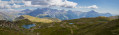
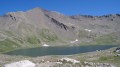
(6) Continue following the signs for Lac des Pisses by turning left. The path is clearly marked; it’s impossible to go wrong. After a long, steep climb, you’ll reach Lac des Pisses – the perfect spot for a picnic!
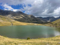
Follow the path that runs alongside the lake towards the Orcières resort. The route runs along the hillside but presents no particular difficulty. The end of the path marks a change of scenery as you arrive at the resort near Lac des Jumeaux.

(8) Start the tour of the six lakes of Orcières on the right and head towards the sign for ‘Le Laus’ (alt. 2,520 m).

(9) Keep to the right towards the Refuge des Estaris and its lake.

(10) Turn back to return to the previous junction.

(9) Continue to the right towards Lac Profond.

(11) Head towards Lac Long, keeping to the right.

(12) Walk along the eastern shore, then follow the path alongside the stream to rejoin a 4x4 track which leads to Lac des Sirènes.

(13) Cross the track to go round the lake on the left, then continue along the 4x4 track to reach the Chalet de Roche Rousse.

(14) After the hairpin bend to the left, leave the track and head off-track, then cut across a second track towards the Chalet de Roche Rousse.

(15) Do feel free to stop for a drink on the terrace. With the chalet opposite you, turn left towards the track you left earlier. Once on this track, turn right and then take the wide path on the left. Navigate a right-hand bend and you’ll come to a junction.

(16) Follow the small path on the left to move away from the mountain bike track. Then take the first path on the right, continue straight on, and a little further on you’ll rejoin the signposted path leading back to the Chalet Joubert.

(17) Follow the signs for “Forest des Estaris” by turning right. Then keep left twice until you reach the hamlet of Forest des Estaris.

(18) Do not follow the 4x4 track; instead, take the small path leading downhill, following the sign for “Sentier Joseph”. Continue to the end of the path, where you can see the huts 100 metres away.

(19) Carry on to the left and return to the junction you passed on the way there.

(1) Go straight on and follow the route in the opposite direction to the outward journey to return to the car park (S/E).

Waypoints

  1. S/E : mi 0 - alt. 5,653 ft - Les Estaris
  2. 1 : mi 0.26 - alt. 5,817 ft - Les Huttes (alt. 1,770 m). Junction of the circular route
  3. 2 : mi 1.48 - alt. 6,670 ft - (Alt. 2,030 m). Follow signs for Prapic
  4. 3 : mi 1.64 - alt. 6,896 ft - Le Balet (alt. 2,090 m)
  5. 4 : mi 3.52 - alt. 4,964 ft - Bridge, road junction
  6. 5 : mi 3.94 - alt. 5,131 ft - From the village centre, follow signs for Lac des Pisses – Prapic – Prapic - Arrêt navette Prapic
  7. 6 : mi 4.65 - alt. 5,259 ft - Fork in the road, towards Lac des Pisses
  8. 7 : mi 7.18 - alt. 8,205 ft - Lac des Pisses (Alps, Ecrins, Champsaur, Dauphiné) – Lac des Pisses (Alps, Ecrins, Champsaur, Dauphiné) - Lac des Pisses
  9. 8 : mi 9.29 - alt. 8,110 ft - Lacs Jumeaux (Orcières) – Lacs Jumeaux (Orcières) - Lacs Jumeaux
  10. 9 : mi 9.51 - alt. 8,261 ft - Le Laus (alt. 2,520 m)
  11. 10 : mi 9.73 - alt. 8,461 ft - Grand Lac des Estaris – Grand Lac des Estaris - Grand lac des Estaris
  12. 11 : mi 10.2 - alt. 8,117 ft - Lac Profond – Lac Profond - Lac Profond
  13. 12 : mi 10.39 - alt. 8,166 ft - Lac Long (Orcières) – Lac Long (Orcières) - Lac Long Orcières
  14. 13 : mi 10.75 - alt. 7,900 ft - Lac des Sirènes – Lac des Sirènes - Lac des Sirènes
  15. 14 : mi 11.11 - alt. 7,723 ft - Off-trail section
  16. 15 : mi 11.45 - alt. 7,500 ft - Chalet de Roche Rousse – Rocherousse Télémix – Rocherousse Télémix - Gare arrivée Télémix Roche Rousse
  17. 16 : mi 12.15 - alt. 7,211 ft - (Alt. 2,195 m). Junction towards – Lake Jujal – Lake Jujal - Lac Jujal
  18. 17 : mi 12.64 - alt. 6,772 ft - Near La Baume
  19. 18 : mi 13.1 - alt. 6,391 ft - Estaris Forest
  20. 19 : mi 13.49 - alt. 5,879 ft - Joseph Trail
  21. S/E : mi 13.89 - alt. 5,640 ft - Les Estaris

Notes

You can park at the resort in a car park at a place called “Les Huttes”, which allows you to set off directly onto the circular route.

This hike doesn’t require any special equipment; the path is in good condition all the way.
Thefirst section up to Lac des Pisses isn’t very busy (apart from the stretch through Prapic), so it’s a real pleasure.
The Lacs d’Orcières, on the other hand, are very busy. To avoid the crowds during the holiday season, follow the paths leading to the Cabane du Gouroud.

If your legs are tired or you’re not keen on the descent, you can take the ‘Télémix’ lift down for free.

The end of the descent takes you across the ‘Jujal’ green downhill mountain bike trail. There’s a marked route with small metal marmot markers; you should follow this one for a smoother ride.

This route passes through a protected area, which may be subject to special regulations:

Worth a visit

Do take a little time to enjoy the charming village of Prapic. The chalets and streets are lovely. A must-do hike starting from Prapic is, of course, the Saut du Laire; what’s more, this area is a marmot paradise.
At the foot of Orcières there’s a really lovely leisure centre for the little ones.
The Rocher d’Arthouse via ferrata is also a good option, but be warned: the first section isn’t as easy as it looks.

Reviews and comments

4.7 / 5
Based on 2 reviews

Reliability of the description
4.5 / 5
Ease of following the route
4.5 / 5
Route interest
5 / 5
Kristin7
Kristin7

Overall rating : 4.3 / 5

Date of your route : Aug 03, 2025
Reliability of the description : ★★★★☆ Good
Ease of following the route : ★★★★☆ Good
Route interest : ★★★★★ Very good
Very busy route : Yes

It is difficult to see how this could be achieved in a single attempt within the time frame mentioned.

Machine-translated

User 8013781
• Edited:

Overall rating : 5 / 5

Date of your route : Aug 02, 2025
Reliability of the description : ★★★★★ Very good
Ease of following the route : ★★★★★ Very good
Route interest : ★★★★★ Very good
Very busy route : Yes

A very beautiful hike with stunning scenery.
The route was easy to follow with the Visorando app, and we completed it in 2.5 days, going in reverse.
day 1: departure from point 19 with a short detour between points 17 and 16 to pass by Lac de Jujal (well marked on the ground), bivouac at point 8 on the shores of Lac Les Jumeaux.
day 2: arrival at point 5 Prapic, short detour to see the Saut du Laire (hike 37644), night at the Prapic campsite.
day 3: return from point 5 to point 1, arriving at the end of the morning.
Quite a lot of elevation gain in one day, I can confirm that this is a very difficult hike!

Machine-translated

Other walks in the area

For more walks, use our search engine .

The GPS track and description are the property of this route's author. Please do not copy them without permission.