The Passavant tile works route

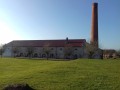
This trail reveals Passavant’s industrial past, passing close to six former tile works, three of which were still in operation in the 1950s. However, the advent of cement tiles hastened the closure of the last remaining tile works, causing the village’s population to halve.

Details

n°930495
Creation:
Last update:
Last review:
  • Walking
    Activity: Walking
  • ↔
    Distance: 5.62 mi
  • ◔
    Average duration: 2h 50 
  • ▲
    Difficulty: Moderate

  • ⚐
    Back to start: Yes
  • ↗
    Ascent: + 279 ft
  • ↘
    Descent: - 295 ft

  • ▲
    Highest point: 902 ft
  • ▼
    Lowest point: 761 ft

Photos

Description of the walk

Park in the Étang Neuf car park – Restaurant le Chalet du Lac (71 Grande Rue, Passavant-la-Rochère).

(S/E) From Le Chalet du Lac, take the D7 back down to the village of Passavant-la-Rochère.

(1) When you reach the fire station and the post office, turn left and walk behind the former Monchanin tile works (multi-purpose hall). Then continue to the right to head down to the centre of the village.

(2) Turn left onto the Grande Rue (D50), leaving the Rue de Vougecourt on your right, then take the second right, the Rue du Pateux. Continue to the right (Rue du Bourg), passing the church and the tower of the old castle. Take Rue de la Tour on your left and continue to the cemetery (the former site of the now-defunct Andon tile works).

(3) Head down the road on the left, which then becomes Chemin de la Nava, for 1.4 km. At the junction at the end of the road, you’ll see a tile works nestled in the woodland on your right.

(4) Turn left onto the wide track which leads out onto the D7. Turn right and follow this road as far as the bridge over the old railway line. Pass under this bridge, then walk past a former nightclub (which burnt down in 2013) and continue for a few more metres alongside the Canal de l’Est.

(5) Turn right, then right again, and follow the old railway line for 1.1 km. When you reach the old barrier, continue along the road to the right to join Rue de la Grande Fontaine in the village of Passavant (on your right, the remains of the Tuilerie Pourchot, which closed in 1982). Turn left.

(6) Then cross the D50 to the left and immediately turn right into Rue Mafioli. Turn left into Rue Saint-Antoine and continue until you reach a small chapel. Then follow the narrow path leading down to the left and pass under the viaduct

(7) Take the D50 to the right for 70 metres, then go back under the viaduct towards the pond. Pass in front of the ‘Forge en bas’ (site of the former Boileau-Mercier tile works and its manor house) and continue for 300 metres.

(8) At the crossroads, turn left and walk past the Upper Forge, then turn left to walk alongside the pond and return to the car park where you started (S/E).


Waypoints

  1. S/E : mi 0 - alt. 873 ft - Chalet du Lac restaurant
  2. 1 : mi 0.56 - alt. 860 ft - Turn left towards the community hall
  3. 2 : mi 0.84 - alt. 804 ft - RD 50, on the left
  4. 3 : mi 1.22 - alt. 889 ft - Cemetery, on the left
  5. 4 : mi 2.11 - alt. 823 ft - Crossroads; wide path to the left
  6. 5 : mi 3 - alt. 771 ft - Junction, turn right - Canal de l'Est
  7. 6 : mi 4.36 - alt. 899 ft - D50
  8. 7 : mi 4.65 - alt. 801 ft - D50, on the right
  9. 8 : mi 5.24 - alt. 843 ft - Crossroads, turn left
  10. S/E : mi 5.62 - alt. 873 ft - Start car park

Notes

Some sections are very wet when it rains; please wear suitable footwear

Worth a visit

Cristallerie Verrerie la Rochère – rue de la Verrerie 70210 Passavant-la-Rochère – www.larochere.com

Fountains and wash houses in the village.

Remains of the tile works.

Reviews and comments

4.2 / 5
Based on 2 reviews

Reliability of the description
4.5 / 5
Ease of following the route
4 / 5
Route interest
4 / 5
stephi469
stephi469

Overall rating : 3.7 / 5

Date of your route : Aug 03, 2020
Reliability of the description : ★★★★☆ Good
Ease of following the route : ★★★★☆ Good
Route interest : ★★★☆☆ Average
Very busy route : No

There’s a lot of cycling on roads and cycle paths, which isn’t particularly pleasant, but Passavant is magnificent and this route allows you to see it from both sides.

Machine-translated

Randonneuse64
Randonneuse64

Overall rating : 4.7 / 5

Date of your route : Aug 01, 2018
Reliability of the description : ★★★★★ Very good
Ease of following the route : ★★★★☆ Good
Route interest : ★★★★★ Very good

Due to a sudden storm, we left the route at point 4 and headed back along the road leading to the village. It was also lovely to see the old mill and walk alongside the river and the poplar plantation.

We were lucky enough to have a chat with some people who used to work at the last of these brickworks to have been in operation!

Machine-translated

larpète
larpète

Hello everyone
The hike hasn’t taken place yet.
I’ll be sure to give my opinion as soon as possible.
I live just a few kilometres from where this walk is taking place, so I’ll be able to join in at very short notice.
Have a lovely day, everyone
larpète

Machine-translated

gazok54
gazok54 ★

Thanks, larpète – good point. An automatic recalculation now gives an elevation gain of 52 metres. That’s more accurate.

Machine-translated

larpète
larpète

Hello everyone
The walk did not go ahead for various reasons, notably because the paths were too muddy (due to flooding).
Just a quick note, however, regarding the elevation gain.
177 metres would be more accurate for this walk than 1,770 metres.
No one is immune to this sort of mistake...
Have a lovely day, everyone
larpète

Machine-translated

Other walks in the area

For more walks, use our search engine .

The GPS track and description are the property of this route's author. Please do not copy them without permission.