The ‘Sentier des Biches’ trail in Claudon

An easy walk, though with a few steep sections. An interesting hike taking in historical heritage, legends and the Pont Tatal. The trail is signposted and maintained by the Club Vosgien (Blue Ring).

Details

n°29842235
Creation:
Last update:
Last review:
  • Walking
    Activity: Walking
  • ↔
    Distance: 4.23 mi
  • ◔
    Average duration: 2h 15 
  • ▲
    Difficulty: Easy

  • ⚐
    Back to start: Yes
  • ↗
    Ascent: + 394 ft
  • ↘
    Descent: - 413 ft

  • ▲
    Highest point: 1,060 ft
  • ▼
    Lowest point: 856 ft
  • ⚐ Country: France
  • ⚐ City: Claudon (88410)
  • ⚑
    Start/End: N 48.031874° / E 6.034341°
  • ❏
    IGN map(s): Ref. 3318SB, 3319SB
  • Hour-by-hour weather

Photos

Description of the walk

Starts from Claudon Church.

Blue Ring signposting

(S/E) With your back to the town hall, turn right and head towards the junction. Continue to the left, leaving the village via the Route de Darney (D5), and look for the start of a path on the right at the bend to the left of the road.

(1) Take this path, marked with the Blue Ring, which descends towards the stream below. Note the village wash house, then cross the stream. Pass a small signpost indicating a polishing stone once used by prehistoric people in this region, then turn left at the crossroads. At the next junction, continue straight on towards La Source and the Grotte de l’Ours (you can make a detour to the right to the Fossés de Châtillon and back). The path turns right and climbs up to a fork. Take the left-hand path, then left again, and descend for about a hundred metres (steep section), then turn right and rejoin the tarmac road.

(2) Cross the road and follow the path opposite, which branches off to the right below the road. Walk past the ice house, cross the bottom of the valley and you’ll soon reach a fork in the path.

(3) Turn right towards the Grotte Notre-Dame de la Source, walk a few dozen metres, then retrace your steps.

(3) Carry on straight ahead until you reach a road.

(4) Turn left, take in the sight of the beautiful fountain, which is still in use, then head right towards the Abbaye Notre-Dame de Droiteval.

(5) Carry on along the forest road as it climbs up to the plateau, then take the track, Tranchée de la Cabiole, which starts off at a right angle to the left.

(6) Follow this track to the small bridge.

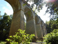
(7) Turn left downhill, then cross the 63-metre-high viaduct (Pont Tatal) spanning the River Ourche. Immediately afterwards, turn left, then quickly right, and join the Tranchée de la Roche Vinaigre. Follow this track to Claudon and its church (S/E)

Waypoints

  1. S/E : mi 0 - alt. 1,056 ft - Église Saint-Guérin (Claudon)
  2. 1 : mi 0.32 - alt. 994 ft - Start of the trail
  3. 2 : mi 1.08 - alt. 899 ft - Route
  4. 3 : mi 1.23 - alt. 892 ft - Access to the - Grotte Notre-Dame de la Source
  5. 4 : mi 1.47 - alt. 866 ft - Route - Ourche (rivière)
  6. 5 : mi 1.68 - alt. 856 ft - Abbaye de Notre-Dame (Droiteval)
  7. 6 : mi 2.25 - alt. 1,037 ft - Gabiolle Trench
  8. 7 : mi 2.86 - alt. 922 ft - Pont Tatal
  9. S/E : mi 4.23 - alt. 1,056 ft - Église Saint-Guérin (Claudon)

Notes

Route signposted by the Club Vosgien.

(5) Notre-Dame de Droiteval Abbey, a private abbey with a beautiful organ.

(7) You can go bungee jumping from the bridge.

Find the longer version of this walk on the website www.camping-vosges-nature.com, under the ‘Hikes’ section.

Worth a visit

Le Polissoir, a block of sandstone used for polishing objects made of bone, stone or metal.

(1) La Fontaine du Bois, a former wash house.

Between (1) and (2), the Grotte de l’Ours and the Châtillon ditches.

(3) Notre-Dame de la Source, a rock formation resembling a cave.

(7) The Pont Tatal, a viaduct built in 1885.

Reviews and comments

5 / 5
Based on 1 review

Reliability of the description
5 / 5
Ease of following the route
5 / 5
Route interest
5 / 5
KEKEK
KEKEK
• Edited:

Overall rating : 5 / 5

Date of your route : Mar 10, 2025
Reliability of the description : ★★★★★ Very good
Ease of following the route : ★★★★★ Very good
Route interest : ★★★★★ Very good
Very busy route : No

A lovely walk
The signposting was spot on (even in the areas ravaged by tree felling, you could still spot the little Blue Circle on a post : )
A magnificent walk with some lovely surprises (the fountain, the stone for polishing, the viewpoints, the abbey and the surprise of the Tatal Bridge...)
No difficulties (a few steep climbs but never too much).
Thank you for this wonderful experience

Machine-translated

Other walks in the area

For more walks, use our search engine .

The GPS track and description are the property of this route's author. Please do not copy them without permission.