Country:

 City:
City:


Park in the car park of the Pays de Gavot secondary school, set back from the D52 road linking Saint-Paul-en-Chablais and Larringes. Note a GéoPark Chablais information board about peat bogs.
Signposts are provided at major junctions.
No signposting
(S/E) Head for the eastern exit of the car park and follow the D52 towards Saint-Paul (east), keeping to the right-hand verge.
Yellow markings
Take thefirst right, towards Maravant and Vinzier, and walk past a sports hall on your left. Shortly afterwards, ignore the boardwalk to the Marais du Maravant on your left and continue straight ahead along the small, gently ascending road. At the end of the tarmac road, ignore a turn-off on the right and carry on straight ahead along a gently sloping stony track through the meadows. At the T-junction, turn right towards Vinziers and head towards a wood.
Signposts with yellow arrows (on both sides) + blue markings (on one side, in the opposite direction to your walk)
(1) At the signpost: Bois de Maravant, turn left towards the Abbey and stay on the edge of the woodland. At a Fork in the road, veer right and enter the woodland. Continue further between the woodland (on the left) and a vast meadow (on the right). Then cross a small, sparse copse and reach the edge of a meadow.
(2) Take a gap in the fence, cross the meadow and exit via asecond gap. Continue straight on into another meadow and follow a fence lined with trees on your right-hand side. At the end of this fence (at a place called Les Cézeaux), turn right. After a few dozen metres, follow a stony path to the left which crosses a meadow. You’ll come out onto a small road; follow it to the right for about fifty metres.
Unmarked
(3) Take thefirst left, the Chemin de l’Isalon. At the Stop sign, cross the D21 and follow it to the left for about 250 m (be careful, as there is heavy traffic; stay on the right-hand verge, which is wider than the left-hand one). Then turn right onto the Route de Pessay. Ignore the cul-de-sac of the same name on the left and continue to a junction with the Chemin du Champ Pollien.
Mountain bike signpost 1/11
(4) Follow a farm track to the left. Pass a livestock building on your left and continue downhill along a shaded path (view of the Dent d’Oche on the right through the branches).
No signposting
(5) Just before a stream crosses the path, turn sharply left and climb a steep hairpin bend. Continue uphill with a fenced-off meadow on your left and the stream below on your right. At the end of the path (opposite house no. 267), follow a small road to the left and continue climbing. Ignore a path branching off to the left and turn right with the road. At the T-junction (sign marking the entrance to the hamlet of Chez Bochet on the right), turn left. At the next junction (Rue du Pardon and Vers les Granges), turn right at the edge of a woodland (signpost). You’ll soon come to an information board about the peat bogs.
(6) Then turn left and enter the woodland (ignore the yellow arrow indicating you should continue straight on along the edge of the woodland). After a short climb, head back down. At a junction, go straight on and continue down through the woods. Further on, follow a faintly marked path along the edge of the woods on your left and a meadow on your right. At the end, enter the woods again and follow a sunken track running parallel to the road on your left.
(7) Cross Rue des Bassins and follow Route des Quatre Vents straight ahead, slightly downhill. Before the road starts to climb again, take a path on the right (marked for mountain biking). After about 250 m, take thefirst path on the right and pass by the base of an electricity pylon. At the T-junction, turn left, pass through the hamlet of Chez Thiollay and head downhill. At the ‘give way’ sign, first turn right then left to join the small road signposted ‘Chez Collomb’. At number 343, turn sharply left, go round a farm on the left and pass through a residential area.
(8) At the Stop sign, cross the D21 (caution: busy road; no pedestrian crossing but good visibility in both directions). Follow the road to the left and immediately turn right towards the recycling bins onto a small tarmac track (a remnant of the old road). At the recycling bins, follow the road to the right, where the speed limit is 30 km/h.
Yellow signposting
At the ‘Gremey’ sign, turn left. Ride straight through the hamlet and ignore a dead-end on the left. At the Stop sign, cross the road and follow it to the right, keeping to the left-hand verge.
No signposting
At the junction by the gym, carry on straight ahead and you’ll soon see the secondary school car park on your left (S/E).

 Visorando Member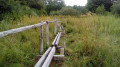


 Moderate