


To start the walk, meet in front of the football ground in Vaux-les-Saint-Claude.
Yellow markings
(S/E) Start the route heading north. Pass a road on your right, continue along a wide path and, after 100 m, you’ll reach a fork.
(1) Carry on straight ahead and head north-west, along the Bienne, until you reach the point where the wide path splits into two tracks.
(2) Take the path heading west. At the ‘Au Broteau’ signpost, follow the direction of Grotte de Nerbier (yellow markings). Continue until you reach the area upstream of the Plana farm.
(3) Please note that the route here does not match the IGN map: the path has been privatised. Turn right onto the gently ascending path and continue to the crossroads.
(4) Turn left to rejoin a wide stony path and head west. Continue until you reach the signpost for Grotte de Nerbier.
(5) Leave the stony path and head off to the right, following the signs for ‘Vers Grotte de Nerbier’. Climb up to the Grotte de Nerbier.
(6) With your back to the cave, continue south-west along a steeply ascending path. Pass a viewpoint and carry on until you reach the junction with a wide stony path.
(7) Head right, towards the north-west, and stay on the path until you reach the signpost for ‘Le Griottier’.
(8) Turn left onto a descending path and continue to the small bridge over the Héria.
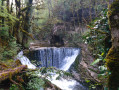
(9) After the bridge, head south, following the Héria. Walk to the waterfall, followed by the ruins of the Moulin du Griottier, then, following the yellow markings, return to the bridge.
(9) Cross the small bridge again and head back up to the ‘Le Griottier’ signpost.
(8) Carry on to the left along the stony path towards Grand Châtel. Pass under the high-voltage power line and, after several bends, continue to the junction with a tarmac road.
(10) Turn left and carry on until you reach the fountain in the hamlet of Grand Châtel.
(11) Carry on straight ahead (south-east) along the Chemin de Chatillon. You’ll reach the hamlet of Petit Châtel. Pass the drinking water fountain and continue to the farm.
(12) Turn right, then, at the next farm, carry on to the left, heading south-east. Pass under and walk alongside a high-voltage power line and continue to the Fork in the road.
(13) Please note: here, ignore the yellow markings; turn right, heading south-east, onto the path running parallel to the high-voltage line. Carry on until you reach the T-junction.
(14) Head right, towards the south. Continue along this path until you reach the Roche de Vaux signpost.
(15) Leave the wide path and turn right onto the descending track, following the signs for Chapelle Saint-Romain. Walk down to the T-junction.
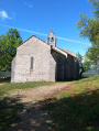
(16) Carry on to the right, heading south-west, and continue to the Chapelle Saint-Romain.
(17) In front of the chapel, continue to the right, following the dry stone wall. Carry on along the path, which soon begins a steep descent. Please note: in wet weather, the path may be dangerous. Use the ropes to help you down the slope, follow the orange markings on the trees and continue down to the path alongside the River Bienne, at the junction you passed on the way out.
(1) Turn left and walk on to the football ground (S/E).
The Nerbier Cave and the Griottier Waterfall


This route takes you to the Nerbier Cave where, in 1899, five workers were trapped by a sudden flood. A statue of the Virgin Mary commemorates the successful outcome of their rescue. You then continue on to the Griottier waterfall, nestled at the back of a wooded area. The return route takes you via the Saint-Romain Chapel, followed by a difficult descent back to the starting point.
Details
-
 Activity: Walking
 -
 Distance: 8.58 mi
 -
 Average duration: 5h 25
 -
 Difficulty: Difficult
 -
-
 Back to start: Yes
 -
 Ascent: + 1,719 ft
 -
 Descent: - 1,699 ft
 -
-
 Highest point: 2,238 ft
 -
 Lowest point: 1,073 ft
-
 Country:
France
Country:
France
-
 Areas: Jura mountains, Haut-Jura
 -
 City:
Vaux-lès-Saint-Claude (39360)
City:
Vaux-lès-Saint-Claude (39360) -
 Start/End: N 46.357442° / E 5.742814°
 -
 IGN map(s): Ref. 3327OT, 3328OT
 -


 Hour-by-hour weather
Photos
Description of the walk
Waypoints
- S/E : mi 0 - alt. 1,093 ft - Football stadium
- 1 : mi 0.18 - alt. 1,093 ft - Crossroads at the end of the circular loop - Bienne (rivière)
- 2 : mi 0.43 - alt. 1,099 ft - Fork - Bienne (rivière)
- 3 : mi 1.06 - alt. 1,135 ft - Plana Farm. New path
- 4 : mi 1.6 - alt. 1,086 ft - Crossroads
- 5 : mi 2.23 - alt. 1,079 ft - Signpost for the Grotte de Nerbier
- 6 : mi 2.31 - alt. 1,135 ft - Nerbier Cave
- 7 : mi 2.46 - alt. 1,165 ft - Junction with a wide stony path
- 8 : mi 3.32 - alt. 1,572 ft - Signpost for Le Griottier
- 9 : mi 3.48 - alt. 1,467 ft - Small bridge over the Héria
- 10 : mi 4.83 - alt. 1,906 ft - Junction with a tarmac road
- 11 : mi 5.08 - alt. 1,969 ft - Fountain in the hamlet of Grand Châtel
- 12 : mi 6.18 - alt. 2,195 ft - Farm in the hamlet of Petit Châtel
- 13 : mi 6.56 - alt. 2,192 ft - Fork in the road
- 14 : mi 6.83 - alt. 2,224 ft - T-junction
- 15 : mi 7.64 - alt. 2,119 ft - Signpost at Roche de Vaux
- 16 : mi 7.79 - alt. 1,962 ft - T-junction
- 17 : mi 7.96 - alt. 1,837 ft - Chapelle Saint-Romain de Roche
- S/E : mi 8.58 - alt. 1,093 ft - Football stadium
Notes
Caution: dangerous descent after (17). Do not attempt this section with children; use the ropes for support. Hike completed by the author on 25/04/2024
Worth a visit
(6) Nerbier Cave (9) Small bridge over the Héria, waterfall and ruins of the Moulin du Griotier (11) Fountain in the hamlet of Grand Châtel (17) Saint-Romain de Roche Chapel
Reviews and comments
5 / 5
5 / 5
4 / 5

Overall rating : 5 / 5
Date of your route : Dec 04, 2025
Reliability of the description : ★★★★★ Very good
Ease of following the route : ★★★★★ Very good
Route interest : ★★★★★ Very good
Very busy route : No
This hike takes place mostly in the forest and features beautiful waterfalls during this season. After Petit Chatel, I modified the route slightly by continuing on to the Champied marble quarry. At Saint-Romain, I preferred to avoid the direct and slippery descent to Vaux, so I followed zbh0170's alternative route (no. 4456936) passing under the Roche de Chiriat, which was longer but so enjoyable! Many thanks to both authors!
Machine-translated
Overall rating : 4.3 / 5
Date of your route : Aug 19, 2024
Reliability of the description : ★★★★★ Very good
Ease of following the route : ★★★★★ Very good
Route interest : ★★★☆☆ Average
Very busy route : No
A lovely walk. Varied scenery.
To avoid the difficult descent, we did the route in the opposite direction and tackled the steep climb via the PR path, which is on the right after the football pitches (Granges de Chinat)
Mind you, you need to be in very good shape. But after that, it’s practically all downhill.
It’s still a challenging 15km walk, though.
Machine-translated
Other walks in the area
Saint-Romain-de-Roche via Vaux-Lès-Saint-Claude
 Visorando Member
 4.07 mi
+1,358 ft
-1,348 ft
3h 05
Difficult
4.07 mi
+1,358 ft
-1,348 ft
3h 05
Difficult
 Departure from Vaux-lès-Saint-Claude (Jura)
7 Tales on a Walk: The Tender-Hearted Witch
 1.66 mi
+69 ft
-69 ft
0h 50
1.66 mi
+69 ft
-69 ft
0h 50
 Easy
Departure from Vaux-lès-Saint-Claude (Jura)
Easy
Departure from Vaux-lès-Saint-Claude (Jura)
The remote valleys of the Enragé
 5.26 mi
+1,322 ft
-1,309 ft
3h 35
Difficult
Departure from Pratz (Jura)
5.26 mi
+1,322 ft
-1,309 ft
3h 35
Difficult
Departure from Pratz (Jura)
From the Grotte de l’Enragé to the Plateau de la Roche Lezan
 4.22 mi
+1,122 ft
-1,122 ft
2h 55
4.22 mi
+1,122 ft
-1,122 ft
2h 55
 Moderate
Departure from Chassal (Jura)
Moderate
Departure from Chassal (Jura)
From Jeurre to Saint-Romain de Roche (circular)
 9.40 mi
+1,811 ft
-1,821 ft
5h 55
Difficult
Departure from Jeurre (Jura)
9.40 mi
+1,811 ft
-1,821 ft
5h 55
Difficult
Departure from Jeurre (Jura)
Jeurre – Montcusel circular loop
 10.61 mi
+1,585 ft
-1,572 ft
6h 15
Difficult
Departure from Jeurre (Jura)
10.61 mi
+1,585 ft
-1,572 ft
6h 15
Difficult
Departure from Jeurre (Jura)
Grand Châtel – Saint-Romain de Roche circular loop
 8.28 mi
+2,224 ft
-2,198 ft
5h 45
Difficult
Departure from Villards-d'Héria (Jura)
8.28 mi
+2,224 ft
-2,198 ft
5h 45
Difficult
Departure from Villards-d'Héria (Jura)
From the Lizon Tram Viaduct to the Pas de L’Âne
 7.76 mi
+1,027 ft
-1,027 ft
4h 30
Moderate
Departure from Lavans-lès-Saint-Claude (Jura)
7.76 mi
+1,027 ft
-1,027 ft
4h 30
Moderate
Departure from Lavans-lès-Saint-Claude (Jura)
For more walks, use our search engine .
The GPS track and description are the property of this route's author. Please do not copy them without permission.

