Country:

 City:
City:


Park near the Espace Prairial.
(S/E) In front of the Espace Prairial, head towards Clavière by following the Tranchée Couverte de Montgenèvre and cross the village via the Route d’Italie, going round a roundabout to reach the start of the walks.
(1) Follow the path towards Clavière and head for the motorhome site.
(2) Take the path on your right. The descent towards Clavière is very easy and pleasant. You’ll reach the N97, the Route de France.
(3) Cross it carefully and continue left into the village of Clavière along the Via Nazionale until you reach a roundabout.
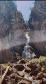
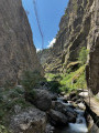
(4) Turn right onto the path situated on a small hillock between the road and the Masaniello restaurant, heading down into the valley. Pass the San Gervasio Chapel on the hillock and begin the descent, which is slightly steep. Pass the start of the Tibetan Bridge on your right and continue down towards the bottom of the gorges.
(5) At the bottom of the gorges, take the path on the right to walk back up them. The climb is very gentle and pleasant, winding its way around a small stream.
(6) Take the steps, pass the Bunker Via Ferrata, then climb all the way back up the gorges after a short zigzagging ascent.
(7) At the top, pass under the Coche chairlift to rejoin a wide path leading down towards Clavière.
(8) Continue left along this lovely forest path towards Montgenèvre.
(9) Turn right to head back towards Montgenèvre via a wide path. Pass close to Lac du Moulin de la Folie and Lac du Petit Peychier, and you’ll arrive at a nursery school.
(10) Turn right,cross the N97 (Route de France) with care, and take the Route d’Italie on the left, heading towards the Espace Prairial (S/E).



 Visorando Member
 Moderate
 Difficult