Country:

 City:
City:



(S) From the Utelle municipal lodge, walk along the north side of the church. Turn right and head for the junction at the end of Place de la République.
(1) At the signpost, on the corner by the fountain, turn left (west) onto the narrow Rue Émile Passeroni, heading towards Levens via the GR®5. At the car park at the end of the street, you’ll come to a Fork in the road.
(2) Ignore the path leading down to the right and take the one going up to the left. Cross the Vallon de la Cousta, go round its ridge and descend gently towards the bottom of the Vallon de l’Aclap. Cross the stream and head down the opposite slope to reach a junction.
(3) At the signpost, ignore the path to the right and carry on straight ahead. Cross two more valleys and reach a junction.
(4) At the signpost, ignore the path to the left and continue down the slope opposite. Walk past the Saint-Antoine Chapel, which can be used as a shelter. After 400 m, ignore a path on the right. Cross a small valley and, below the Crête de la Pallu, begin a long descent into the Gorges de la Vésubie. Cross the Pincinié Stream and, via straight switchbacks down the slope, reach a Fork in the road.
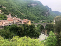
(5) At the signpost, stay on the path to the left. Enter the hamlet of Cros d’Utelle, join Rue Serre de la Trinité, then walk alongside the church to reach a triangular square.
(6) At the signpost in the square, stay on the street to the left. On the left, walk past the last house and immediately go down the steps. Walk alongside a hairpin bend on the M67 road. Take the shortcut to the left, crossing the road twice before rejoining it further down.
(7) Turn left onto it. As you come out of the hairpin bend, leave the road and take a path on the left through a gap in the low wall. Walk alongside the M67 and pass through the hamlet of La Madone. Take a flight of steps to rejoin the road. Follow it down to the left and you’ll come out onto the M2565. Opposite, you’ll reach a junction.
(8) At the signpost, continue to the right, cross the Vésubie via the Pont du Cros and, through the woods, climb diagonally up the north-facing slope of the valley. Cross the Vésubie canal (alt. 280 m), then climb a few hairpin bends. Pass a quarry and then a waste disposal site. Join the M19 road and cross it.
(9) At the signpost, ignore the path to the left and follow the track straight ahead. Go through a gate and, 30 m further on, at the bottom of the valley, ignore the path straight ahead (south-east). Follow the one to the right (west) then (south). Ignore a path to the left and rejoin the M19.
(10) At the signpost, continue along the road straight ahead and enter Levens; 200 m further on, you’ll reach a junction.
(11) At the signpost, leave the M19 and turn right onto the M519, Avenue Maréchal Foch. Ignore the Allée de la Forge on the left and, at the Fork in the road, keep left onto the M519. In the bend, pass the Rue de l’Escalada, which climbs to the right. At the top, leave the M519 as it bends right and turn onto Chemin des Valettes. You’ll come to a junction straight away.
(12) At the sign, leave Rue Héraud on your right and turn left. Go down a flight of steps. At the bottom, you’ll come out onto the street, Chemin de la Mole.
(13) At the sign, turn left and immediately join the M819, Avenue Charles David. Follow it to the right. In the bend, ignore a street on the right and, at the junction, turn left onto the M20, Route de la Roquette. In its hairpin bend, leave it to take a path on the right running alongside a stone wall. Rejoin the M19, Avenue du Général de Gaulle.
(14) Follow it straight on (south-east) until you reach a pavement bordered by a low wall on the left and a railing on the right. Go down the path to the right of a gate. Cross the footbridge over the Riou and, immediately afterwards, turn onto the path on the left which leads to the street, Chemin du Vignal.
(15) Turn left and, 60 metres further on, turn left again to join the Route de Saint-Blaise. Take this road to the right, ignore a street on the right and, immediately, reach a junction
(16) At the sign, leave the road and turn left onto Promenade des Prés. After 700 metres, just before it bends to the left, look out for a flight of steps on the right.
(17) At the sign, climb the steps and continue along a path. Shortly afterwards, ignore a track on the left and join a path. Follow this to the left (south), ignoring any side paths. Cross a forest track.
(18) Next, cross a stream bed. After 100 metres, turn left (east) and, at the fork 70 metres further on, keep to the right. Join another forest track (elevation 584). Follow it to the left and, immediately, leave it to climb the path on the right (south). After a few hairpin bends, join a track.
(19) At the signpost, head left, climbing gently up the slope of the Vallon de Saint-Blaise. Enter the hamlet of Sainte-Claire and arrive at a junction.
(20) At the signpost, turn right onto the Route de la Grau. Ignore the three dead-end roads on the right, one after the other, then the one on the left. About 200 m further on, you’ll reach a Fork in the road.
(21) At the signpost, leave the road straight ahead and keep left onto the ascending Rocca Partida track. Go through the gate and, further on, reach a crossroads at Colla Partida.
(22) At the signpost, leave the track straight ahead and take the first path on the right. At the Fork in the road, 300 m further on, leave a path on the right and, turning left, reach a crossroads.
(23) At the signpost, ignore the path on the left, then the track, and on the other side, ignore the first track and the one furthest to the right. Climb the ridge via the path between these last two. Ignore a branching path heading down to the left (marker 672) and, heading straight on, reach a fork.
(24) At the signpost, leave the ridge path to the right and turn off onto the path on the left, traversing the slope. Pass a high point (altitude 730) and descend gently to a track.
(25) At the signpost, follow it to the left and pass under a high-voltage power line. Ignore the side paths and continue to a fork at a place called La Treille.
(26) At the signpost, leave the track as it bends to the right and take the path on the left. At the Fork in the road, 50 m further on, leave this path and take a track on the right which descends to a junction at the foot of a mast at the entrance to the village of Aspremont.
(27) At the signpost, head left onto the Route de Barri. About 50 metres further on, at the junction signpost, take the path on the right which leads down to the Route de la Cima. Follow it against the flow of traffic to the left and reach the car park at the Place des Salettes du Commandant Gérome.
(28) On the right, go down the dead-end road, Montée du Commandant Gérome, and arrive at a hairpin bend on Avenue Caravadossi. Turn right onto it. Ignore a street on the left and the Impasse du Cimetière on the right. After 50 m, opposite the Espace Loisir, you’ll see a gap in the low wall on the left.
(29) At the sign, go down the steps and turn left onto the M14, the Route de Nice. At the Fork in the road, 150 m further on, continue right for 30 m until you reach a pedestrian crossing.
(30) At the sign, go down the steps on the right. Opposite, cross the car park (south-east). Take the Chemin de la Vallière, which runs below the M14. Further on, rejoin the M14 at its hairpin bend.
(31) At the sign, take the Chemin de Campoun opposite (east-south-east). Walk past the school and, in front of the tennis courts, reach a junction.
(32) At the signpost, head up the path to the right (west), then (south), ignoring the side paths. Pass to the right of the Fort du Mont Chauve d’Aspremont and, shortly afterwards, you’ll come to a bend in the Piste des Morgues.
(33) At the signpost, follow the track straight ahead for 120 m. At the fork, ignore the path on the left and take the one straight ahead (south), slightly below the Crête de Graus, ignoring any side paths. You’ll reach a crossroads.
(34) Cross the track and, immediately at the Fork in the road, keep to the right. Pass under a high-voltage power line. Further on, ignore a path leading in the opposite direction to the left. At the Fork in the road (elevation 448), keep to the left (south). Under another high-voltage power line, turn right (south-west) until you reach a crossroads.
(35) At the sign for the hamlet of La Vallière, cross the path and head down the slope opposite (south-south-west), ignoring any side paths. Enter Nice via a track running under a high-voltage power line.
(36) At the sign, turn left. After 100 m, at the junction, keep left onto the Chemin de Châteaurenard. At the crossroads, ignore the dead-end streets and stay on the Chemin de Châteaurenard (east-north-east) under the high-voltage power line. Ignore the alleyway on the left and arrive at the roundabout at a junction.
(37) On the right, ignore Avenue Jules Romain and take the next street, Vieux Chemin de Gairaut (south). Ignore the side streets and, opposite La Gairautine Primary School, you’ll come out onto the M14, Avenue de Gairaut.
(38) Cross it and follow it to the left. About 250 m further on, ignore a one-way street on the right. After 100 m, opposite a pedestrian crossing, look out for a flight of steps on the right.
(39) At the sign, go down the steps, continue along the Vieux Chemin de Gairaut and, 100 m further on, cross Avenue de Gairaut.
(40) Ignoring the side streets, head down the street opposite – the Vieux Chemin de Gairaut – straight ahead (south), ignoring the side streets. Cross the bridge over the motorway. At the Fork in the road, leave Avenue Gravier on your right. Continue straight ahead on the same street until you reach a junction with traffic lights.
(41) Cross the avenue and, on the opposite side, continue along the street. Cross Avenue Alfred de Vigny and carry on straight ahead along the Vieux Chemin de Gairaut until you reach Avenue Henry Dunant.
(42) Head straight along it and, at the end of the public garden at Place Alexandre Médecin, turn right, then immediately join Avenue Alfred Borriglione.
(43) Leave the GR®5 opposite, heading towards Rue Paul Bounin. Follow the avenue to the left (south). From Rue Puget, walk alongside the tram tracks and cross Place du Général de Gaulle. Continue straight on along Avenue Malausséna (south-south-east). Pass under the railway lines. Immediately turn right onto Avenue Thiers and head for the station entrance.(E) From the station, to reach the Les Camélias youth hostel, head back along Avenue Thiers (east-north-east), then continue along Rue Rassalit and take the second street on the right, Rue Lamartine, until you reach Rue Spitalieri.
 Visorando Member
 Moderate