Country:

 City:
City:


If you are not walking the route as part of a multi-day hike, you can plan your journey by public transport here: Getting there – local public transport
You start at the gateway to the Albsteig (Feldberg Pass), which is the end point of the final stage.
(S) From the Feldberg Pass summit, head towards the B317 main road and turn right there.
After about 120 m, turn right onto a tarmac path (“Passhöhe”). The path leads downhill, past the Menzenschwander Hütte mountain inn, along the edge of the forest and, at the first junction, turn right and continue down the hill. To help you find your way, you can again follow the Albsteig signpost (a white diamond with a green border, a blue band in the centre resembling a heart, and the words “Albsteig” on the right).
You’ll cross the Menzenschwander Alb via a bridge.
(1) To your left are several waterfalls, the Maria Loch waterfalls. There is no (hiking) path leading directly there. If you have enough time, you can make a detour there; otherwise, the Menzenschwander waterfall awaits you further down in the valley. Once you reach the valley, take a sharp left.
(2) To your right, you’ll see a historic charcoal-burning site. Follow the path first across a meadow, then back into the forest.
(3) As the path curves to the right, you’ll see a former loading bay on your left. An information board explains its origins and how it was used. You’ll emerge from the woods again.
(4) After a while, you’ll reach a rest area called ‘Flößer’s Rast’. This is a good spot for a short break. At the next junction, take a sharp left and head up to the edge of the forest (‘Menzenschwander Geißenweg’).
(5) After a while, continue straight ahead; your path then turns right, heading back down the slope (signposted ‘Albsteig’ and ‘Menzenschwander Geißenweg’). You’ll walk through orchards, cross the Farnwittebach stream, then a wider path. Continue straight ahead until you reach a junction, where you turn sharply to the right.
(6) The path takes you downhill, running almost parallel to the direction from which you came. At the next T-junction, turn left, and after about 80 metres, turn left again at the following T-junction.
(7) Then turn left again straight away and you’ll have reached the Menzenschwand Waterfalls. Walk through the Alb Gorge down to the road, turn left, cross the Menzenschwand Alb and continue straight on, following the Albsteig signposts.
(8) You’ll reach the first houses of Menzenschwand-Hinterdorf; walk along the road ‘Am Fischrain’ to a T-junction, turn left and then (after about 20 metres) right again into ‘Hinterdorfstraße’. Passing the Kaiser guesthouse and B&B, walk straight ahead across the meadow until you rejoin “Hinterdorfstraße”.
(9) Turn left past the old village church and, in front of the “Le Petit Salon” museum, turn right towards the Menzenschwand Kurhaus. Cross the car park in front of the Kurhaus and continue straight ahead along the street “In der Friedrichsruhe”. The Albsteig first takes you past the Revitalbad Menzenschwand and, shortly afterwards, past the Spießhornschanzen.
(10) Continue straight on along the edge of the wood, across meadows, until you reach the first houses of Menzenschwand-Vorderdorf.
(11) Your path joins the road “An der Säge”, which you follow until the “Schwinbachweg” junction. Here, turn left. Cross “Vorderdorfstraße”, continue along “Kapellenweg” and turn right behind St Sebastian’s Chapel.
(12) Continue straight on, parallel to the L146. You’ll come across “Vorderdorfstraße” again; cross it and carry on straight ahead.
(13) Cross the Rehbach, stay on the narrow path and carry on straight ahead at the next junction. Here, you briefly leave the Albsteig. You’ll now walk alongside the Rehbach; when you reach a wider path, turn left here and follow it until you rejoin the Albsteig (coming from the left). For now, just carry on straight ahead. You can use the Albsteig signposts for guidance.
(14) At the first junction, keep to the right and carry on straight ahead until the next junction; here, take a sharp right, then immediately turn left onto a narrow forest path.
(15) Follow this path until you reach a junction that should look familiar to you. This is where you walked on Stage 3 towards Bernau-Weierle and continued on the West Route to the Feldberg Pass. Now turn left; shortly afterwards, you’ll walk past the Menzenschwand sewage treatment works until you reach the “Altenrondstraße” (L146).
(16) Cross the L146 and continue straight ahead on the other side, turning left at the first junction. After a few metres, turn right onto the “Achterpfad”. Follow this path until you rejoin the main path (“Klusenweg”) and continue walking to the right along the Menzenschwander Alb.
(17) You’ll come to a T-junction; turn right and walk through the grounds of the Glashof sawmill. When you reach the last house, turn left and enjoy a leisurely walk along the Bernauer Alb.
(18) Pass the swimming pool car park on your left and leave the Albsteig here. Walk straight on into “Sebastian-Kneipp-Straße”, past the swimming pool, the St. Blasien waterworks and the Helmut-Hoffman Stadium, until you reach the underpass beneath the L149.
Go through the underpass and follow the path to the right, running parallel to the L149, until you reach ‘Am Kugelrain’. Turn right there and continue until you reach ‘Friedhofstraße’.
Walk along “Friedhofstraße” until you reach the junction of “Todtmooser Str. / Fürstabt-Gerbert-Straße”, then continue straight on into “Fürstabt-Gerbert-Straße”, before turning left into the street “Am Kurgarten”.
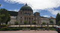
(19) Walk through the Kurgarten towards the cathedral.
(20) It’s definitely worth a visit. On leaving the cathedral, turn left again, back into the Kurgarten; there, turn right and walk through the “Hotel Klosterhof” building, over the “Latschari Bridge” onto “Hauptstraße”. There, turn right and walk through the town.
(21) When you reach the “St. Blasier Stüble” restaurant, keep left and continue along “Friedrichstraße”. Between house numbers 26 and 27, leave “Friedrichstraße” by turning left and follow the Albsteig signposts again.
(22) Cross the “Windbergbächle”, turn right and continue walking towards Häusern.
(23) At the junction with “Oberer Lehnernweg”, turn right. You’ll come to the road called “Zur Lehnern” and continue straight on until you reach “St.-Blasier-Straße” (L149); cross this road and carry on along the road called “Im Thauen”. Stay on this road until you reach the B500 main road.
(24) Do not cross it, but take the narrow path on the right running parallel to the B500, past the sports ground onto “Höchenschwanderstraße”. When you reach the Metallbau Ganzmann company, turn right and walk uphill towards Höchenschwand.
(25) You’ll arrive at the top of the “Im Lehen” ski lift, go under the B500 and continue along the “Kurpromenade” into Höchenschwand.
The final few metres take you along “St.-Georg-Straße” until you reach the “Dorfschmiede” restaurant, the end of this stage (E)
 Visorando Member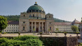
 Moderate
 Association / Club / Walk leader