Country:

 City:
City:


Car park near the Windeck ski run in Hinterzarten.
(S/E) Near the top of the ski run, turn right onto a path that leads into the forest. After about 1.5 km, you’ll reach Fürsatzplatz, a crossroads of paths.
(1) Take the path opposite, towards Rinken (follow the signs). From here, the path is almost flat, and mostly through the forest, until you reach the Jägerheim (described below). About 1.8 km after the Fürsatzplatz, you’ll reach the Lochrütte crossroads.
(2). Continue to follow the signs for “Rinken”. The path becomes a road leading to the Jägerheim inn (two houses side by side).
(3) Carry on to the junction where two roads meet.
(4) From here, the real climb begins. Follow the signs for the Baldenweger Hütte along a small tarmac road that climbs.
(5) Once you reach the Baldenweger Hütte, leave the tarmac behind for good. Take the path on the left which, after a few zigzags, leads to the summit of the Feldberg.
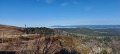
(6) From up there (alt. 1,495 m), on a clear day, you can see the whole of the southern Black Forest, the Vosges and even the Bavarian Alps. From here, the path is flat or downhill all the way to the end of the walk.
Head back down, following the ridge towards the Feldberg ski resort.
(7) At the resort, look out for the Seebuck-Hütte (the northernmost building, in a hollow at the foot of the chairlifts) and go round it to the right. Just after this (about 20 metres), the path has a fork in it. Take the left-hand path. This descends quite steeply towards the Feldsee glacial lake.
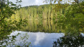
(8) A very beautiful spot. Walk along the right-hand side of the lake for about a quarter of a lap, then head eastwards away from it. 500 metres from the lake, you’ll pass the “Raimartihof” inn.
(9) Follow the signs for “Hinterzarten” along a path that runs almost entirely through woodland, with a few more open sections. About 4 km after the Raimartihof, you’ll reach the Fürsatzplatz crossroads you passed on the way out.
(1) From there, head down towards the starting point (S/E).

 Association / Club / Walk leader
 Moderate
 Visorando Member
 Easy
Easy