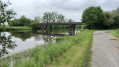
Bailey Bridge seen from Saint-Perreux

A pleasant route along the Oust and the Arz, ideal for anglers.

Details

7436792
Creation:
Last update:
Last review:
  • Walking
    Activity: Walking
  • ↔
    Distance: 5.64 mi
  • ◔
    Average duration: 2h 35 
  • ▲
    Difficulty: Easy

  • ⚐
    Back to start: Yes
  • ↗
    Ascent: + 20 ft
  • ↘
    Descent: - 16 ft

  • ▲
    Highest point: 39 ft
  • ▼
    Lowest point: 10 ft

Photos

Description of the walk

Park in the car park at the Saint-Perreux sports centre, Rue de la Mairie.

(S/E) From the car park, take the path leading to the River Oust and, once you reach the towpath, turn right to follow the river. Pass under the D164 bridge, then the railway bridge, and you will arrive at the River Arz.

(1) Turn right and follow the river upstream to the Pont du Quai.

(2) Cross the river, then turn left at the first road and keep left again to rejoin the path that runs alongside the river. At the end of the path, turn right and follow the Oust again until you reach the metal bridge, the Bailey Bridge.

(3) Cross the bridge and continue along the path to the old course of the River Oust.

(4) You’ll see the Redon racecourse on your left. Carry on to the Route des Marais.

(5) Turn left onto this road and head towards the Nantes–Brest Canal.

(6) Ignore the footbridge on the right, go under the railway line and continue along the canal until you reach the D164.

(7) Turn left onto the D164 and cross the canal and the River Oust.

(8) At the Vieille Draye crossroads, turn right, go under a power line and turn right again to return to the starting car park (S/E).

Waypoints

  1. S/E : mi 0 - alt. 20 ft - Car park at the sports hall, Rue de la Mairie
  2. 1 : mi 1.08 - alt. 10 ft - The - Oust (rivière)
  3. 2 : mi 1.59 - alt. 10 ft - Quay Bridge - Arz (rivière) - Affluent de l'Oust
  4. 3 : mi 3.26 - alt. 10 ft - Bailey Bridge
  5. 4 : mi 3.91 - alt. 13 ft - Hippodrome
  6. 5 : mi 4.11 - alt. 13 ft - Rue des Marais
  7. 6 : mi 4.51 - alt. 20 ft - Canal de Nantes à Brest
  8. 7 : mi 5.13 - alt. 26 ft - Road D164
  9. 8 : mi 5.47 - alt. 16 ft - The Old Draye
  10. S/E : mi 5.64 - alt. 23 ft - Car park at the sports hall, Rue de la Mairie

Worth a visit

A Bailey bridge is a portable prefabricated bridge, originally designed for military use and capable of spanning up to 60 metres. It requires neither special tools nor heavy equipment for its construction; its components are small enough to be transported by lorry, and the bridge is strong enough to allow tanks to cross. It is regarded as a model of military engineering.
__Donald Bailey (1901–1985) was a civil engineer at the Experimental Bridging Establishment¹, a military engineering organisation attached to the War Office (the British Ministry of Defence).

Reviews and comments

4.2 / 5
Based on 4 reviews

Reliability of the description
4.8 / 5
Ease of following the route
4.8 / 5
Route interest
3 / 5
Mumu06
Mumu06

Overall rating : 4.3 / 5

Date of your route : Jul 31, 2026
Reliability of the description : ★★★★★ Very good
Ease of following the route : ★★★★★ Very good
Route interest : ★★★☆☆ Average
Very busy route : No

A very pleasant walk, despite a few short stretches along the road. The scenery isn’t particularly varied, but the sections along the water are very lovely.

Machine-translated

BRUNUS76
BRUNUS76

Overall rating : 4.3 / 5

Date of your route : Aug 04, 2025
Reliability of the description : ★★★★★ Very good
Ease of following the route : ★★★★★ Very good
Route interest : ★★★☆☆ Average
Very busy route : No

Route with little shade (in strong sunlight)

Machine-translated

User 18663555

Overall rating : 3 / 5

Date of your route : Jul 30, 2025
Reliability of the description : ★★★★☆ Good
Ease of following the route : ★★★★☆ Good
Route interest : ★☆☆☆☆ Very disappointing
Very busy route : No

A boring and uninteresting route. Not to mention the proximity of the road at the start and end (very noisy) of the route. As for the "marshes", they are now meadows... and, for the most part, near the town, a vast disused car park. On closer inspection, this route is more suited to cyclists and fishermen along the Oust than to pedestrians.

Machine-translated

Christian35600
Christian35600

Overall rating : 5 / 5

Date of your route : Oct 09, 2023
Reliability of the description : ★★★★★ Very good
Ease of following the route : ★★★★★ Very good
Route interest : ★★★★★ Very good
Very busy route : No

Lovely walks along the western shore, very flat, with lovely views of the marshes

Machine-translated

Other walks in the area

For more walks, use our search engine .

The GPS track and description are the property of this route's author. Please do not copy them without permission.