Country:
 City:
City:


(Start) We set off from the car park of the Hotel & Landhaus Kastanie. From the car park, we turn right and then immediately left at the first junction. The path leads slightly downhill.
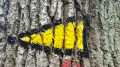
(1) The path takes us to the left, between two paddocks. Shortly afterwards, we reach the road, cross the Alster and turn right after the bridge. The path is marked with a yellow triangle with a black border.
(2) We follow the path and then turn right off the tarmac road (Schlickböge). A wooden sign reading ‘Alsterwanderweg’ indicates the way here.
(3) We cross the Alster again, cross Hanseatenweg and then follow the path to the left. We cross the Alster once more before reaching a campsite, which offers our first opportunity for a drink at the restaurant “Zum Haselknick”.
(4) We continue along the path, pass a fishing pond and then turn right, where the “Quellenhof” restaurant and beer garden offers the next opportunity to satisfy your hunger or quench your thirst.
(5) We walk past Rodenbeker Teich and then turn right. The signpost is hard to spot. The path leads down to the Alster, which we follow for a short while. We come to Twietenkoppel and turn right here, crossing the Alster. Before the bridge, there are a few places to sit and take a short break.
(6) After crossing the Alster, we follow the path to the left and, shortly afterwards, keep to the right and walk up the steps. Those looking for a bit of adventure can also take the path on the left through the bushes; this rejoins the main path a little further on.
(7) The path curves to the right and we reach Treudelberg. Here we turn left straight away and, shortly afterwards, left again to cross the Alster. Here you have another opportunity to stop for a bite to eat. The ‘Kleinhuis Mellingburg Schleuse’, with its garden terrace, offers a lovely spot for this.
(8) We reach Mellingburgredder. Between the last building and the car park, we turn right. There is no signpost at this point. Immediately afterwards, the path leads to the left, crossing the Alster once more and then continuing to the left along the river. We cross the bridge and continue to follow the Alster. At the end of Henneberg Park, we cross the Alster and walk along the lock pond.
(9) At the newly built Poppenbüttel lock, the path continues to the left. If you fancy it, you’ll have another chance here to stop for a coffee and a slice of cake at ‘The Locks’ on the other side of the lock. We cross a bridge and then the Saseler Damm before the path crosses the Alster once more. We keep to the left and continue to follow the Alster. In a park, we cross the Alster and then turn right.
(10) The route continues through the park. Almost at the end, a sign for the “Café im Herrenhaus” tempts you to veer off the path. You can give this detour a miss, as the café is currently closed indefinitely (as of May 2022). The path continues along the Alster until, opposite a sports ground, we cross the Alster again and then follow it further to the left.
(11) We pass two ponds, cross to the other side of the river again and continue to the right. Shortly afterwards, we cross another bridge and then turn left. At the next junction, we turn left and then left again, crossing the Alster. We head right through the Alsterpark, pass a sports ground and cross the railway tracks. We arrive at a pond, where the café ‘Zur Ratsmühle’, with its view of the Alster, invites you to take a break.
(12) We cross the Ratsmühledamm and, a little later, the street Am Hasenberge, before the path leads across the Alster once more. We continue to the right, then along Sengelmannstraße and Hindenburgerstraße. We reach the Alsterdorfer Damm and, shortly afterwards, cross the Skagerrak Canal. We then continue straight on for a short while, before turning right and then immediately left again.
(13) We cross the Deelböge Bridge and arrive at the underground station. Here, we turn left, then slightly right and left again. Via Bebelallee, we reach the Lattenkamp underground station. From here, you can head into the city centre or take the option of travelling back to the starting point (towards Ohlstedt and then onwards by bus. Further details can be found in the HVV app or online) (Destination).
 Visorando Member
 Moderate