Port du Pont de la Corde to Port de Penzé

This round-trip walk follows the Aber la Penzé, first along the higher ground and then closer to the river, allowing you to explore a valley shaped by the tides.

Details

n°68365445
Creation:
Last update:
Last review:
  • Walking
    Activity: Walking
  • ↔
    Distance: 9.48 mi
  • ◔
    Average duration: 4h 45 
  • ▲
    Difficulty: Moderate

  • ⚐
    Back to start: Yes
  • ↗
    Ascent: + 476 ft
  • ↘
    Descent: - 459 ft

  • ▲
    Highest point: 184 ft
  • ▼
    Lowest point: 10 ft
  • ⚐ Country: France
  • ⚐ City: Henvic (29670)
  • ⚑
    Start/End: N 48.643167° / W 3.948678°
  • ❏
    IGN map(s): Ref. 0515ET, 0615ET, 0616OT
  • Hour-by-hour weather

Description of the walk

Starting point at Port du Pont de la Corde, near the Sainte-Marguerite Chapel. Ample parking.

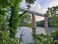
(S/E) From the harbour, take the south-southeast road that runs alongside Anse de Sainte-Marguerite, pass Pont ar Villin Goz (Pont du Vieux Moulin) and look for a path on the right.

(1) Follow this path and climb towards Keracoual.

(2) In the village, turn right, head towards the shore and you’ll reach a sea wall.

(3) At the end of the sea wall, take the path that climbs to the left and cross the level crossing.

(4) At the next junction, turn right and continue along a village track with views of Penzé. You’ll reach the hamlet of Kerandrez.

(5) At the road, turn right and head towards Lesnoa.

(6) Turn left, then, 200 metres further on, at the 90° left-hand bend, take the grassy path on your right which will lead you along a sunken track down to the river.

(7) At Milin Quistillic, ignore the path on the right – which will be the return route – and continue left until you reach a small path, 300 metres past the Quistillic Mill.

(8) Turn right and follow this path along the river to Port de Penzé.

(9) Turn back until you reach the Milin Quistillic junction.

(7) At the bottom of the sunken path, take a track opposite the steps leading to a meadow. Follow the meadow to reach a woodland that leads to the foreshore. Follow the river.

(10) Leave the foreshore and take a path at the foot of a wooded area to the embankment you have already walked along.

(3) Carry on straight ahead and retrace your steps along the route you took on the way out to return to Port du Pont de la Corde (S/E). 

Waypoints

  1. S/E : mi 0 - alt. 16 ft - Sainte-Marguerite Chapel
  2. 1 : mi 0.4 - alt. 36 ft - Pont ar Villin Goz (Old Mill Bridge) - Chapelle Sainte-Marguerite (Henvic)
  3. 2 : mi 0.69 - alt. 131 ft - Keracoual Bihan
  4. 3 : mi 1.17 - alt. 20 ft - Dike. Junction of the circular loop - Penzé (fleuve)
  5. 4 : mi 1.66 - alt. 154 ft - Level crossing
  6. 5 : mi 2.33 - alt. 184 ft - Kerandrez
  7. 6 : mi 2.67 - alt. 157 ft - Lesnoa
  8. 7 : mi 3.03 - alt. 30 ft - Milin Quistillic junction. Return to the harbour
  9. 8 : mi 3.2 - alt. 39 ft - Junction before Kervoaziou
  10. 9 : mi 4.91 - alt. 13 ft - Port de Penzé
  11. 10 : mi 7.34 - alt. 26 ft - Lower reaches of the river
  12. S/E : mi 9.48 - alt. 16 ft - Sainte-Marguerite Chapel

Notes

In winter, birds can be seen on the mudflats.
Red and yellow signposts guide you for half the route.

Worth a visit

Reviews and comments

3.7 / 5
Based on 2 reviews

Reliability of the description
3.5 / 5
Ease of following the route
4 / 5
Route interest
3.5 / 5
PYL
PYL

Hello

The route combines a return section and a circular section. This is mentioned in point 7, which is repeated twice in the text.
The circular section of this route runs along the foreshore, so it is best to do this part at low tide. Otherwise, return via the same route you took on the way there.

It is a good idea to take the bus from Morlaix, Saint Pol de Léon or Roscoff to return to the starting point.

Machine-translated

BOUGARAN
BOUGARAN

Overall rating : 3.3 / 5

Date of your route : Aug 21, 2025
Reliability of the description : ★★★☆☆ Average
Ease of following the route : ★★★☆☆ Average
Route interest : ★★★★☆ Good
Very busy route : No

We did this route in good weather and at high tide. It's a shame that the route description and the GPX file don't match. The GPX file sends us back along the edge of the Penzé (almost with our feet in the water), whereas the route description says to return via the same route as the outward journey. The route along the edge of the Penzé is tricky (muddy due to its proximity to the water, the start of the path is difficult to find, the path is not very visible in places, and trees obstruct the path). Blocked in our progress, we cut short by climbing an embankment and crossing a cornfield to find the "outward" route.
Fortunately, a beach bar was waiting for us at the port of Penzé to refresh us....

Machine-translated

mauricejeannine
mauricejeannine

Overall rating : 4 / 5

Date of your route : Sep 16, 2025
Reliability of the description : ★★★★☆ Good
Ease of following the route : ★★★★★ Very good
Route interest : ★★★☆☆ Average
Very busy route : No

At the starting point (S/E), after passing the Pont ar Villin Goz (Old Mill Bridge), find a path on the right: note that this path begins with a few steps and has a sign saying "Expo Penzé". This is a very narrow educational trail with signs here and there explaining the life of seaweed harvesters. It is complemented by an art exhibition.
Countryside and forest trail hike. La Penzé is rather muddy at low tide. Penzé is a countryside village with no particular attractions. As we were staying in Roscoff, we took the return bus at Pont de la Corde.

Machine-translated

Other walks in the area

For more walks, use our search engine .

The GPS track and description are the property of this route's author. Please do not copy them without permission.