Country:

 City:
City:



Access: Head towards the Col d’Izoard and Cervières via the D902. In Cervières, just after the entrance chicane, head up towards the higher part of the village by taking the first left at the junction, to join the D89T at the Church of Saint-Michel; this road will take you to Les Fonts de Cervières, the end point and car park where this hike begins.
(S/E) From the car park, walk past the mountain refuge and follow the path through the village of Les Fonts. Then cross the meadow to the south and the Pierre Rouge stream.
(1) At the signpost, turn right and head south onto theGR®58towards the Col de Péas. The path climbs diagonally and follows the course of the Cerveyrette stream.
(2) At the bridge, walk alongside the stream without crossing it, then head south up the grassy slopes for around 200 metres.
(3) Turn left and climb again up the grassy terraces heading east-southeast (azimuth 109°) for a straight-line distance of approximately 550m.
(4) Head east for about a hundred metres.
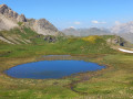
(5) Finally, head east-north-east (azimuth 77°), a direction you’ll need to maintain right up to the summit. You’ll emerge into the pastures on the Clot des Thures plateau, where it’s common to come across a few horses and herds of cattle coming to drink from the small lake. From there, you can see the summit and its western ridge.
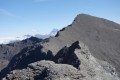
(6) Pass the Lac du Clot des Thures on the left and follow the ridge line to the summit. A narrow path and a few cairns will guide you on this final ascent. As you approach the summit, you’ll need to negotiate a steep section – a very easy climb with large holds and no exposure. Then, follow a narrow path to reach the summit cross and its box of surprises.
(7) Return in the opposite direction via the same route to the car park (S/E).


 Visorando Member
 Average
 Very difficult