Country:

 City:


It is fairly easy to park near Saint-Clément Church, on the left as you come down from the coast.
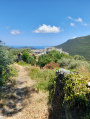
(S/E) Facing the cemetery, turn right and cross the D232 with care. Opposite, take the path that runs through the middle of some old gardens to reach Orneto via a flight of steps leading to the foot of a large fortified tower. Go round the lower side of the tower, then follow the road downhill for about fifty metres.
(1) Turn right, just below the retaining wall of the garden surrounding a very large house: the blue signposting is rather inconspicuous. Quite soon, the path winds through the undergrowth, with a small, restored fountain on the right. Continue along this path (which is sometimes quite rutted by wild boar) until you reach a cluster of houses. Turn left, then very quickly right to follow the narrow, sunken street leading towards the town hall. Behind the town hall, near the nursery school, go straight on along a path which, after a final bend to the left, joins the main road. Then turn right and continue uphill to cross the Ruisseau d’Olmo.
(2) Immediately afterwards, take the steps on the right, which lead onto a footpath. Return to the road and follow it to the right until you reach the hairpin bends about 300 metres further on. At the second bend, take the small road on the left, which quickly becomes a rather stony path leading down beneath the chestnut trees towards the valley floor.
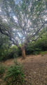
(3) Cross the magnificent Genoese bridge, with a large pool below that’s perfect for a swim: be careful, it’s deep. The walk then continues through the woodland, mainly along the valley floor at first and without difficulty, until you reach a spot which, when the streams are flowing, can be a little tricky: you’ll need to wade across over slippery stones – a rope has been put in place to help. Carry on through the scrubland along the steeply cut path that climbs the hill, then descends into woodland where there is a magnificent cork oak that’s not to be missed. You’ll reach a junction at a hairpin bend.
(4) Follow the path to the right carefully to head towards the village: a Blue Cross indicates that you should not take the path leading back to the tricky section via the valley floor. Following the path along the riverbank, you’ll reach the second Genoese bridge.
(5) The walk continues along the same bank and leads to the ford, 300 metres downstream. Cross the stream and then a very old olive grove to reach the foot of the bell tower at Saint-Clément (S/E).
 Visorando Member

 Moderate
 Difficult