Lézardrieux and the Trieux

Lézardrieux is situated on the left bank of the Trieux estuary, which, together with the Jaudy, forms the Pleubian peninsula. This extends into the English Channel via the Sillon de Talbert. Furthermore, with the town of Tréguier to the west, Pontrieux to the south and Paimpol to the east, Lézardrieux is the ideal base from which to explore this part of the Trégor region, close to the Île de Bréhat.
This route allows you to discover the Trieux with its lighthouses as well as the Chapel of Kermaria.

Details

583373
Creation:
Last update:
Last review:
  • Walking
    Activity: Walking
  • ↔
    Distance: 11.42 km
  • ◔
    Average duration: 3h 45 
  • ▲
    Difficulty: Moderate

  • ⚐
    Back to start: Yes
  • ↗
    Ascent: + 178 m
  • ↘
    Descent: - 174 m

  • ▲
    Highest point: 79 m
  • ▼
    Lowest point: 0 m
  • ⚐ Country: France
  • ⚐ District: Lézardrieux (22740)
  • ⚑
    Start/End: N 48.787873° / W 3.103088°
  • ❏
    IGN map(s): Ref. 0814OT, 0815SB
  • Hour-by-hour weather

Photos

Description of the walk

Lézardrieux harbour car park.

Red and white markings ofthe GR®34

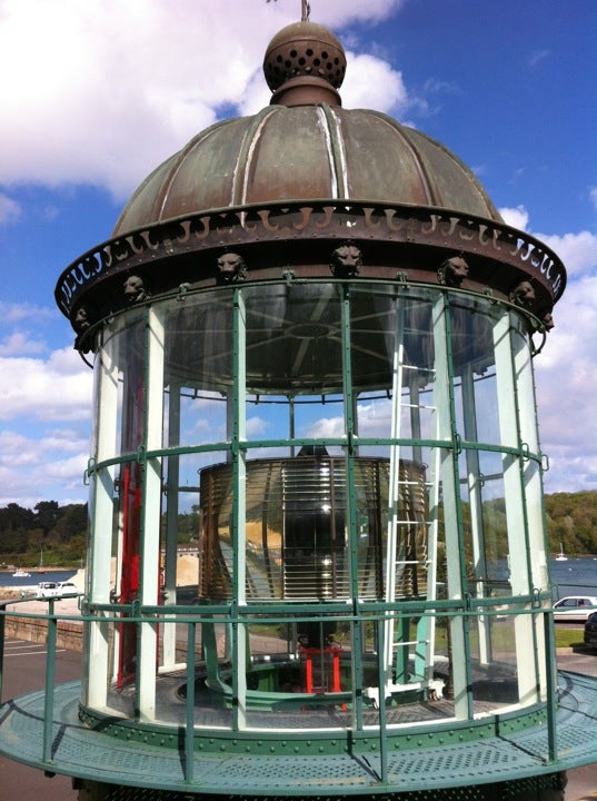
(S/E) Head north-east, keeping the harbour on your right, and make your way towards the harbour master’s office, recognisable by a lighthouse top with a lens at the entrance (see photo via the link below in the practical information section), then walk up Rue du Trieux.
Take the steps on the right leading down to the estuary and walk up Rue Georges Brassens (see note below).
Follow Rue de Trieux for 50m.

(1) Turn right onto Rue des Perdrix, then keep left heading north, ignoring the other paths branching off to the right.

(2) Continue straight ahead, crossing a stream, along the Discovery Trail. The path climbs and joins a road. Turn left, passing the Coatmer Amont lighthouse on your left.
Take the first path on the right, which runs alongside an oyster farm before joining a road.

(3) Turn left then right, towards the Moulin à Mer if the tide permits. (If not, refer to paragraph **)
Continue, passing a sign on your right reading “Ici se termine le Domaine public” (Public land ends here), and carry on through the rocks.
Turn left after fording a stream. The path, which is occasionally a little tricky, climbs up to a wash house.
After passing the wash house on your left, take the road to the right.

** At high tide, follow theGR®34alternative route, turning left onto Rue du Moulin à Mer then right twice to rejoin the route.

(4) At the T-junction, turn right and then left to cross the hamlet of Kerhamon.
After a bend to the right, then to the left, continue northwards to Prat.

(5) Turn right and follow the Chemin du Phare de Bodic. See below, in the practical information section, for the history of the Amer
In front of the lighthouse, take the path on the left and head towards the viewpoint.
(Author’s tip – rather than heading towards the viewpoint indicated on the right, carry on straight ahead and carefully make your way down the rocks a little: the view of the estuary will be more spectacular.)

(6) Turn back towards Prat.

No signposting

(5) Continue straight on.

(7) Cross the D20 road with care. Continue straight ahead along a wide path.
At the end of this, turn left and continue south, ignoring the turnings to the right and left.

(8) Turn left, then, after 50m, take the path on the right. It ends on Rue de Kervoas, which you follow to the right; after passing through the hamlet, take the path on the left.

(9) Continue straight ahead, then, at the end, turn left. Walk past the houses of Kermaria and turn right to walk alongside the chapel on your right.
At the T-junction, turn left and continue straight on at the Croaz-Hent crossroads.

(10) Take the road on the left. Then, after 150m, follow a path between two fields on the right. It bends first to the right then to the left. Continue, then turn left, heading east.

(11) Before reaching Rue de Kerilis, take the path on the right. Join Allée des Marronniers, which leads down towards the harbour. At the bottom of the descent, turn left to return to the car park where you started (S/E).

Waypoints

  1. S/E : km 0 - alt. 6 m - Lézardrieux harbour car park - Trieux (fleuve)
  2. 1 : km 0.81 - alt. 41 m - At the fork, turn sharp right
  3. 2 : km 1.58 - alt. 16 m - Straight ahead on the path
  4. 3 : km 2.34 - alt. 7 m - Road, on the left
  5. 4 : km 3.39 - alt. 59 m - Turn right
  6. 5 : km 3.98 - alt. 52 m - Junction for a return journey
  7. 6 : km 4.77 - alt. 34 m - 200° panoramic view
  8. 7 : km 5.99 - alt. 62 m - Crossing the D20
  9. 8 : km 7.83 - alt. 67 m - T-junction, turn left
  10. 9 : km 8.46 - alt. 68 m - At the bend, straight ahead
  11. 10 : km 9.93 - alt. 76 m - Turn left
  12. 11 : km 10.8 - alt. 51 m - Before the road, take the path on the right
  13. S/E : km 11.42 - alt. 6 m - Lézardrieux harbour car park

Notes

It’s a 1,600 km round trip to see the Amer and the Bodic lighthouse, as well as the panoramic view of the Trieux estuary.

Why is there a Rue Georges Brassens in Lézardrieux? Quite simply as a tribute to the singer who owned a white house with blue shutters there: “His haven of peace, far from the hustle and bustle of Sète”. There are no plaques or commemorations; the town still respects the artist’s “tranquillity” to this day.

Worth a visit

Always be cautious and plan ahead when you're outdoors. Visorando and the author of this route cannot be held responsible for any accidents occurring on this route.

The GR® and PR® markings are the intellectual property of the Fédération Française de Randonnée Pédestre.

Reviews and comments

4 / 5
Based on 6 reviews

Reliability of the description
4.3 / 5
Ease of following the route
4.2 / 5
Route interest
3.5 / 5
User 28742210

Overall rating : 4 / 5

Date of your route : Apr 02, 2026
Reliability of the description : ★★★★☆ Good
Ease of following the route : ★★★★☆ Good
Route interest : ★★★★☆ Good
Very busy route : Yes

A lovely walk along the banks of the Trieux from Lézardrieux to Loguivy-de-la-Mer. There are a few slightly steep sections for those unaccustomed to coastal paths (some fairly steep stairways leading up and down). Beautiful views of the harbour and the bridge at Lézardrieux.

Machine-translated

loti_33
loti_33

Overall rating : 3 / 5

Date of your route : Sep 01, 2025
Reliability of the description : ★★★☆☆ Average
Ease of following the route : ★★★★☆ Good
Route interest : ★★☆☆☆ Disappointing
Very busy route : No

It was high tide, so we had to take the GR 34 alternative (tarmac road) and when we reached the lighthouse, the path to Trieux no longer existed (private property with a barrier), so we had to take the road again. We returned through fields of corn and cabbages. Not very interesting overall. A shame

Machine-translated

kermarcmonique
kermarcmonique

Overall rating : 4.7 / 5

Date of your route : Jun 09, 2025
Reliability of the description : ★★★★★ Very good
Ease of following the route : ★★★★★ Very good
Route interest : ★★★★☆ Good
Very busy route : Yes

Only the elevation doesn't match Strava.

Machine-translated

randokergadic
randokergadic

Overall rating : 3.7 / 5

Date of your route : Nov 12, 2018
Reliability of the description : ★★★★☆ Good
Ease of following the route : ★★★☆☆ Average
Route interest : ★★★★☆ Good

The section under the Lézardrieux Bridge isn't easy to spot

Machine-translated

Géraud de BOISSET
Géraud de BOISSET

Overall rating : 4.3 / 5

Date of your route : Aug 31, 2018
Reliability of the description : ★★★★★ Very good
Ease of following the route : ★★★★★ Very good
Route interest : ★★★☆☆ Average

A 3-hour walk taken in late summer at high tide on a lovely sunny morning.
An easy route with clear instructions. A few lovely views of the River Trieux, though not as frequent as one might imagine. You walk along small tarmac roads and narrow sunken paths. The main points of interest are the port of Lezardrieux (and in particular the lighthouse lantern on display at the entrance to the lighthouses and beacons section), Bodic Lighthouse, Ker Maria Chapel and several beautifully restored farmhouses.

Machine-translated

pepelagratte
pepelagratte

Overall rating : 4.3 / 5

Date of your route : Aug 29, 2018
Reliability of the description : ★★★★★ Very good
Ease of following the route : ★★★★☆ Good
Route interest : ★★★★☆ Good

A lovely walk with no real difficulties; the coastal route is very pretty, pleasant and peaceful, with beautiful views of the estuary. My wife, my daughter and I did this walk at the end of August in fine weather; it took us three hours, including a picnic stop at midday. A lovely, relaxing time. Thank you for the walk.

Machine-translated

Other walks in the area

For more walks, use our search engine .

The GPS track and description are the property of this route's author. Please do not copy them without permission.