The Tossal Arrier circuit via the Ronesa path from Mesón Maigmo

An easy walk to get back into the swing of things or to enjoy with the family, mainly through woodland surrounded by beautiful peaks. The first part follows a quiet tarmac road and the return leg takes you along footpaths.

Details

n°66860558
Creation:
Last update:
Last review:
  • Walking
    Activity: Walking
  • ↔
    Distance: 4.97 mi
  • ◔
    Average duration: 2h 40 
  • ▲
    Difficulty: Easy

  • ⚐
    Back to start: Yes
  • ↗
    Ascent: + 476 ft
  • ↘
    Descent: - 476 ft

  • ▲
    Highest point: 2,142 ft
  • ▼
    Lowest point: 1,686 ft

Photos

Description of the walk

The starting point for this walk is in the car park at Mesón Maigmo.
To get to this starting point by car, see the ‘Practical Information’ section below.

(S/E) Head towards the tarmac road where you’ll see the sign for “Pantano de Tibi”. Follow the road.

(1) At the junction, follow the tarmac road to the right signposted “Pantano de Tibi”.

(2) Shortly afterwards, at the fork, follow the tarmac road to the left.

(3) Carry on, keeping the road on your right.

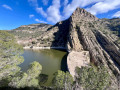
(4) Stunning view over the Barranc de Ronesa and Tibi Dam Lake. Keep to the right at the Fork in the road.

(5) The road leading to the Tibi Dam is closed. Take the dirt track on the right. Stay on this track, ignoring any side paths.

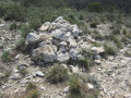
(6) At the multi-way junction, take the track on the left. Further on, take a moment to admire this beautiful stone refuge, part of whose roof has collapsed. Notice how the different stones are held together.

(7) Carry on straight ahead at the junction just after this. 200 m further on, continue along the path on the left. At the road, turn right and you’ll immediately come back to the junction you passed at the start of the walk.

(2) Turn left and follow the route back in the opposite direction to return to the car park (S/E).

Waypoints

  1. S/E : mi 0 - alt. 2,116 ft - Car park in front of Mesón Maigmo
  2. 1 : mi 0.47 - alt. 2,070 ft - Pantano
  3. 2 : mi 0.58 - alt. 2,054 ft - Crossroads on the circular loop
  4. 3 : mi 1 - alt. 1,985 ft - Junction
  5. 4 : mi 1.89 - alt. 1,765 ft - View
  6. 5 : mi 2.35 - alt. 1,686 ft - Road closed
  7. 6 : mi 3.73 - alt. 2,047 ft - Junction
  8. 7 : mi 4.03 - alt. 2,133 ft - Junction
  9. S/E : mi 4.97 - alt. 2,136 ft - Car park in front of Mesón Maigmo

Notes

To drive to the starting point of the walk.
From Alicante city centre, take the A31 motorway (from Calle Mexico) towards Madrid and, shortly afterwards, take exit 236A towards Benidorm and Valencia.
Then, shortly afterwards, take exit 17 towards Alcoï (or Alcoy). Once past the roundabout towards Alcoy, follow the A77 motorway, which becomes the A7.
Take exit 482 onto the CV-827 towards Agost.
Drive past the petrol station and park in the car park in front of Mesón Maigmo.

For your information, the journey by car from Alicante is 27 km and takes about 25 minutes.

Reviews and comments

4.7 / 5
Based on 1 review

Reliability of the description
5 / 5
Ease of following the route
4 / 5
Route interest
5 / 5
DLH
DLH

Overall rating : 4.7 / 5

Date of your route : Jan 13, 2025
Reliability of the description : ★★★★★ Very good
Ease of following the route : ★★★★☆ Good
Route interest : ★★★★★ Very good
Very busy route : No

I was surprised by the beauty of the scenery, given that the starting point didn’t look very promising. On the other hand, you can park easily and have a coffee or even lunch before or after the walk!
You need to be careful on the second part of the walk as there’s a whole network of small paths and it’s easy to take a wrong turn!

Machine-translated

Other walks in the area

For more walks, use our search engine .

The GPS track and description are the property of this route's author. Please do not copy them without permission.