Country:

 City:
City:


Free car park at Sénanque Abbey: one of the few spaces in the shade in the morning during summer is located exactly at the starting point of the GPX route.
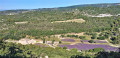
(S/E) Take the path leading to the monastery. Admire the buildings, the lavender and the whole site. Continue straight on, skirting the buildings on the left. You’ll emerge at the rear of the abbey; cross the Ruisseau de la Sénancole and go round the meditation area reserved for the monks.
(1) At the Fork in the road, ignore the path leading off to the left into the Gorges de la Sénancole and continue straight up. Further on, you can carry on straight ahead or turn right, but be careful not to head north.
(2) Pass the Maquisards’ farm on your right and take the path on the left. From here, the path begins to be marked with a yellow line. Follow this marked path exactly as indicated, reach the Sénancole stream and cross it.
(3) Turn right at the junction, following the yellow markings, and cross the stream several times.
(4) Climb the path on the left and reach the signposted junction: La Sénancole.
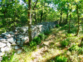
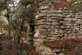
(5) Take the path on the right towards the Village of Drystone Shelters.
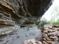
(6) Pass by a cave that was converted during the Second World War into a refuge for resistance fighters fleeing the enemy. Arrive at the Village des Bories.
(7) Follow the signposted route to the right towards Les Grangiers and turn sharply right 100 metres further on. The track becomes a footpath and joins the GR® de Pays Tour des Monts de Vaucluse: marked in yellow and red.
(8) Take this path to the left and head more or less straight on towards Gordes until you reach the hamlet of Bel-Air.
(9) Cross the Route des Moines (D15) and take the Chemin de Bel-Air opposite, continuing down to the lower part of Gordes. Then turn right onto Rue Jean Deyrolle and continue to the hairpin bend, where there is a small car park.
(10) Take the street on the right for a short, unmissable stroll through the narrow streets of Gordes. You’ll soon reach the Théâtre des Terrasses.
(11) Continue along Rue André Lhote, then take the steps on the left to reach Rue Baptistin Pica. Walk about twenty metres to the left, then turn right to reach Place du Château.
(12) Then head towards the Église Saint-Firmin.
(13) Walk round the church on the right, return to the path leading to the Théâtre des Terrasses that you took earlier, and take the street on the right to return to the hairpin bend.
(10) Walk up Rue des Tanneurs, continue straight ahead along Rue de la Combe (D15) and take the left-hand bend at the police station.
(14) Take the alleyway on the right, which leads onto the Route de Sénanque (D177), and follow it to the right until you reach the junction with the Chemin des Dilais.
(15) Turn left and continue along this small road, which then becomes a track, until you reach the Gorges de la Sénancole.
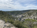
(16) Take the path to the right which runs along the top of the gorges and rejoins the Route de Sénanque at the Côte de Sénancole.
(17) Follow the road to the left and, 100 metres further on, turn left onto the rocky, downhill path which leads back to the car park (S/E).

 Visorando Member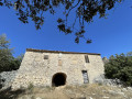

 Difficult
  Easy
Easy