Country:

 City:
City:


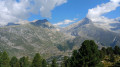
Hike completed by the author on 29 July 2026
This hike starts and finishes at the Bettmeralp Bergstation.
- Before setting off, it is advisable to check the Suisse Topo website for any trail closures and diversions. This information is updated in real time.
- As well as the Visorando app, you can also download the free swisstopo app, where you’ll find this information too.
Transport: Timetables
Weather: before setting off, check the Swiss Weather Service or Météo Blue
Hiking equipment, particularly good walking boots.
 Visorando Member

 Average