The Biracois Fifteen

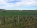
A long walk that will take you through the sweeping landscapes around Birac. Lots of vineyards, but also other crops and livestock farming.

Details

n°241666
Creation:
Last update:
Last review:
  • Walking
    Activity: Walking
  • ↔
    Distance: 9.26 mi
  • ◔
    Average duration: 4h 30 
  • ▲
    Difficulty: Moderate

  • ⚐
    Back to start: Yes
  • ↗
    Ascent: + 308 ft
  • ↘
    Descent: - 305 ft

  • ▲
    Highest point: 335 ft
  • ▼
    Lowest point: 161 ft
  • ⚐ Country: France
  • ⚐ City: Birac (16120)
  • ⚑
    Start/End: N 45.559917° / W 0.062915°
  • ❏
    IGN map(s): Ref. 1632SB
  • Hour-by-hour weather

Photos

Description of the walk

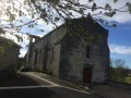
(S/E) Starting from the car park opposite the town hall, walk between the town hall and the church. The small street takes you round a right-angle bend to the left. Go downhill and then back up the road opposite, taking the small street on the right.

(1) Cross the D14 and take the grassy path opposite. Cross a small tarmac road and, still heading straight ahead, continue along the path running beneath a power line. Carry on in this direction until you reach Les Rentes.

(2) You’ll come to a short stretch of tarmac; turn right onto the small road leading downhill. At the junction, take the path straight ahead that leads uphill. Walk alongside a small copse, then head back downhill. At the crossroads, turn left; the path is occasionally lined with a small hedge.

(3) Before reaching the road (at a hedge), turn right onto a barely marked path between fields. Continue in this direction until you come to a good path on the right, which you should take.

(4) Pass by a farm with cows, keep going straight on, cross the D14 again and enter La Gallacherie.

(5) At a chestnut tree, turn left onto a small street which turns into a track. Walk alongside a few trees; a track coming from the left joins the one you’re on – carry on straight ahead towards the buildings. Do not go right up to them, but turn sharply right and carry on straight ahead.

(6) Cross a small road and carry on straight ahead along the correct track. At the next junction of tracks, turn left. Cross a small road and carry on straight ahead, passing under two power lines until you reach La Croix Nouveau.

(7) Cross the D10 (take care) and turn into the small street on the left. Continue in this direction along the track, turning right when the track passes under the power line. Head down this track through the vineyards, then go straight up the other side. Ignore the first track coming from the left.

(8) At the crossroads, turn right and, fifty metres further on, turn right again onto a barely marked path, heading towards a small copse. Walk through the copse and continue in the same direction. Pass under the power line and turn left into the hedge.

(9) Cross the D10 (take care) and take the path opposite, which is barely marked at the start. Follow it along the hedge until you reach Bussac. Cross this hamlet, carry on straight ahead, rejoin the tarmac road and then leave it to follow a good path. Pass by three beautiful cherry trees, then under Les Petites Bouries, and reach a small road.

(10) Turn right, then turn right again to reach Les Bouries. Keep to the left and continue straight ahead along the path when you reach a small road. Pass under the power line, first turn right then left to follow a grassy path under a small power line. You’ll come to a road again; turn right. After a few hundred metres, the car park comes into view (S/E).


Waypoints

  1. S/E : mi 0 - alt. 220 ft - Car park opposite the church
  2. 1 : mi 0.22 - alt. 223 ft - Cross the D14, then continue straight ahead
  3. 2 : mi 0.74 - alt. 217 ft - Les Rentes, turn right
  4. 3 : mi 1.71 - alt. 171 ft - Hedge, turn right
  5. 4 : mi 2.6 - alt. 230 ft - Cattle farm
  6. 5 : mi 2.97 - alt. 266 ft - Large chestnut tree, turn left
  7. 6 : mi 4.07 - alt. 282 ft - Cross a small road, then continue straight ahead
  8. 7 : mi 5.03 - alt. 236 ft - D10, cross over and head slightly to the left
  9. 8 : mi 6.19 - alt. 220 ft - Crossroads, turn right
  10. 9 : mi 6.97 - alt. 217 ft - D10, opposite, poorly marked path
  11. 10 : mi 8.09 - alt. 305 ft - Road, turn right
  12. S/E : mi 9.26 - alt. 220 ft - Car park opposite the church

Reviews and comments

3.2 / 5
Based on 4 reviews

Reliability of the description
3.3 / 5
Ease of following the route
3.5 / 5
Route interest
2.8 / 5
16Patoche
16Patoche

Overall rating : 3.7 / 5

Date of your route : Feb 20, 2022
Reliability of the description : ★★★★☆ Good
Ease of following the route : ★★★★☆ Good
Route interest : ★★★☆☆ Average
Very busy route : No

For your information, the section between numbers 9 and 10 is now passable; the path, which had indeed been ploughed up for a while, has been restored to use by the farmer. There are therefore no longer any difficulties on this route.

Machine-translated

gazok54
gazok54 ★

Thank you, jeanclaudelafon
Could you tell me where the ploughed field is? I imagine the path has disappeared and we’ll have to go round the field?

Machine-translated

jeanclaudelafon
jeanclaudelafon

Overall rating : 3.3 / 5

Date of your route : Jan 26, 2017
Reliability of the description : ★★★☆☆ Average
Ease of following the route : ★★★★☆ Good
Route interest : ★★★☆☆ Average

We walked eleven kilometres instead of the fourteen suggested; there were no particular problems – it was a pleasant walk in scenery made all the more beautiful by a lovely frost on a January morning. Part of the land had practically been ploughed by the farmer.

Machine-translated

bibi
bibi ★

Thank you for this feedback from the field – does this cover the entire section from 9 to 10, or just from point 9 to Bussac?
I was the one who mapped out this route for the community of communes, and I’d pointed out that the farmer was in the process of taking over this path… has he managed to do so completely?
Kind regards

Machine-translated

rouleracheval
rouleracheval

Overall rating : 1 / 5

Date of your route : Dec 16, 2016
Reliability of the description : ★☆☆☆☆ Very disappointing
Ease of following the route : ★☆☆☆☆ Very disappointing
Route interest : ★☆☆☆☆ Very disappointing

Between points 9 and 10, the path has been ploughed up, sown over, and has finally disappeared completely and become impassable...

Machine-translated

bibi
bibi ★

Hello, and thank you for your comment. I spotted this route last June, and it’s true that the path was poorly marked between points 8 and 9, but it was mainly between points 9 and 10 that a section had disappeared…
Thank you in any case for this feedback on the walk.

Machine-translated

29MCSTT12ZYW4804AHP2

Overall rating : 4.7 / 5

Date of your route : Aug 09, 2016
Reliability of the description : ★★★★★ Very good
Ease of following the route : ★★★★★ Very good
Route interest : ★★★★☆ Good

A lovely walk, slightly undulating, which offers some panoramic views.
The countryside is dotted with vineyards and various crops, as well as livestock farms. There are no signposts along the route, but
as there is a clear route marked on the map and a good description, you’ll manage just fine.
A minor point: the path between points 8 and 9 needs reviewing (some sections are missing).

Machine-translated

Other walks in the area

For more walks, use our search engine .

The GPS track and description are the property of this route's author. Please do not copy them without permission.