The Polissoir of the Saint-Martin Well

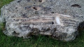
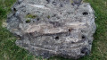
The main aim of this short walk, which alternates between paths through the fields and through the village of Corancez, is to discover a particularly large Neolithic grinding stone.

Details

1274503
Creation:
Last update:
Last review:
  • Walking
    Activity: Walking
  • ↔
    Distance: 2.50 mi
  • ◔
    Average duration: 1h 10 
  • ▲
    Difficulty: Easy

  • ⚐
    Back to start: Yes
  • ↗
    Ascent: + 13 ft
  • ↘
    Descent: - 13 ft

  • ▲
    Highest point: 466 ft
  • ▼
    Lowest point: 443 ft
  • ⚐ Country: France
  • ⚐ City: Corancez (28630)
  • ⚑
    Start/End: N 48.368001° / E 1.51824°
  • ❏
    IGN map(s): Ref. 2117SB
  • Hour-by-hour weather

Photos

Description of the walk

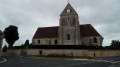
Start from Corancez church. Park in the car park behind the church (as seen from the D28), near a small football pitch and a playground.

(S/E) From the car park, facing the church, follow Rue de la Baguetterie straight ahead, keeping the church on your left.

(1) At the roundabout, take thesecond left onto Rue de la Mairie. The street passes in front of the town hall and curves to the right. When it turns sharply to the right and becomes Rue du Général Bouvart, leave it and continue straight on (south) along a track that runs between the fields (fire hydrant on the right-hand side). Turn right along the track and you’ll come out onto a small road.

(2) Follow the road to the left for about a hundred metres. At a slight left-hand bend, leave the road and turn right onto a wide track between the fields. Pass a crib (a structure for drying maize cobs in the open air) on your right and reach the edge of a wood.

(3) Turn left onto the path, then veer right to cross the woodland quickly. At the other end, turn left and, on a grassy path, walk alongside the woodland on your left. At the end (with livestock buildings opposite), turn left. Join the road again and follow it to the right for about 150 metres.

(4) When you reach the first livestock buildings, take the grassy path on the left that leads to the polishing stone (sign). Retrace your steps.

(4) Turn right. Follow the small, quiet road, ignoring the two paths on the left that you took on the way there.

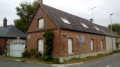
(2) At the junction, carry on straight ahead along the road and enter the village of Corancez. At the crossroads, go straight on into Rue du Polissoir. Note a pond on the right-hand side. At the next crossroads, turn right into Rue Saint-Laurent (D28 towards Sours).

(1) At the roundabout, take the first left, Rue de la Baguetterie, and return to the car park (S/E).

Waypoints

  1. S/E : mi 0 - alt. 456 ft - Car park - Église Saint-Laurent (Corancez)
  2. 1 : mi 0.07 - alt. 449 ft - Roundabout
  3. 2 : mi 0.58 - alt. 463 ft - Junction of the D150 road and the track
  4. 3 : mi 0.92 - alt. 446 ft - Edge of the woods
  5. 4 : mi 1.37 - alt. 456 ft - Access to the - Polissoir du Puits de Saint-Martin
  6. S/E : mi 2.5 - alt. 456 ft - Car park - Église Saint-Laurent (Corancez)

Notes

A good pair of trainers is sufficient for this walk along small tarmac roads or good footpaths.

Water source between Corancez church and the crossroads (1). No shops in Corancez.

A detailed map is required (at the very least, the one accompanying this description).

Alternative return route:
If you prefer to avoid tarmac, at point (4), you can always return to Corantez via the same route as on the way out, i.e. via point (3).

Hike completed by the author on 11 July 2018.

Worth a visit

The Polissoir du Puits de Saint-Martin (4) is the destination of this walk. It is a large slab of sandstone (5.3m x 2.2m) covered with numerous deep grooves, which bear witness to the stone’s use during the Neolithic period (5000–2500 BC) for polishing and sharpening weapons and tools. The stone features a central depression which collects rainwater, giving the polishing stone its name.

The Church of Saint-Laurent (12th–18th centuries) (S/E) is well worth a visit. In particular, you can take a stroll around the small adjoining cemetery.

Reviews and comments

4.7 / 5
Based on 2 reviews

Reliability of the description
5 / 5
Ease of following the route
5 / 5
Route interest
4 / 5
seb-elise
seb-elise

Overall rating : 5 / 5

Date of your route : Apr 30, 2019
Reliability of the description : ★★★★★ Very good
Ease of following the route : ★★★★★ Very good
Route interest : ★★★★★ Very good

Very detailed description. A walk suitable for children. Discovering the ‘polissoir’ right in the middle of the Beauce region’s intensive farming landscape (with the stinking rapeseed in bloom) is a surprise.
Apart from that, it’s just the Beauce region...

Machine-translated

momo45
momo45

Overall rating : 4.3 / 5

Date of your route : Apr 01, 2019
Reliability of the description : ★★★★★ Very good
Ease of following the route : ★★★★★ Very good
Route interest : ★★★☆☆ Average

A very well-described route.
A short, easy walk near Courancez, offering the chance to see an archaeological curiosity you’d never have suspected was there, as it’s hidden away in the fields.

Machine-translated

Other walks in the area

For more walks, use our search engine .

The GPS track and description are the property of this route's author. Please do not copy them without permission.