The leisure trail along the old tracks

Route closed by municipal order dated 9 July 2026.

Marked walk No. 12.
A route themed around recreational sport, following a section of an old railway line and a section of an ancient Roman road, with some wonderful heritage sites to discover.

Details

204886
Creation:
Last update:
Last review:
  • Walking
    Activity: Walking
  • ↔
    Distance: 8.08 mi
  • ◔
    Average duration: 4h 00 
  • ▲
    Difficulty: Moderate

  • ⚐
    Back to start: Yes
  • ↗
    Ascent: + 371 ft
  • ↘
    Descent: - 390 ft

  • ▲
    Highest point: 958 ft
  • ▼
    Lowest point: 659 ft

Description of the walk

The start of this route is in the hamlet of Pesselière (in the commune of Sougères-en-Puisaye), from the Champ de Foire car park, very close to the sawmill.

(S/E) Head due east along the street leading towards Les Roches.

(1) Walk past Les Cèdres de la Lavière (on your left) and continue to the junction where there is a wayside cross on the left.

(2) Take the street opposite, then turn onto the first path on the left; you’ll soon reach a junction on the right.

(3) Take this path; when you reach a wide track (an old railway line), turn left and follow it to the junction with the cross-street known as Rue des Simoneaux.

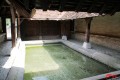
(4) Head down to the right, passing the rather unusual wash house. Continue along the route, turning left into the first street and walking for about 150 metres. At the crossroads, turn left to reach a former gatekeeper’s cottage on the left.

(5) Opposite this, take the grassy path, which is the old railway line you left at the washhouse. Continue to the next crossroads without leaving this main route.

(6) Then turn left to take the Chemin des Romains (also known as the Ancienne Voie Romaine). You’ll come out onto a road.

(7) Cross this road and take the path leading into the woodland. Turn left at the second path on your left. Continue straight on, passing some outdoor fitness equipment, and exit the woodland.

(8) After 200 m along this stretch between the woodland edge and the field, enter the woodland again on the left, pass the fitness equipment along the trail and arrive at a picnic table on your left. Turn immediately right and come out onto a small road. Take this road to the left to reach the junction of the cross-country paths.

(9) Continue along the path branching off to the right, which is once again the Roman road. It leads out onto a road.

(10) Turn left and follow this for about 600 metres.

(11) Leave this road and turn right at a point where the path is not clearly marked; however, on the sloping field, a hedge on your right and a copse on your left, slightly lower down, will point you in the right direction. At the bottom of this fairly short stretch, a path branches off to the left. Follow this path, keeping the edge of the woodland on your left. A short climb takes you out of the valley and onto a crossroads.

(12) Turn left, then 100 m further on, turn right into Rue du Tilleul. Continue straight on along this road. Pass in front of the Tilleul de Sully.

(13) Turn slightly to the right. Cut across the crossroads to reach the Place du Champ de Foire (S/E).

Waypoints

  1. S/E : mi 0 - alt. 823 ft - Place du Champ de Foire
  2. 1 : mi 0.64 - alt. 768 ft - Cèdres de la Lavière
  3. 2 : mi 1.42 - alt. 696 ft - Calvary on the left
  4. 3 : mi 1.71 - alt. 659 ft - Turn off to the right
  5. 4 : mi 3.19 - alt. 699 ft - Road and wash house shortly afterwards
  6. 5 : mi 3.35 - alt. 696 ft - Follow the old railway line
  7. 6 : mi 4.2 - alt. 725 ft - Turn left onto the old Roman road
  8. 7 : mi 4.74 - alt. 814 ft - Enter the woodland
  9. 8 : mi 5.44 - alt. 912 ft - Head back into the woodland
  10. 9 : mi 5.91 - alt. 883 ft - Roman Road
  11. 10 : mi 6.73 - alt. 751 ft - End of the Roman road
  12. 11 : mi 7 - alt. 778 ft - Path on the right is poorly signposted
  13. 12 : mi 7.8 - alt. 778 ft - Turn right for a few metres
  14. 13 : mi 8 - alt. 820 ft - Tilleul de Sully de Pesselières
  15. S/E : mi 8.08 - alt. 823 ft - Place du Champ de Foire

Notes

This route is suitable for mountain bikes, provided you show consideration for walkers and families using the recreational trail.
Make sure you wear a hat and sunglasses, as many sections are exposed to the sun.
There is no drinking water on this route.
Picnic tables along the route (S/E), (2), .
Between (S/E) and (2), you will come across signposts marked with numbers 10 and 11. Ignore these; this path is signposted towards the village of Sougères-en-Puisaye or Druyes-les-Belles-Fontaines.
It is entirely possible to walk from this route to the one in Druyes – see this walk.
This route, signposted in accordance with the signposting guidelines of the Puisaye-Forterre Community of Communes, is marked with the number 12 on yellow-backed plaques. It was created by the association ‘À chacun son chemin en Puisaye-Forterre’ in January 2020.
If you encounter any issues, please complete this questionnaire (it only takes 1 to 2 minutes).
Please take care when crossing roads.

Worth a visit

Very close to Pesselière lies the village of Druyes-les-Belles-Fontaines. Don’t miss the Sources de la Druyes, the fortified castle and a few art galleries. At the foot of the springs, there’s an open-air café in the warmer months.
It is entirely possible to walk from this route to the one in Druyes.

Reviews and comments

4.4 / 5
Based on 3 reviews

Reliability of the description
5 / 5
Ease of following the route
4.7 / 5
Route interest
3.7 / 5
User 3740499

Overall rating : 4.3 / 5

Date of your route : Aug 22, 2025
Reliability of the description : ★★★★★ Very good
Ease of following the route : ★★★★☆ Good
Route interest : ★★★★☆ Good
Very busy route : No

Thank you for this beautiful route, which is very well explained
It is almost entirely marked with the number 12
Only the section between 11 and 12 is a little confusing and, unfortunately, there are no signs

Machine-translated

FGN
FGN

Overall rating : 4.3 / 5

Date of your route : Sep 29, 2021
Reliability of the description : ★★★★★ Very good
Ease of following the route : ★★★★★ Very good
Route interest : ★★★☆☆ Average
Very busy route : No

The route is a bit dreary as there are long, uninteresting stretches, despite the magnificent cedars of La Lavière, the Simoneaux washhouse and the Sully lime tree at the finish. Admittedly, the old railway line and the Roman road are worth seeing, but it does get monotonous towards the end. The section through the forest (points 7 and 8) is interesting, as is the final stretch between points 9 and 12. The signposting is perfect. (Shhh! We’ve been asked not to mention it!)

Machine-translated

adriendufourbussy
adriendufourbussy

Overall rating : 4.7 / 5

Date of your route : Apr 24, 2019
Reliability of the description : ★★★★★ Very good
Ease of following the route : ★★★★★ Very good
Route interest : ★★★★☆ Good

A walk through varied countryside (fields, an old railway line, historic villages, woodland)
A pleasant, varied and signposted route (no need to carry a map with you at all times).
As the route is fairly flat, keen walkers won’t take 4 hours (more like 3).
There’s a short stretch along a road at the start, but no traffic
On a sunny day, this route lets you enjoy a variety of scenery whilst making the most of the great outdoors without any difficulty.

Machine-translated

Other walks in the area

For more walks, use our search engine .

The GPS track and description are the property of this route's author. Please do not copy them without permission.