Country:
 City:
City:


From the centre of Saint-Jouan-des-Guérets, take Rue du Moulin de Quinard (signposted) to the banks of the Rance maritime (small car park).
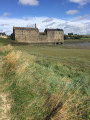
(S/E) The imposing structure of the mill stands out; whilst the buildings remain intact, the hydraulic system feeding the tidal basin, the dyke and the reservoir have disappeared beneath the silt.
Turn right onto the path that runs along the shoreline and, at Pointe du Grouin, take the steps leading up to the plateau. The path follows the contour line across the plateau, before descending to Plage du Vallon with its boat launch ramp. You must then take the coastal road and, at the end, return to the foreshore.
(1) You must take the steps on the right as it is no longer possible to follow the shore, even at low tide. Make your way to Pointe de la Roche du Port.
(2) Continue along the well-marked path which overlooks the Rance from a considerable height; caution is advised, especially if the ground is slippery.
(3) At Saint-Elier, the path descends to the foreshore. Depending on the tide, continue along the foreshore or take the stone pavement at the foot of the wall belonging to the riverside property. In the event of flooding, a sign indicates the route to take inland.
(4) Leave the foreshore and take the path behind the hut, on the left. It runs along the top of the cliff and leads to Anse de Quelmer.
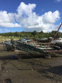
(5) In Anse de Quelmer, on the foreshore of a former shipyard, lie several dozen old boat hulls of all types, their frames exposed to the elements. This is the only boat graveyard in Brittany.
The return journey follows the same route back to the tide mill (S/E).

 Association / Club / Walk leader
 Easy
Easy 
 Visorando Member