The Drachensee via the Seebensee

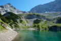
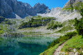
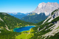
In the heart of the Wetterstein, a mountain range in the northern Eastern Pre-Alps straddling the border between Austria and Germany, this hike will take you past two stunning mountain lakes.
The climb up to the Drachensee is steep, and you can stop off at the Seebensee.

Details

2330434
Creation:
Last update:
Last review:
  • Walking
    Activity: Walking
  • ↔
    Distance: 8.24 mi
  • ◔
    Average duration: 5h 20 
  • ▲
    Difficulty: Moderate

  • ⚐
    Back to start: Yes
  • ↗
    Ascent: + 1,798 ft
  • ↘
    Descent: - 1,772 ft

  • ▲
    Highest point: 6,270 ft
  • ▼
    Lowest point: 4,921 ft

Photos

Description of the walk

Start from the top station of the cable car (Bergstation: see the practical information section).

(S) From the top station of the cable car, follow the signposts visible on a wide track below on the right. Turn left onto the wide track towards Seebensee (signposted as a 2-hour walk via trail no. 34). At each junction, continue along the wide track towards Seebensee, first heading south-east and then south-west.

(1) At a fork in the road by a barrier, turn left onto the path (no cycling allowed), which continues through the woodland.

(2) Further on, follow the signpost advising you to carry on straight ahead along the main path and ignore the track leading uphill to the left. Further on, at another junction, carry on straight ahead towards Coburger Hütte. Continue westwards.

(3) At the fork in the road (signposts attached to a tree slightly above the path), take the left-hand path towards Seebensee. Further on, ignore a few paths branching off to the right and you’ll reach the Seeben Alm mountain hut.

(4) Pass above the hut (to the south of it) and continue along the main path.

(5) At a Fork in the road, turn left and head towards Lake Seebensee.

(6) Walk round the lake on the left, towards the Coburger Hütte. The path moves away from the lake and crosses (south-south-west) the mountain pastures.

(7) Continue southwards and climb the steep switchbacks. This will take you to the mountain hut (Coburger Hütte).

(8) Leave the mountain hut on your right and turn left to reach the Drachensee below.

(9) Return via the same route to the top station of the cable car (S/E).

Waypoints

  1. S/E : mi 0 - alt. 4,921 ft - Mountain station
  2. 1 : mi 1.41 - alt. 5,217 ft - Junction of footpaths and mountain bike trails
  3. 2 : mi 1.6 - alt. 5,203 ft - Junction
  4. 3 : mi 2.19 - alt. 5,240 ft - Fork in the road
  5. 4 : mi 2.71 - alt. 5,187 ft - Seeben Alm mountain hut
  6. 5 : mi 2.98 - alt. 5,397 ft - Fork in the road
  7. 6 : mi 3.13 - alt. 5,456 ft - Lac Seebensee
  8. 7 : mi 3.56 - alt. 5,581 ft - Start of the climb to the mountain hut
  9. 8 : mi 3.95 - alt. 6,270 ft - Coburger Hutte
  10. 9 : mi 4.09 - alt. 6,171 ft - Lac Drachensee
  11. S/E : mi 8.24 - alt. 4,921 ft - Mountain station

Notes

To reach the start of the hike, take the cable car from the Ehrvalder Almbahn station (€17.50 per person, return) which takes you to the top station (Bergstation).

Always bring water, a cap and sun cream. Even if the sky is overcast, it can clear very quickly in the mountains.

You can have a drink or a bite to eat at the Seeben Alm or the Coburger Hutte. Make sure you bring cash as credit cards are not accepted.

Dogs are allowed but must be kept on a lead throughout the trail.

You’ll find toilets at the Coburger Hutte.

Worth a visit

You can walk all the way round the Drachensee, or you can reach the cable car via another lake, the Brendlsee. This will add over 300 metres of elevation gain. You can actually see the path climbing eastwards, above the Drachensee.

Reviews and comments

5 / 5
Based on 2 reviews

Reliability of the description
5 / 5
Ease of following the route
5 / 5
Route interest
5 / 5
EmmaMahdis
EmmaMahdis

Overall rating : 5 / 5

Date of your route : Aug 16, 2024
Reliability of the description : ★★★★★ Very good
Ease of following the route : ★★★★★ Very good
Route interest : ★★★★★ Very good
Very busy route : Yes

Magnificent hike, very easy to follow, everything is signposted and the path is quite busy.
The first lake is easy to get to, but the second requires a lot of physical effort because of the difference in altitude, but it's absolutely worth it.
At the second lake there is a restaurant/auberge offering excellent food and desert (reward for the effort!).

Machine-translated

nicoboudry
nicoboudry

Overall rating : 5 / 5

Date of your route : Aug 19, 2024
Reliability of the description : ★★★★★ Very good
Ease of following the route : ★★★★★ Very good
Route interest : ★★★★★ Very good
Very busy route : Yes

Very nice hike I did with my son on 15/08. It's in 2 parts: the first is very easy to get to, but the second to get to the 2nd lake is quite a climb. Access to the first lake by electric bike is a little too crowded, but it's still a very beautiful spot.

Machine-translated

Other walks in the area

For more walks, use our search engine .

The GPS track and description are the property of this route's author. Please do not copy them without permission.