Bassin Long and Ravine Divon

The Saint-Paul area comprises three main basins: Bassin Vital, Bassin Long and Bassin Pigeon. The latter is the easiest to access and is situated in Ravine Divon. The ravine has changed its name several times. Its first name was Ravine d’Hibon, in honour of a landowner nearby, then Ravine d’Yvon and finally Ravine Divon. The walk to the pond is suitable for families and never difficult, with a few spots that are ideal for a picnic.

Details

n°2768213
Creation:
Last update:
Last review:
  • Walking
    Activity: Walking
  • ↔
    Distance: 1.08 mi
  • ◔
    Average duration: 0h 35 
  • ▲
    Difficulty: Easy

  • ⚐
    Back to start: Yes
  • ↗
    Ascent: + 85 ft
  • ↘
    Descent: - 85 ft

  • ▲
    Highest point: 102 ft
  • ▼
    Lowest point: 13 ft

Description of the walk

Access:
From Saint-Pierre: follow the Route des Tamarins to Saint-Paul and take the first exit. Go under the A-road and take the first left onto the Chaussée Royale. Then take the first left towards Grande Fontaine, go under the bridge and take the first left towards Tour des Roches. Follow the road to the first footbridge on the right.

From Saint-Denis: head towards Saint-Paul via the N1. After passing the Étang de Saint-Paul, take the next exit. At the traffic lights, keep left onto the Chaussée Royale and follow this road before taking the second left; go under the bridge and then take the first left towards the Tour des Roches. Follow the road to the first footbridge on the right.

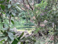
(S/E) At the footbridge, head up the Ravine Divon, following the path on the right bank. The walk begins beneath the orchards, which are home to trees – mainly mango trees – of enormous size. They are among the oldest on the island and are nearly 300 years old. These trees were planted by the island’s first inhabitants. The path sometimes runs alongside the cliff, where there are a few caves. The Ravine Divon is very close by and is just a simple stream. The banks are covered in songes and papyrus. Soon, a more open area offers a view upstream along the ravine. You’ll reach the first junction very quickly.

(1) Leave the path on the right and continue straight on. Occasionally, there are a few wooden benches and bins along the edge of the path. Some areas are suitable for a picnic. Then cross the ravine and turn immediately left, then left again at the next two junctions. Cross the ravine a second time to reach a climbing area.

(2) The Bassin Long is just beyond this climbing area. It takes its name from its length. The spot is suitable for a picnic. Birds nest in the hollows overlooking the pool. The pool itself has no waterfall. The path continues a short way past the pool but ends shortly afterwards at the ravine. Return to the previous junction, then keep to the left as you pass an old pipeline. Return to the car park (S/E).

Waypoints

  1. S/E : mi 0 - alt. 16 ft - Footbridge
  2. 1 : mi 0.22 - alt. 36 ft - Junction
  3. 2 : mi 0.46 - alt. 82 ft - Bassin Long - Bassin Long
  4. S/E : mi 1.08 - alt. 16 ft - Footbridge

Notes

This walk should be avoided in wet weather as it is at the bottom of a ravine.
You can have a picnic and go rock climbing at Bassin Long.
Benches and litter bins are available along the route.

Worth a visit

Reviews and comments

4 / 5
Based on 2 reviews

Reliability of the description
4.5 / 5
Ease of following the route
4.5 / 5
Route interest
3 / 5
Dr579
Dr579

Overall rating : 3.7 / 5

Date of your route : Oct 20, 2026
Reliability of the description : ★★★★☆ Good
Ease of following the route : ★★★★☆ Good
Route interest : ★★★☆☆ Average
Very busy route : No

Unfortunately, there was very little water when I went on this walk.
Nevertheless, it’s not particularly interesting.
I’d recommend doing it with the family, particularly if you have young children.

Machine-translated

danielfr40
danielfr40

Overall rating : 4.3 / 5

Date of your route : Feb 03, 2025
Reliability of the description : ★★★★★ Very good
Ease of following the route : ★★★★★ Very good
Route interest : ★★★☆☆ Average
Very busy route : No

An easy walk.
After the pond, the path becomes overgrown. I’d foolishly followed the track without realising I’d already reached the pond at point 2 – it was so long that I’d mistaken it for the river
Thank you for this route and the description

Machine-translated

Other walks in the area

For more walks, use our search engine .

The GPS track and description are the property of this route's author. Please do not copy them without permission.