Country:

 City:


From Bourg-Saint-Maurice, head towards Sainte-Foy-Tarentaise via the CD902. In the village, take the road towards Le Miroir and, at La Masure, turn right onto the small pastoral road leading up towards La Savonne. Park 300 m before this hamlet at the Pierre Giret car park, which is clearly signposted.
(S/E) From the car park, return to the road leading up towards La Savonne and, just after crossing the bridge at Savonne-aval, turn left onto the path that climbs towards the Louïe Blanche, heading for Lac du Retour.
(1) The path climbs along the left bank of the Louïe Blanche stream. Ignore the path on the right leading to the Refuge du Ruitor, then the one towards La Vacherie. At an altitude of around 1,900 metres, it crosses the stream and climbs up the right bank to a junction of paths at the altitude of 2,012.
(2) Ignore the main path straight ahead leading to the Passage de la Louïe Blanche and instead take a faint track to the left (heading west), which climbs straight up the slope on the right bank of a stream. This rugged path is uneven but marked with old red streaks and cairns. It takes you quickly up towards the Col du Retour, which you reach after joining, 200 metres before the pass, the path coming from the Louïe Blanche.
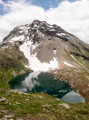
(3) After admiring the lake, return to the signposted path heading east and, at the first junction, turn left to take the Passage de la Louïe Blanche path, heading north-east then north.
It descends slightly, skirting around the rock slabs from the Pointe des Couloureuses, joins the path rising directly from below and, through pleasant terrain dotted with lakes, reaches the Passage de la Louïe Blanche, which has been clearly visible for some time.
(4) Head east along a cairn-marked track which starts off more or less level, passes close to lakes in an increasingly rocky landscape, then climbs gradually towards the border at a higher altitude (near the 2636-metre altitude) than the geographical Col de la Louïe Blanche.
(5) On the Italian side, the valley descending towards BellaComba comes into view: do not descend straight away but continue along the level ground, following the cairns, to discover two glacial lakes below Pointe Rousse.
(6) Go round the first lake to pass a small hill, from which the second lake comes into view. Then descend into the valley via an off-trail but easy route between the weathered rocks, either directly or by staying on the left-hand slope, which is grassier (GPS track). This leads to some old military barracks near the stream at the foot of the Col de la Louïe Blanche.
(7) Follow a cairn-marked track heading north-east along the valley; it is easy going at first, but you will eventually have to tackle the chaotic moraine – a more arduous descent – to reach the first Lac de Bella Comba, which you can see ahead.
The track leads into an alluvial plain extending upstream from the lake. The cairn-marked track, now a proper path, climbs to the right to pass a narrow pass and overlook the lake and its island.
(8) Continue to walk above the lake: the path can be followed all the way to its downstream end, but, before descending back down to lake level, a path branches off to the right which you must follow to climb up to the Col de Tachuy and cross back into France.
The path begins to climb and the view opens up nicely onto Mont Blanc and the other lakes, right up to the main one, Lac du Tachuy.
(9) Follow the left bank of the lake whilst staying at a higher elevation; the path then resumes its ascent through more rocky, undulating terrain and, after passing several smaller lakes, reaches the Col de Tachuy (or Col du Petit).
(10) Descend south-east along the steep path beside the Ruisseau du Petit to Lac du Petit, following its rugged right bank before reaching its far end.
(11) Take the path leading down alongside the outlet.
For a quick return, you can continue straight on to La Sassière and the Refuge du Ruitor, then reach La Savonne via the track suitable for vehicles.
However, it is also possible to include other lakes to visit (GPS track): 200 m after Lac du Petit, turn right onto faint off-trail tracks across grassy terrain, leading slightly uphill towards the plateaus stretching out beneath the Œillasses.
Continue as level as possible to cross a wide cirque alternating between grassy sections and chaotic moraines. There is no proper path, but there are occasionally tracks and even lines of cairns to guide your way.
Halfway through the level traverse, begin to climb gradually to reach the grassy ridge marked at 2,477 m on the IGN map. This brings you to a series of plateaus where small lakes lead down to Lac Verdet.
(12) Descend in a wide curve to the left to reach passable grassy slopes skirting Lac Longet. Continue downwards, leaving another lake on your right, until you reach a wet area from which a stream plunges down towards the valley. Here you’ll find cairns and a more distinct track coming from Lac Longet.
(13) Take this cairn-marked path to the right, which runs along the edge of the cliffs dropping down into the Petit valley. It remains at a steady altitude (around 2,350 m) for quite some time before reaching a grassy hummock near the point marked 2,353.
(14) The path finally begins to descend towards the valley, following a passable ridge, until it reaches a level section.
(15) The path continues straight ahead, but you must turn left to rejoin the south-facing slope heading towards the Sassière valley. Cut across several traverse paths, keeping a southerly direction, before finally climbing slightly along a good path to reach the hamlet of Les Mollettes and the Chapelle Saint-Pierre.
(16) Take the stony but dusty road which descends towards La Savonne and, at the second bend, take a path on the slope (to the north) which descends through the vegetation then veers westwards to join the Chemin de la Vacherie d’en Haut and leads back to the road.
Follow this flat road for about 400 metres.
(17) At the junction with the Chemin de la Vacherie d’en Bas, leave the road and take the path opposite which descends towards the stream and joins the Chemin de la Louïe Blanche taken earlier that morning.
(1) Continue down this path until you reach the tarmac road at La Savonne and the Pierre Giret car park (S/E).

 Visorando Member
 Difficult

 Association / Club / Walk leader
 Moderate
 Tourist office