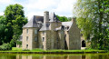
La Potelais through the Tronçon valley

The first little gem on this route is the Chapelle de la Potelais, tucked away in the heart of the countryside. Immediately afterwards, and for almost two kilometres, you are invited to follow the meandering course of the Tronçon through woods and fields.

Details

n°22746444
Creation:
Last update:
Last review:
  • Walking
    Activity: Walking
  • ↔
    Distance: 3.31 mi
  • ◔
    Average duration: 1h 35 
  • ▲
    Difficulty: Easy

  • ⚐
    Back to start: Yes
  • ↗
    Ascent: + 66 ft
  • ↘
    Descent: - 69 ft

  • ▲
    Highest point: 410 ft
  • ▼
    Lowest point: 315 ft
  • ⚐ Country: France
  • ⚐ City: Coglès (35460)
  • ⚑
    Start/End: N 48.459173° / W 1.363311°
  • ❏
    IGN map(s): Ref. 1316O
  • Hour-by-hour weather

Description of the walk

In Coglès, you can park opposite the town hall in the car park near the post office.

(S/E) Leave the car park with your back to the road and turn immediately right onto Rue du Vieux Chemin. At the end of this street, turn left onto Rue du Lavoir. You will soon see the wash house on your left. Head towards it, keeping it on your right, and continue along the path leading to a housing estate.

(1) At the entrance to the housing estate, turn right (Yellow Cross) and follow the street round its three 90° bends. Turn right almost immediately onto a path leading to the cemetery and go round it on the right-hand side.

(2) Take the path running alongside Rue du Chemin Vert and head east. Cross the road carefully using the steps and the designated crossing, then continue on the other side in the same direction until you reach the houses. Follow the road to the left towards La Noë. You will reach the D16.

(3) Cross carefully as always and carry on straight ahead towards the Chapelle de la Potelais. The path on the right leads there.

(4) At the chapel, carry on straight ahead, heading down towards Le Tronçon. Note the Marian grotto on the right. Take the hairpin bend to the left and then, after a few metres, follow the path on the right which runs alongside the river. The path leads to Pont Paquet.
Turn right and, immediately before the bridge, take the path on the left (warning sign for walkers).
All you have to do now is follow the meandering course of this capricious river.

(5) Cross a road and continue straight ahead, following the twists and turns of the path.

(6) When you reach the road at Bois Grignard, take note of the façade of the craftsman’s house (see below under ‘During the walk’). Follow the road to the left. Before the town entrance sign, head down the path on the right and pass between the two ponds. Continue to the left and rejoin the road.
Turn left to reach the village of Coglès via Rue du Roc and then Rue de Saint-Jean, continuing to the car park (S/E).

Waypoints

  1. S/E : mi 0 - alt. 367 ft - Post office car park
  2. 1 : mi 0.34 - alt. 361 ft - Entrance to the housing estate
  3. 2 : mi 0.63 - alt. 381 ft - Paved path
  4. 3 : mi 1.41 - alt. 404 ft - Departmental Road D16
  5. 4 : mi 1.65 - alt. 354 ft - Potelais Chapel. Head down towards the - Tronçon (rivière) - Affluent du Couesnon
  6. 5 : mi 2.16 - alt. 331 ft - Departmental Road D111
  7. 6 : mi 2.7 - alt. 315 ft - Le Bois Grignard
  8. S/E : mi 3.31 - alt. 367 ft - Post office car park

Worth a visit

The roofer’s house at Bois Grignard warrants two points of clarification:
- The word ‘DOUANE’ appears on the pediment: indeed, at this location, the Tronçon marks a departmental and regional boundary – between Ille-et-Vilaine and Manche, and thus between Brittany and Normandy.
- The word ‘essente’ is mentioned in the craftsman’s trade description. This refers to thin planks used for roofing, often made of chestnut (instead of tiles or slates).

Reviews and comments

3.3 / 5
Based on 3 reviews

Reliability of the description
3.3 / 5
Ease of following the route
3.7 / 5
Route interest
3 / 5
User 22239415

Overall rating : 3 / 5

Date of your route : Aug 11, 2025
Reliability of the description : ★★★☆☆ Average
Ease of following the route : ★★★☆☆ Average
Route interest : ★★★☆☆ Average
Very busy route : No

the paths are completely unmaintained. There are numerous passages through nettles. This spoils the enjoyment of the walk.

Machine-translated

VieilPat
VieilPat

Overall rating : 3 / 5

Date of your route : Aug 09, 2023
Reliability of the description : ★★★☆☆ Average
Ease of following the route : ★★★★☆ Good
Route interest : ★★☆☆☆ Disappointing
Very busy route : No

The washhouse and chapel sites are very pleasant, though the path leading to them is less so. The first part of the route involves a lot of road walking; when the road turns into a track as you approach the chapel, it is difficult to walk on for most of the way. Agricultural machinery has mown the ground and left very deep tracks from its knobbly tyres. This makes walking very difficult despite having good footwear (we’re wearing high-top walking boots).
It’s a shame, as a slightly levelled path would allow you to enjoy the walk along the stream and would make up for the tarmac at the start of the route.
The village of Coglès is full of flowers; the car park at the village hall is another parking option – it’s shaded, has picnic facilities and features dedicated parking spaces for motorhomes.

Machine-translated

OLVMALOU
OLVMALOU

Overall rating : 4 / 5

Date of your route : Jun 27, 2022
Reliability of the description : ★★★★☆ Good
Ease of following the route : ★★★★☆ Good
Route interest : ★★★★☆ Good
Very busy route : No

Places that are sometimes damp

Machine-translated

Other walks in the area

For more walks, use our search engine .

The GPS track and description are the property of this route's author. Please do not copy them without permission.