Country:

 City:
City:


To reach the start point from Bourg-Saint-Maurice, follow signs for Peisey-Nancroix then the Refuge de Rosuel.
Route described from the Lanchettes campsite; parking is also available at the point (1).
(S/E) From the campsite, head north-west and follow the D87 road downhill for approximately 250 m.
(1) Take the road leading uphill to the right, then turn left onto a track, cross the Ruisseau de Poncet and pass close to the Ferme de la Prairie (where cheese is sold).
(2) Leave the track and take a path that climbs to the right, overlooking the stream on its right bank. Then turn left to reach the hamlet of Pracompuet.
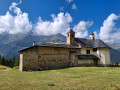
(3) Continue up a steep climb to the right, heading north towards the Chapelle des Vernettes.
(4) At the T-junction, turn right to reach a hairpin bend to the left. You’ll come out onto a track; follow it to the right at an acute angle. At the Fork in the road shortly afterwards, turn left and head for the chapel.
(5) Head back down due east, following the path that runs along the mountainside. Immediately on your right, ignore a path that descends steeply. Continue eastwards, climbing. Cross the Ruisseau de Poncet again.
(6) At the fork, follow a forest track to the left. You’ll come out onto another track at a hairpin bend; follow it to the left. Stay on this main track and ignore all side paths. This will take you to the Chalets des Rossets.
(7) Walk through the hamlet and head slightly uphill to join a path running along a ledge overlooking the Refuge de Rosuel. Keep heading south-east.
(8) Take the path that descends sharply to the right towards Beaupraz.
(9) Turn left onto the main track and ignore a path branching off to the right. Cross, in turn, a track, the hamlet of Beaupraz and a torrent.
(10) On the other side of the stream, follow a track to the right which runs parallel to the D87. After about 200 m, turn left and rejoin the road.
(11) Follow the D87 to the right and immediately take the first path on the left, following the GR®5 (red and white markings).
(12) Pass by the Palais de la Mine (information boards) and continue along the GR®, ignoring the paths branching off to the left.
(13) Turn right and cross the Lanchettes campsite. Cross the stream once more and you’ll immediately return to the starting point (S/E).
 Visorando Member

 Association / Club / Walk leader
 Difficult


 Easy
Easy