The Chapel of the Poor in Bayard-sur-Marne, starting from Bienville

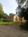
A walk to discover the Chapel of Our Lady of the Poor in Bayard-sur-Marne, built in 1954 by volunteers. Legend has it that a chapel had been built on the same site in the 17th century. A stone weighing 800 kg, which was discovered, serves as the altar in this chapel.

Details

n°71218965
Creation:
Last update:
Last review:
  • Walking
    Activity: Walking
  • ↔
    Distance: 6.04 mi
  • ◔
    Average duration: 3h 00 
  • ▲
    Difficulty: Easy

  • ⚐
    Back to start: Yes
  • ↗
    Ascent: + 276 ft
  • ↘
    Descent: - 269 ft

  • ▲
    Highest point: 719 ft
  • ▼
    Lowest point: 522 ft
  • ⚐ Country: France
  • ⚐ City: Eurville-Bienville (52410)
  • ⚑
    Start/End: N 48.571799° / E 5.045229°
  • Accessible from the train station Gare de Bayard.
  • ❏
    IGN map(s): Ref. 3016SB, 3116SB
  • Hour-by-hour weather

Description of the walk

Park in the car park behind Bienville Church.

(S/E) Leave the car park, take Rue de la Forge opposite, and follow this street to reach the canal footbridge. Cross the canal.

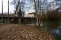
(1) Turn left immediately on the other side, at a right angle, and follow the towpath of the Canal between Champagne and Burgundy.

(2) Turn right onto Rue de la Gare, with Bayard-sur-Marne Town Hall on your left. Continue along this street until you reach the bridge over the Marne and cross the river.

(3) At the junction on the other side, turn right onto the D335. Further on, at the 166 mark, turn left to reach the chapel.

(4) Visit the chapel and its Stations of the Cross. To head back down to the village of Laneuville in Bayard, take a path to the left of the chapel which resembles a small ditch (thalweg). The descent is steep for 150 metres (it is possible to return to the D335 by following the reverse route of the ascent). Join the D335 again and turn right.

(3) At the junction, turn left onto Rue de la Gare (following the route in reverse to the outward journey).

(2) Continue along the road (Rue de la Gare), crossing the canal, with the Bayard Foundry on your right. Take the footbridge on the right to cross the watercourse (power station on your left).

(5) At the junction, turn left, then, 20 metres further on, turn right onto Chemin de Narcy.

(6) At the 194 mark, turn left onto a forest path and continue along this straight track.

(7) Carry on along the path, veering slightly to the left.

(8) At the junction by the water tower, turn left onto the D213. Take the first street on the right (Rue Robert Lemut).

(9) Turn left 100 metres further on to reach the car park (S/E).

Waypoints

  1. S/E : mi 0 - alt. 531 ft - Car park behind the - Église Sainte-Menehould (Bienville)
  2. 1 : mi 0.22 - alt. 531 ft - Crossroads - Canal entre Champagne et Bourgogne
  3. 2 : mi 2.13 - alt. 545 ft - D184 road.
  4. 3 : mi 2.4 - alt. 541 ft - Junction - Marne (la)
  5. 4 : mi 2.97 - alt. 676 ft - Chapel of Our Lady of the Poor
  6. 5 : mi 3.72 - alt. 545 ft - D8 junction
  7. 6 : mi 3.93 - alt. 633 ft - Path on the left
  8. 7 : mi 4.76 - alt. 712 ft - Left-hand bend
  9. 8 : mi 5.56 - alt. 643 ft - Junction
  10. 9 : mi 5.85 - alt. 564 ft - Turn left
  11. S/E : mi 6.04 - alt. 531 ft - Car park behind the church

Worth a visit

Reviews and comments

5 / 5
Based on 1 review

Reliability of the description
5 / 5
Ease of following the route
5 / 5
Route interest
5 / 5
Noisette52
Noisette52

Thank you very much for your comments. Enjoy your hikes with your hiking group.

Machine-translated

Gilles MSD
Gilles MSD

Overall rating : 5 / 5

Date of your route : Feb 08, 2026
Reliability of the description : ★★★★★ Very good
Ease of following the route : ★★★★★ Very good
Route interest : ★★★★★ Very good
Very busy route : Yes

A very pleasant route, first along the canal, then discovering the well-maintained site of "La chapelle de Notre Dame des pauvres" (Our Lady of the Poor Chapel), which is definitely worth a visit. The route ends with a very enjoyable stroll through the forest along beautiful, clean paths that are easy to follow.
I did this last week with a group of 25 hikers.
I highly recommend it.

Machine-translated

Other walks in the area

For more walks, use our search engine .

The GPS track and description are the property of this route's author. Please do not copy them without permission.