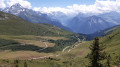
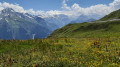
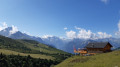
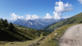
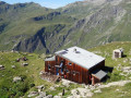
The Bozelet Chapel as seen from the Champagny cable car

A lovely walk in very open countryside, with no major difficulties.
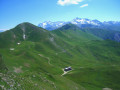
We did it at the end of July and it felt like we were in a flower garden.

Details

11923495
Creation:
Last update:
Last review:
  • Walking
    Activity: Walking
  • ↔
    Distance: 7.53 mi
  • ◔
    Average duration: 4h 30 
  • ▲
    Difficulty: Moderate

  • ⚐
    Back to start: Yes
  • ↗
    Ascent: + 1,152 ft
  • ↘
    Descent: - 1,135 ft

  • ▲
    Highest point: 7,454 ft
  • ▼
    Lowest point: 6,434 ft

Photos

Description of the walk

(S/E) From the top station of the Champagny cable car, head towards the Chalet du Bozelet (this chalet has been renamed the Chalet des Verdons Sud).

(1) At the fork in the road near the start of the Éterlou ski lift, turn left. Pass under a ski lift cable and then a chairlift cable, and follow the path heading due north. After a left-hand bend, head south again and you’ll come to a hairpin bend.

(2) Leave the main path and follow the path on the left which passes in front of the Chalet des Verdons Sud, towards Mont de la Guerre / Chapelle de Bozelet. Pass under the chairlift line of the same name. Follow the pleasant, south-west-facing balcony path until you reach the Y-junction.

(3) Take the path climbing to the right towards the Chapelle du Bozelet. Climb, initially heading north. You’ll reach a T-junction with the track.

(4) Turn left towards the Chapelle de Bozelet.

(5) At the next junction, veer left, immediately ignoring a path branching off to the left, and you’ll soon reach the Chapelle de Bozelet (a viewpoint and a good spot for a break).

(6) Retrace your steps back to the previous junction.

(5) Turn right (east) onto the track to reach the T-junction you passed earlier.

(4) Continue straight on and stay on the track heading towards the Col de la Grande Forcle. Pass under the Verdons Sud chairlift line and stay on the track. You’ll reach a crossroads before the pass (elevation 2189).

(7) Turn right here and, at the junction immediately ahead, turn right again. Descend without leaving the track, heading towards the Chalet des Verdons Sud. You’ll come to the hairpin bend near the Chalet des Verdons Sud.

(2) Turn left, staying on the track, and follow the same route as on the way there to return to the cable car station (S/E).

Waypoints

  1. S/E : mi 0 - alt. 6,434 ft - Upper station of the - Télécabine de Champagny
  2. 1 : mi 0.08 - alt. 6,476 ft - Fork in the road
  3. 2 : mi 1.21 - alt. 6,529 ft - Hairpin bend
  4. 3 : mi 2.36 - alt. 6,811 ft - Y-junction
  5. 4 : mi 3.1 - alt. 7,326 ft - T-junction
  6. 5 : mi 3.25 - alt. 7,415 ft - Junction
  7. 6 : mi 3.34 - alt. 7,454 ft - Chapelle de Bozelet (Bozel)
  8. 7 : mi 5.37 - alt. 7,178 ft - Crossroads
  9. S/E : mi 7.53 - alt. 6,434 ft - Upper station of the - Télécabine de Champagny

Notes

Wear sturdy shoes, even though the route is easy.
The cable car: €7 per person in summer 2021, with a free return journey for everyone.

Worth a visit

The Chalet des Verdons Sud (formerly the Chalet de Bozelet) is a very pleasant place; it’s lovely both inside and out… and the welcome is extremely warm.

Reviews and comments

4.3 / 5
Based on 3 reviews

Reliability of the description
4.3 / 5
Ease of following the route
4.3 / 5
Route interest
4.3 / 5
ducastelcb
ducastelcb

Overall rating : 5 / 5

Date of your route : Jul 22, 2025
Reliability of the description : ★★★★★ Very good
Ease of following the route : ★★★★★ Very good
Route interest : ★★★★★ Very good
Very busy route : No

A pleasant surprise upon arriving at the top of the cable car. A very nice hike with beautiful views. We went in July, and there weren't many people.
At point 7, we took the trail that goes to the Col de la Grande Forcle. Beautiful view.
Be careful, there isn't much shade.

Machine-translated

riri13
riri13

Overall rating : 3.3 / 5

Date of your route : Sep 02, 2024
Reliability of the description : ★★★☆☆ Average
Ease of following the route : ★★★★☆ Good
Route interest : ★★★☆☆ Average
Very busy route : No

Hello.
A nice route, not very difficult. The return leg along the track is a bit less interesting.
On the way back, a climb and descent over the pass offers views of La Plagne resort.
We didn’t come across many people: just a few walkers and two or three trekkers.
Picked some blueberries near the top of the cable car.
Please note: dogs aren’t allowed on the cable car, which makes the hike quite a bit longer.

Machine-translated

valejale
valejale

Overall rating : 4.7 / 5

Date of your route : Jul 17, 2023
Reliability of the description : ★★★★★ Very good
Ease of following the route : ★★★★☆ Good
Route interest : ★★★★★ Very good
Very busy route : No

At point 3, I’d recommend continuing straight on towards the picnic table; there’s a lovely view of Courchevel and its Olympic ski-jumping stadium from there.
Then there’s a second picnic table… followed by the Mont de la Guerre route towards the Bozel Chapel (watch out for marmots on this path).

Machine-translated

Other walks in the area

For more walks, use our search engine .

The GPS track and description are the property of this route's author. Please do not copy them without permission.