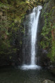
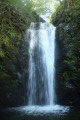
The Putzubeltz waterfall in Arantza

There are numerous waterfalls around the village of Arantza, though some are difficult to reach. The most famous and easiest to access is the Putzubeltz waterfall. The Arantza local council has also created a lovely, fairly easy path leading to it. You start by walking across meadows, then quickly find yourself in the middle of the forest, with the only sound being the trickling of small streams.

Details

41096673
Creation:
Last update:
Last review:
  • Walking
    Activity: Walking
  • ↔
    Distance: 6.70 mi
  • ◔
    Average duration: 4h 15 
  • ▲
    Difficulty: Moderate

  • ⚐
    Back to start: Yes
  • ↗
    Ascent: + 1,385 ft
  • ↘
    Descent: - 1,355 ft

  • ▲
    Highest point: 1,348 ft
  • ▼
    Lowest point: 837 ft

Photos

Description of the walk

The starting point of the walk is at the car park, at the entrance to the village of Arantza (or Aranaz in Basque), on Rue Beheko. To get there, see the ‘Practical Information’ section.
The walk is signposted, either by signs or by blue and white markings. The suggested route is almost entirely a return walk, except for a short section where you can take an alternative route.

(S/E) From the car park, head towards the village along Rue Beheko. Walk past the school, where you’ll find the first signpost; follow the direction for “otras rutas” (other routes). You’ll then pass the town hall. The street bends left and then right. Carry on to the right, where you’ll come to a second sign (Putzubeltza 5.5 km), and take the next street leading down to the left (there’s a sign for Aterpe), Rue Osina. Continue along this street without turning right or left. You’ll reach a junction where two streets are separated by a low wall. Follow the left-hand street (towards Aterpe) and, immediately, take the small stony path on the left, at a third signpost. Look out for the white and blue markings and follow them.

(1) Turn right, following the markings.

(2) You’ll come to a concrete track. Turn left, then, shortly afterwards, turn right in front of house no. 13301. You’ll reach a junction with a sign indicating that your destination is 3.5 km away. Turn right and head down a concrete road.

(4) At a fairly large hole on the left-hand side of the road, leave the road and continue straight on along the dirt track, following the white and blue markings. In the middle of the forest, pass a lovely fountain. You’ll come to another sign indicating that your destination is 2.5 km away.

(5) Carry on straight ahead. 100 m further on, look out for a wooden sign by the side of the road marked ‘Putzu beltz’. Leave the main road and take the small path on the left. This leads onto a concrete track

(6) Follow it to the right.

(7) At the junction, take the path on the right. Shortly afterwards, at the crossroads, go straight on. You’ll arrive at the farm known as “Beraskun”.

(8) Turn left and head for the Putzubeltz waterfall.

(9) Return along the same path in the opposite direction.

(6) Suggested alternative route for the return journey, following this route: continue straight on along the track. Admire a few bordas and, in particular, note the very large house-shaped letterbox on one of them – a common sight in the region. About 800 metres further on, head down to the left for a few dozen metres to rejoin the path taken on the way out.

(3) Opposite, follow the outbound route in the opposite direction.

(2) On the zigzag section, don’t forget to take the small path on the right at the letterbox.
Continue on to return to the village of Arantza and then to the car park (S/E).

Waypoints

  1. S/E : mi 0 - alt. 846 ft - Car park on Rue Beheko
  2. 1 : mi 0.59 - alt. 919 ft - Junction
  3. 2 : mi 1.02 - alt. 1,145 ft - Zig-zag
  4. 3 : mi 1.27 - alt. 1,234 ft - Sign
  5. 4 : mi 1.46 - alt. 1,093 ft - Hole
  6. 5 : mi 1.77 - alt. 1,214 ft - Sign
  7. 6 : mi 2.02 - alt. 1,273 ft - Track
  8. 7 : mi 2.24 - alt. 1,293 ft - Junction
  9. 8 : mi 3.03 - alt. 837 ft - Farm
  10. 9 : mi 3.4 - alt. 948 ft - Cascade de Putzubeltz
  11. S/E : mi 6.7 - alt. 850 ft - Car park on Rue Beheko

Notes

To get to the starting point by car

From Saint-Jean-de-Luz, head to Béhobie to cross the border.
After crossing the bridge, turn left at the roundabout onto the N121A towards Pamplona.
On the N121A, at kilometre 58, take the NA-4020 exit for Igantzi / Arantza.
At the roundabout, take the second exit onto the NA-4020 towards Igantzi / Arantza. Follow the NA-4020.
At the roundabout, take the second exit towards the NA-4020 Arantza (so do not take the right-hand exit for the NA-4052 Igantzi).
Carry on along the NA-4020 for quite a while (you’ll pass the Yanci and San Juan Xar quarries).
You’ll enter Arantza, pass a few blocks of flats, and the car park is immediately on the right-hand side of the road, opposite a large bus park: you’re on Rue Beheko (Beheko Karrika).

For your information: by car from Saint-Jean-de-Luz, the journey is 35 km and takes around 50 minutes.

Worth a visit

Visit the village of Arantza.

Reviews and comments

4.8 / 5
Based on 3 reviews

Reliability of the description
5 / 5
Ease of following the route
5 / 5
Route interest
4.3 / 5
Mapie.e
Mapie.e

Overall rating : 4.7 / 5

Date of your route : Jul 24, 2026
Reliability of the description : ★★★★★ Very good
Ease of following the route : ★★★★★ Very good
Route interest : ★★★★☆ Good
Very busy route : No

A walk along clean, clear and well-signposted paths, mostly in the shade, leading to the Putzubeltz waterfall – a refreshing haven on these hot summer days. It’s a bit of a physical challenge, as you’ll cover around 12 kilometres, with a mix of ascents and descents throughout the route, though there are no difficult sections. Walking through the pretty village of Arantza is a lovely and enjoyable experience.

Machine-translated

eric bourdon
eric bourdon

Overall rating : 5 / 5

Date of your route : Aug 15, 2024
Reliability of the description : ★★★★★ Very good
Ease of following the route : ★★★★★ Very good
Route interest : ★★★★★ Very good
Very busy route : No

We did this walk on 15 August, Arantza’s feast day. Everyone was in the village and there were very few people at the waterfall. Normally there must be far more walkers, as the spot is stunning and the walk is relatively easy. It’s well signposted and easy to get to; the only slight difficulty is the series of fairly steep ascents and descents, but nothing too challenging.

Machine-translated

Lannemi
Lannemi

Overall rating : 4.7 / 5

Date of your route : Jan 12, 2024
Reliability of the description : ★★★★★ Very good
Ease of following the route : ★★★★★ Very good
Route interest : ★★★★☆ Good
Very busy route : No

A lovely walk that can be enjoyed in any season, with wooded sections and other points of interest. The route takes you through a valley from which you can see the surrounding peaks (which were snow-capped on the day of our walk). The paths are pleasant to walk along. Although the return leg of the ‘route’ follows a tarmac road, it offers some lovely views. Towards the end of the walk, we’re accompanied by the sound of the streams and torrents that we follow and cross. There’s a beautiful waterfall at the end of the walk, where in summer it must be possible to cool off in the pool at the base of the falls.
This walk is well signposted, straightforward and suitable for families.
The three bars and inns at the end of the route are a bonus.

Machine-translated

Other walks in the area

For more walks, use our search engine .

The GPS track and description are the property of this route's author. Please do not copy them without permission.