Grand Tour of Iwuy

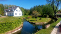
This walk takes you round the town and the municipal park (a former seigneurial estate) with its pond.

Details

39710313
Creation:
Last update:
Last review:
  • Walking
    Activity: Walking
  • ↔
    Distance: 5.31 mi
  • ◔
    Average duration: 2h 30 
  • ▲
    Difficulty: Easy

  • ⚐
    Back to start: Yes
  • ↗
    Ascent: + 79 ft
  • ↘
    Descent: - 79 ft

  • ▲
    Highest point: 203 ft
  • ▼
    Lowest point: 121 ft
  • ⚐ Country: France
  • ⚐ City: Iwuy (59141)
  • ⚑
    Start/End: N 50.238826° / E 3.313242°
  • ❏
    IGN map(s): Ref. 2606O
  • Hour-by-hour weather

Description of the walk

Parking is available in front of the Parc Communal at the end of Rue de La Tour: watch out for speed bumps.

(S/E) With your back to the pond, head left and head south-east until you reach a junction.

(1) Turn left onto Rue Pasteur. Cross Rue du 19 mars 1962 and continue straight ahead until you reach the main road (Rue Joffre).

(2) Cross it carefully and continue straight ahead along Rue de Lieu Saint-Amand until you reach the first turn-off on the right.

(3) Take this and carry on straight ahead until you reach the junction near the bridge over the railway line, then continue straight on to the entrance to the cemetery.

(4) Enter the cemetery, walk across it on the right-hand side following the path, and exit. Turn right, then take the sharp left onto Rue Marie Larivière without going all the way to the railway line.

(5) Before reaching the level crossing, turn right onto Rue du 8 mai 1945 until you reach a former SNCF shed, visible on the left through the vegetation.

(6) Turn onto a path on the right, cross Rue des Martyrs and continue straight ahead until you reach Rue du Pont d’Iwuy (D630).

(7) Cross it carefully at the pedestrian crossing, turn left onto the pavement on the right and cross the Erclin. Carry on until you reach the second path on the right, about 40 metres further on.

(8) Take this path and walk along the bottom of the embankment of a settling basin. Continue to the end of the path.

(9) Turn left, then immediately right onto a tarmac-surfaced road. At the end of this road, turn right onto Rue de Cutiviers. Take care – there is some traffic. You will come to a fork in the road.

(10) Turn right at the junction. Cross the first bridge over the Erclin, then a second one after walking along the embankment of a settling basin at a lower level. Continue along Rue Danton until you reach the original junction.

(1) Turn left and head for the car park.

(S/E) Continue round the pond, either clockwise or anti-clockwise, and return to the starting point (S/E).

Waypoints

  1. S/E : mi 0 - alt. 125 ft - Communal park car park.
  2. 1 : mi 0.26 - alt. 141 ft - Junction of the circular loop
  3. 2 : mi 0.5 - alt. 157 ft - Rue Joffre
  4. 3 : mi 0.66 - alt. 161 ft - Path on the right
  5. 4 : mi 1.34 - alt. 187 ft - Cemetery
  6. 5 : mi 1.76 - alt. 171 ft - Rue du 8 mai 1945
  7. 6 : mi 2.04 - alt. 161 ft - Former SNCF depot on the left
  8. 7 : mi 2.66 - alt. 135 ft - Rue du Pont d’Iwuy
  9. 8 : mi 2.81 - alt. 138 ft - Erclin (river) – A tributary of the Scheldt
  10. 9 : mi 3.24 - alt. 125 ft - Junction, left/right
  11. 10 : mi 3.97 - alt. 128 ft - Junction, turn right
  12. S/E : mi 5.31 - alt. 125 ft - Communal park car park

Notes

(4) If the cemetery is closed, continue along Rue du 4 Septembre, then turn left onto Rue de l’Égalité to reach Rue Marie Larivière, which will then be on your right.

Reviews and comments

4.3 / 5
Based on 2 reviews

Reliability of the description
4.5 / 5
Ease of following the route
4.5 / 5
Route interest
4 / 5
Jacky dum
Jacky dum

Overall rating : 4.7 / 5

Date of your route : Dec 27, 2023
Reliability of the description : ★★★★☆ Good
Ease of following the route : ★★★★★ Very good
Route interest : ★★★★★ Very good
Very busy route : No

A lovely route

Machine-translated

randodom(
randodom(

Overall rating : 4 / 5

Date of your route : Dec 21, 2023
Reliability of the description : ★★★★★ Very good
Ease of following the route : ★★★★☆ Good
Route interest : ★★★☆☆ Average
Very busy route : No

A village of moderate interest, followed by a more (green) route. We passed close to the Pré des Bosquets without crossing it (ponds), then followed the departmental road for a long stretch, leading us to take a pleasant path on the left which crossed the THuN St Martin route.

Machine-translated

Other walks in the area

For more walks, use our search engine .

The GPS track and description are the property of this route's author. Please do not copy them without permission.