Country:

 City:
City:


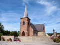
Start from the Ferrière-la-Grande Eco-Cycle Relay accommodation.
(S) Head towards the roundabout, take the3rd exit on the right onto Rue Jean Jaurès, then the2nd on the right onto Rue des Écoles.
In front of the church, turn right and then left onto Rue Casimir Fournier
Go straight on and continue along Rue Alphonse Splingard (D295). You’ll reach the junction with theGR®®655.
Red and white markings forthe GR®®655
(1) Turn left onto a dirt track which leads to the D95 at the junction by a gas installation.
(2) Continue left until you reach the sign marking the entrance to the village of Ferrière-la-Grande. Take thefirst gravel track on the right – this is the Chemin du Bourdiau.
(3) At the next fork, turn left towards the hamlet of Champ de Loup. Take the road on the right. Pass through the hamlet of Marlière. After a right-hand bend, leave the Chemin de Ropsies on your left and carry on.
(4) Enter Beaufort on the left via Rue Georges Clemenceau. Cross the Grande-Rue (D155), then continue straight ahead along a grassy track which becomes a narrow lane and leads out onto Rue Victor-Hugo.
(5) Follow Rue Victor Hugo for a few metres to the right and take thefirst left. You’ll reach Rue Pasteur.
(6) Turn right for a few metres, then left into Ruelle de la Briquette. Take a path on the left leading into Ruelle Tournante, which you should follow to the left. Walk past the church and Beaufort Town Hall on Rue Aristide Briand.
(7) Between the houses, turn right onto a grassy path on Rue Joyeuse. At the end of the path, first turn right then left and take a tarmac road, Chemin d’Avesnes. Continue to a junction on the edge of Bois le Roi.
Junction with the GRP® Tour de l’Avesnois, Fagnes and Val Joly circular loop.
Junction with the GRP® Tour de l’Avesnois, Bocages and Maroilles circular loop.
(8) Turn right onto a grassy path, cross the N 2 with care and continue straight ahead along Chemin de la Belle Hôtesse. Ignore a path on the left; at the T-junction, turn left onto the D307 and cross a bridge.
Leave the St James’s Way to reach the accommodation ‘La Maison d’Eclaibes’. To do this, turn left onto Rue de l’Abreuvoir, then right onto Chemin Margot; at the four-way junction, go straight ahead and you will find accommodation no. 10 100 metres ahead on the right (E).

 AONB
AONB
 Easy
Easy 
 Visorando Member