Country:

 City:
City:


Coming from Hellert via the D98d, enter the village of La Hoube via Rue de Belle Vue and, approximately 200 metres after the village sign, take the turn-off to the right between the green barriers to park on the grassy area leading to the Kuhberg Forest Road.
(S/E) From the car park, walk up Rue de Belle Vue in the opposite direction to the one you arrived in by car, leave the village and turn right after the large glass recycling bins onto the unmarked Kuhbergkopf Forest Road for a few metres.
Red Triangle signposting, Route to the Kuhbergkopf Rock
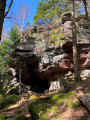
(1) Turn right, heading north, onto the path climbing through the woodland signposted ‘Rocher du Kuhberg – MF Kempel’. Pass a rocky outcrop on your left (the summit is accessible via a path at the northern end) then reach the Fork in the road on the two Red Triangle paths. Do not take the path on the right marked “modified route” to reach the viewpoint.
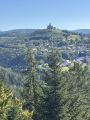
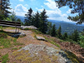
(2) Continue along the left-hand path; after about 200 m, on the left, you’ll reach the Rocher du Kuhbergkopf, signposted “Viewpoint 2 min”, with a stunning view of the Rocher de Dabo and the surrounding area, and a bench. Retrace your steps, take the path on the left for about thirty metres, then turn right to rejoin the Red Triangle markings.
(3) Continue along the path which, after about 250 m, joins the “modified route” before beginning the descent. This descent, with its tight hairpin bends, crosses two forest tracks before reaching the road and the Kempel Forest House.
Blue Triangle markings, Trois Rochers circular loop: Pfannenfels, Kelchfels, Marguerite
(4) (On the right, there is the option to extend the route by 1.5 km return, as described in the “Places to See” section.) Turn left towards “Pfannenfels Kelchfels” and, after a few metres, turn right onto the path that joins the Kempel Forest Track at Hulthouse. Continue to the right along this track for about a hundred metres, then turn right again, following the ‘Pfannenfels’ signposting. Walk past the Kempel Forest House (bench). Continue until you reach the junction where the two paths meet (Fork in the road).
(5) Take the left-hand path. Continue northwards; when the path veers to the left, after a few dozen metres you’ll reach the start of a path on the far left.
(6) Take this path uphill towards the promontory, following the “Pfannenfels” signposts. Walk the short circular path, which offers lovely views of the Dabo rock and the surrounding area, as well as a mushroom-shaped rock, then return to the junction. Continue to the left, following the “Kelchfels Margarethenfels” signposts for about 60 metres.
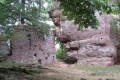
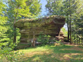
(7) Turn right onto a narrow path, following the “Kelchfels 5 min” signpost. Walk to the beautiful chalice-shaped Kelchfels rock and retrace your steps. Continue to the right, still heading towards the Margarethenfels path and rock, until you reach the junction with the stony forest track signposted “Margarethenfels 2 min”.
Margarethenfels signpost
(8) Turn right and head down the Margaretenweg path. After about a hundred metres, at the left-hand bend, turn left towards Margarethenfels and then retrace your steps. Continue down the forest path until you reach the hairpin bend.
(9) Head right onto the grassy forest track. Continue due south until you reach the Fork in the road you passed earlier.
Blue Triangle markings.
(5) Head down the path, in the opposite direction to the outward journey, passing behind the Kempel Forest House to join the Kempel Forest Track at Hulthouse. Continue to the left, leaving the outward route on your right, and carry on straight ahead to join the Kempel Forest Road. Turn sharply left for about 40 metres to join the forest path on the right signposted ‘Borne St-Martin’.
Pierre St Martin (Martinstein) Route, Markings: Red Rectangle with a White Bar
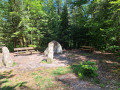
(10) Head up the path, then stay on the path on the right to reach a small clearing at a place called Martinstein (St Martin’s Stone – two boundary stones and an old menhir boundary stone, picnic area).
Marked with a Yellow Rectangle (GR®532)
(11) Take the path marked with a Yellow Rectangle (GR®532) to reach the Kempel Forest Road and its large car park. Cross the road, veering to the left, and rejoin the GR®532.
(12) Continue along the forest track running alongside the D98d to reach and cross the Nusskopf Forest Road; carry on straight ahead on the GR®532, where the GR® markings are supplemented by a Red Ring (the Rocher du Nusskopf circular route).
Nusskopf Circular Loop
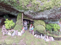
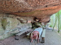
(13) The path runs the entire length of the Nusskopf rocky ridge and provides access, on the right, to a narrow path leading to the Grotte du Marcel, a large cave fitted out as a picnic spot. Retrace your steps to continue along the ascending bend and turn right.
Red Ring markings
(14) Leave the GR®532 on your left and continue along the summit section of the Rocher du Nusskopf. Pass the ‘Arbre à la Vierge’ and reach the spot known as Rocher du Nusskopf , with its stunning view of the Rocher de Dabo and the surrounding area (bench).
(15) Retrace your steps for about ten metres and take the path leading down to the right, round the back of the rock, to join the Route Forestière du Nusskopf and the GR®532.
Markings: Yellow Rectangle GR®532, Return to the village of La Hoube
(13) Head left, in the opposite direction to your outward journey, and make your way back towards the Kempel Forest Road.
(12) Cross it diagonally to the right to join the path running about twenty metres behind the forest sign ‘Route forestière du Kempel’. Continue to the left, then immediately to the right, until you reach a multi-way junction.
(16) Leave the first forest track, which joins the D98d, on your right and take the second one to continue straight on across flat ground along the forest track that runs alongside the D98d. This track joins the unmarked forest track situated just above it. Continue to the right and return to the junction you encountered at the start.
(1) Join the D98d, enter the village of La Hoube and return to the car park (S/E).


 Visorando Member

 Easy
Easy