From Haréville to La Neuveville

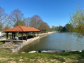
A pleasant, relatively easy circular walk, with a shaded section on the climb up to Maximois and a stretch passing by the Étang de la Neuveville.

Details

2456634
Creation:
Last update:
Last review:
  • Walking
    Activity: Walking
  • ↔
    Distance: 5.66 mi
  • ◔
    Average duration: 3h 05 
  • ▲
    Difficulty: Easy

  • ⚐
    Back to start: Yes
  • ↗
    Ascent: + 505 ft
  • ↘
    Descent: - 505 ft

  • ▲
    Highest point: 1,532 ft
  • ▼
    Lowest point: 1,135 ft
  • ⚐ Country: France
  • ⚐ City: Haréville (88800)
  • ⚑
    Start/End: N 48.206261° / E 5.998944°
  • Accessible from the train station Gare de Hareville/Montfort Ctre.
  • ❏
    IGN map(s): Ref. 3318SB
  • Hour-by-hour weather

Description of the walk

Parking is available at the Haréville town hall car park.

(S/E) From the car park, walk past the school and, at the bottom of the street, turn right onto Rue de la Gare and follow it to the end. Turn right at the fork and continue straight on towards the La Voque housing estate.

(1) At the end of the road, turn left, cross the railway bridge and head uphill to the Ferme de Maximois.

(2) Carry on straight ahead, passing under the power line.

(3) Turn right onto the gravel track beneath the power line. Continue along the track, which offers a lovely view at the end.

(4) Turn right, go down the slope and then follow the path that runs alongside the pastures.

(5) Just before a stream, turn right onto a path and continue alongside the stream.

(6) At the crossroads, turn right onto the street running parallel to Rue de la Cornée.

(7) Turn right at thefirst street you come to.

(8) Turn right again onto a wide path.

(9) At the 90° left-hand bend, carry straight on along the path which enters the Bois de la Charme. A gentle climb leads onto the Chemin de Maximois.

(2) Head down to the left towards Haréville, following the path in the opposite direction to the way out, to reach the car park (S/E).


Waypoints

  1. S/E : mi 0 - alt. 1,240 ft - Town hall car park
  2. 1 : mi 0.56 - alt. 1,260 ft - Bridge over the railway line
  3. 2 : mi 1.21 - alt. 1,365 ft - Junction for both out-and-back routes
  4. 3 : mi 1.42 - alt. 1,506 ft - Viewpoint
  5. 4 : mi 2.26 - alt. 1,496 ft - Junction on the right
  6. 5 : mi 3.15 - alt. 1,175 ft - Junction on the right
  7. 6 : mi 3.37 - alt. 1,145 ft - Junction; take the road on the right. Cross the - Saule (cours d'eau) - Afluent du Madon
  8. 7 : mi 3.49 - alt. 1,135 ft - Street on the right
  9. 8 : mi 3.55 - alt. 1,138 ft - Wide path on the right
  10. 9 : mi 4.17 - alt. 1,240 ft - Entrance to the woods
  11. S/E : mi 5.66 - alt. 1,240 ft - Town hall car park

Worth a visit

Beautiful view from the top of Maximois.

Reviews and comments

3.9 / 5
Based on 4 reviews

Reliability of the description
4.3 / 5
Ease of following the route
4.3 / 5
Route interest
3.3 / 5
RandoLuc
RandoLuc

Overall rating : 4.3 / 5

Date of your route : Aug 13, 2023
Reliability of the description : ★★★★★ Very good
Ease of following the route : ★★★★★ Very good
Route interest : ★★★☆☆ Average
Very busy route : No

Beautiful scenery, lots of tarmac, but you can take the forest paths after the railway bridge – take the first path on the left, then left again, and finally right; this way you avoid the road!

Machine-translated

franchie
franchie

Overall rating : 3.7 / 5

Date of your route : Aug 11, 2022
Reliability of the description : ★★★★☆ Good
Ease of following the route : ★★★★☆ Good
Route interest : ★★★☆☆ Average
Very busy route : No

The circular route could just as easily start from the Maximois Day Centre (point 2), as crossing the Haréville housing estate and the section along the tarmac road are of little interest.

Machine-translated

BY
BY

Overall rating : 4.7 / 5

Date of your route : Jul 10, 2020
Reliability of the description : ★★★★★ Very good
Ease of following the route : ★★★★★ Very good
Route interest : ★★★★☆ Good
Very busy route : No

A lovely walk, mainly through the forest. We really enjoyed the return leg from point 4. We found a path through the Bois de la Vague, running roughly parallel to the railway line – a pleasant alternative to the rather uninteresting path on the other side of the railway, between points 1 and DA, which runs alongside a housing estate. Another section that could do with some improvement is the stretch between points 3 and 4, which isn’t very pleasant as it runs alongside the high-voltage power line. Would it be possible to go through the woods instead? There might not be a path there, though…
Thank you and best regards,
Yves.

Machine-translated

jpm88800
jpm88800

Overall rating : 3 / 5

Date of your route : Oct 02, 2019
Reliability of the description : ★★★☆☆ Average
Ease of following the route : ★★★☆☆ Average
Route interest : ★★★☆☆ Average

Inaccuracies on the route map, points 5, 6, 7 and 8. Which stream? Never seen it; the wash house is quite a long way off, down below, and then at the crossroads, right or left??? Be careful, as there are hiking signposts (yellow lines) and/or red and white ones, right in front of us, and yet they don’t lead anywhere near where you’re supposed to go!!! But anyway; apart from that, there’s not much to see – let’s not kid ourselves – and plenty of roads or farm tracks. I’d expected to be deeper in the woods on some nice little paths. A short fitness walk to do on a Sunday morning, taking about 1 hour 45 minutes at a leisurely pace.

Machine-translated

Other walks in the area

For more walks, use our search engine .

The GPS track and description are the property of this route's author. Please do not copy them without permission.