Country:
 City:


The route starts at Orry-la-Ville/Coye station.
(S) From the station, head towards the D118 and the railway bridge. At the bridge, take the track running alongside the railway line. At the first junction, turn right onto another track heading north-east. Continue straight on until you reach the Poteau des Grandes Ventes.
(1) Turn left onto the first road (Route du Champoleux). Carry on straight ahead at the first three junctions, then at the fourth (Carrefour Saint-Ladre), take the second path on the right. Stay on the same track until you reach the signpost at the Carrefour de Viarmes. At this point, go round the signpost on the right and take the path that leads downwards, starting just before a forest track.
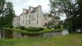
(2) Stay on the same path until you reach the Étang de la Loge and the Château de la Reine Blanche. When you reach the château, carry straight on along the path skirting the edge of the pond. At the bend, turn right, then take the first path on the right which continues to run alongside the pond. Keep going straight on at every junction with paths leading to the pond dams, until you reach the fourth path.
(3) At this point, turn left. Then turn right at the bend. Carry straight on at the first junction. You will then reach the D924A at Mongrésin.
(4) Carry on almost straight ahead along a track that initially passes some houses. Keep to the right straight away, then, at the next two junctions, turn left onto the Chemin de Mongrésin. Carry on straight ahead at the next junctions. At the sixth, turn right onto the Route du Ministre.
(5) Carry on straight ahead at the next junction, situated near an abandoned house. At the end of the track, turn left onto the second road (Route des Tilleuls) then turn onto the first track on the right. Stay on the same track until it ends at Pontarmé Castle.
(6) Turn left at the château onto its access road, then head left onto the D1017.
(7) At a wayside cross, turn right onto a track. Then turn right again to stay on the Chemin de la Layette.
Continue straight on at every junction until you reach the Red Cross (the next cross), located in the village of Thiers-sur-Thève.
(8) At the crossroads by the cross, turn left onto the track closest to the houses. Carry on straight ahead at the next six crossroads.
(9) At the seventh junction, turn right, heading almost due east, onto the Route Vieille. You will then reach a sandy, open area. A GPS may be useful in this area.
Cross this area and climb to the summit of the Butte aux Gens d’Armes, following the GR® as closely as possible.
(10) Once at the top of the hill, follow it to the right. Then head back down to the Route Vieille via the south-eastern slope of the Butte aux Gens d’Armes. When you reach the Route Vieille again, take the second path on the right. Carry on straight ahead at the next three junctions until you reach a barrier. At the barrier, head straight past it onto another track that crosses the A1.
(11) At the first junction, turn right onto the second track. Carry on straight ahead at the next two junctions.
(12) At the third junction (Carrefour Charlet), take the second track on the left heading north-east. Then turn right at the next junction and carry on straight ahead at the following one.
(13) At the second junction (Carrefour du Sycomore), turn right. Then quickly cut across a track. Carry straight on at each junction until you reach the Carrefour du Poteau du Merisier.
(14) At this post, carry on straight ahead along Route Sainte-Marguerite. You will then reach the Poteau Sainte-Marguerite and carry on straight ahead. At the next junction (Carrefour de l’Ebène), head off again almost directly opposite onto a track heading due east and continue to the next junction (Carrefour du Bosquet Rond).
(15) Then take the third road on the right (Route du Bosquet Rond) and carry on straight ahead at every junction until you reach the D126.
(16) Cross the D126 to rejoin theGR® opposite. Carry straight on at the first junction and then the second; keep right onto the Longue Route at the Petit Carrefour. Take the first track on the right for about 300 m.
(17) Turn right onto the Chemin des Ermites and carry on straight ahead at the first four junctions. At the fifth, turn left onto theGR® and cross the D922.
(18) Continue due south. TheGR® then leads to a forest track. Follow it to the right and return to the D922 at the houses in Loisy.
(19) Then turn sharply left onto a track. At the end of the track, turn left onto a path and follow it to a stream.
(20) Leave the stream here and turn right onto another path, which turns into a track. This track then turns westwards as it reaches the railway line.
(21) At the next junction, turn left and cross over the railway line. The track leads to a narrow lane which you should follow to the right until you reach the D26E.
(22) Follow it to the left until you reach the first junction, where you’ll find the bus stop (E).


 AONB
 Easy
 Visorando Member
 Moderate