The Frasses Circular Route via the Col du Seuchet from Belle Plagne

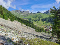
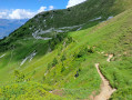
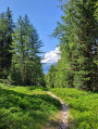
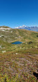
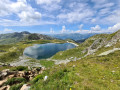
This walk takes you from meadows, where cows graze peacefully, to the fir forest overlooking the Tarentaise valley. It is a circular route that skirts around Mont Saint-Jacques. A very pleasant walk through the forest section during periods of hot weather.

Details

36327228
Creation:
Last update:
Last review:
  • Walking
    Activity: Walking
  • ↔
    Distance: 4.96 mi
  • ◔
    Average duration: 3h 55 
  • ▲
    Difficulty: Moderate

  • ⚐
    Back to start: Yes
  • ↗
    Ascent: + 1,854 ft
  • ↘
    Descent: - 1,860 ft

  • ▲
    Highest point: 7,516 ft
  • ▼
    Lowest point: 6,033 ft

Photos

Description of the walk

Park in the square to the north of the village of Belle Plagne. A covered car park is available. It is also free in summer.

(S/E) Head north, keeping to the stony track. You will reach a crossroads with several routes.

(1) Stay on the track straight ahead, then turn left off it to take the path leading to the two Arpette chalets. Turn left and continue uphill to reach the base of the Arpettes chairlift.

(2) Continue uphill and, after a short descent, reach the Col du Seuchet. Take care on this section as there are several paths and no signposting; to avoid going astray, keep heading north until you reach the Col du Seuchet.

(3) Continue along the path opposite, heading downhill and north-east, until you reach another T-junction.

(4) Take the path on the left heading north-west. Continue down a steep descent to reach the edge of the forest.

(5) Enter the forest and, at the bottom of the descent, reach the junction with the road to the hamlet of Les Frasses.

(6) Turn left here, start climbing again and walk past a developed area and a pumping station. You’ll soon come to a path junction; take the left-hand path and continue uphill until you reach a junction with several routes.

(7) Take the path on the left and continue the climb towards Belle Plagne. You’ll reach the edge of the forest.

(8) Continue on an easier climb, pass under the avalanche barriers and reach the Arpettes chairlift.

(9) Start the descent here to reach the initial junction you passed on the way up.

(1) Turn right and retrace your steps along the route you took on the way there to return to the Belle Plagne car park (S/E).

Waypoints

  1. S/E : mi 0 - alt. 6,791 ft - Belle Plagne car park
  2. 1 : mi 0.3 - alt. 7,011 ft - Crossroads at the end of the circular loop
  3. 2 : mi 0.71 - alt. 7,165 ft - Les Arpettes chairlift
  4. 3 : mi 1.12 - alt. 7,500 ft - Col du Seuchet (2286m)
  5. 4 : mi 1.42 - alt. 7,277 ft - Crossroads below the Tête des Arpettes
  6. 5 : mi 1.89 - alt. 6,660 ft - Edge of the forest
  7. 6 : mi 2.44 - alt. 6,040 ft - The hamlet of Les Frasses
  8. 7 : mi 3.09 - alt. 6,381 ft - Crossroads with several directions
  9. 8 : mi 3.74 - alt. 6,932 ft - Edge of the forest
  10. 9 : mi 4.35 - alt. 7,060 ft - Les Arpettes chairlift
  11. S/E : mi 4.96 - alt. 6,785 ft - Belle Plagne car park

Reviews and comments

4 / 5
Based on 3 reviews

Reliability of the description
4 / 5
Ease of following the route
3.7 / 5
Route interest
4.3 / 5
philippe basty
philippe basty

Overall rating : 4 / 5

Date of your route : Aug 26, 2025
Reliability of the description : ★★★★★ Very good
Ease of following the route : ★★★☆☆ Average
Route interest : ★★★★☆ Good
Very busy route : No

A beautiful route, not always well marked, but with the app and GPS you can find your way without any problems.
There were lots of marmots, and they were within reasonable distance of the camera lens.
Please do not approach them, touch them or feed them.

Machine-translated

Patav
Patav

The starting point is indeed at Belle Plagne; GPS coordinates 45°30'34.9"N / 6°42'22.6"E (or 45.509684, 6.706279 on Google Maps)

Machine-translated

Pithe
Pithe

Overall rating : 4 / 5

Date of your route : Aug 21, 2023
Reliability of the description : ★★★☆☆ Average
Ease of following the route : ★★★★☆ Good
Route interest : ★★★★★ Very good
Very busy route : Yes

The departure point is at La Plagne Cote, not at Belle Plagne

Machine-translated

Pithe
Pithe

A really lovely walk. No one on the first part of the climb. Stunning views of Mont Blanc.

Machine-translated

Patav
Patav
• Edited:

Overall rating : 4 / 5

Date of your route : Jul 31, 2023
Reliability of the description : ★★★★☆ Good
Ease of following the route : ★★★★☆ Good
Route interest : ★★★★☆ Good
Very busy route : No

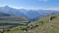
A lovely walk, particularly worth doing for the stunning view of Mont Blanc between stages (3) and (4). You’ll be walking amongst blueberries and bellflowers.
The route starts beneath the Belle Plagne chairlifts, where you may spot some marmots.
Best spots for a picnic: at point (3) or point (4).
The descent between (4) and (5) takes you over a rather unpleasant scree slope, then through the forest, which provides welcome shade but lacks views. We came across a few mountain bikers on this section.
The route isn’t signposted, but navigating with the Visiorando app is no problem at all.

Machine-translated

Other walks in the area

For more walks, use our search engine .

The GPS track and description are the property of this route's author. Please do not copy them without permission.