Discover the Montagne de l'Arc via Lac du Carroley

This hike is a longer version of the one suggested by the La Plagne Tourist Office. You will see Les Inversens and the summit of Bellecôte as you pass by the Carroley mountain and its small lake.
You will descend to Belle Plagne via the foot of Mont Saint-Jacques (2,407 m).

Details

3824895
Creation:
Last update:
Last review:
  • Walking
    Activity: Walking
  • ↔
    Distance: 7.64 km
  • ◔
    Average duration: 3h 30 
  • ▲
    Difficulty: Moderate

  • ⚐
    Back to start: Yes
  • ↗
    Ascent: + 456 m
  • ↘
    Descent: - 447 m

  • ▲
    Highest point: 2,373 m
  • ▼
    Lowest point: 2,070 m

Photos

Description of the walk

Start at the entrance to the Belle Plagne covered car park.

(S/E) Turn your back on the car park and look north, with the fire station on your right. Take a stony path that climbs above the bus stop and seems to lead towards the "Les Balcons" apartment building (6 storeys).
In fact, this stony farm track passes between two buildings and climbs towards the Col du Carroley.

(1) Leave the path towards Mont Saint-Jacques (path on the left) and follow the farm track, which now heads east towards Col du Carroley.
From this point, you can already see part of the building, the final destination of your climb.

(2) Leave the northbound logging road that leads to Col de l'Arpette or Col du Carroley
and take a new path heading south-southeast. There are no signposts at this point.

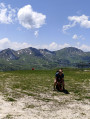
(3) Take a break at the pass to admire the view of the resort. You have reached the highest point of this hike.
Continue down the logging road towards the south to reach a hairpin bend.

(4) Move a few metres to the south-east to admire the Crête des Inversens, the Roche de Mio (partial) and the summit of Bellecôte above the Chiaupe Glacier.
Continue down the path to pass under the Crozats chairlift. 150 m further on, pass a rocky outcrop and pay attention to your right.

(5) There are no signs at this point, but a very faint path on short grass on your right takes you directly down to Lac du Carroley. The path becomes very clear 150 m further down.

(6) It is best to approach the lake by turning clockwise to enjoy the best view, particularly the reflection of Pointe du Friolin on the lake.
North of the lake, head north up the steep path to reach Col du Carroley. This turns west and flattens out (a little!) before the pass.

At Col du Carroley, another path that passes under the Salla chairlift, heading west, avoids the long, winding logging road and takes you to the foot of a huge sculpture made from parts of a ski lift. Directional sign "Mont Saint-Jacques, 0h 40". Go to the Col de l'Arpette viewpoint.

(7) At the viewpoint, enjoy the beautiful surrounding views. Then head west towards Mont Saint-Jacques (signposted 30 mins), leaving the Tête des Arpettes on your right. Arrive at the Col du Seuchet.

(8) Turn left, heading south, following the signs for "Belle Plagne - 0h 35". Pass under the Télésiège des Arpettes chairlift and walk for about 250 m.

(9) Take the path on the right heading south to pass under the Chalet de l'Arpette.

(1) Turn right and walk down the forest path to return to the Belle Plagne resort car park (S/E).

Waypoints

  1. S/E : km 0 - alt. 2,070 m - Entrance to the covered car park
  2. 1 : km 0.51 - alt. 2,137 m - Carrefour du Chalet de l'Arpette
  3. 2 : km 2.22 - alt. 2,315 m - Fork to the right
  4. 3 : km 2.67 - alt. 2,371 m - Highest point of the hike
  5. 4 : km 3.1 - alt. 2,333 m - Hairpin bend and panoramic view
  6. 5 : km 3.72 - alt. 2,281 m - Start of the trail to Lac du Carroley
  7. 6 : km 4.11 - alt. 2,187 m - Lac du Carroley
  8. 7 : km 5.21 - alt. 2,346 m - Col de l'Arpette viewpoint
  9. 8 : km 5.98 - alt. 2,286 m - To the left towards the - Col du Seuchet (2286m)
  10. 9 : km 6.93 - alt. 2,158 m - Fork, on the right
  11. S/E : km 7.64 - alt. 2,070 m - Entrance to the covered car park

Notes

The lake water can be filtered, but I refrained from doing so! All the buildings are closed in summer, so there is no water on the route.

This hike is suitable for those accustomed to elevation changes. Even though the elevation gain may seem low, the climb between (2) and (3) is a bit rough.
Others may wish to make several rest stops or shorten the hike by going directly to the Col du Carroley to see the lake. For example, go from (2) to (7), then descend towards the lake. Be prepared for the climb back up from the lake, as it is steep!

The covered car park is free during the summer season, so make the most of it!

Worth a visit

There isn't enough space to list everything you can do in La Plagne in summer (horse riding, mountain biking, swimming, etc.).

Reviews and comments

4.8 / 5
Based on 7 reviews

Reliability of the description
4.7 / 5
Ease of following the route
4.7 / 5
Route interest
4.9 / 5
JOE4217
JOE4217

Overall rating : 5 / 5

Date of your route : Aug 25, 2025
Reliability of the description : ★★★★★ Very good
Ease of following the route : ★★★★★ Very good
Route interest : ★★★★★ Very good
Very busy route : No

Superb hike, beautiful 360° views. The view of Mont Blanc is sublime on a clear day. I recommend this hike.

Machine-translated

Patrixdemex
Patrixdemex

Overall rating : 5 / 5

Date of your route : Jul 06, 2025
Reliability of the description : ★★★★★ Very good
Ease of following the route : ★★★★★ Very good
Route interest : ★★★★★ Very good
Very busy route : No

Although we are in "industrial" mountains (wide paths for maintenance of the estate and ski lifts criss-crossing the landscape), this hike is nice with the lake and the viewpoint.
It's perfect for a half-day hike.
Thanks for the route info

Machine-translated

User 15299676

Overall rating : 5 / 5

Date of your route : Jul 14, 2025
Reliability of the description : ★★★★★ Very good
Ease of following the route : ★★★★★ Very good
Route interest : ★★★★★ Very good
Very busy route : Yes

A very pleasant route with a beautiful mountain lake as the highlight.

Machine-translated

MONVOISIN MARIE
MONVOISIN MARIE

Overall rating : 4.3 / 5

Date of your route : Aug 12, 2024
Reliability of the description : ★★★★☆ Good
Ease of following the route : ★★★★☆ Good
Route interest : ★★★★★ Very good
Very busy route : No

Beautiful route, 360-degree panoramic landscape.

Do not forget to bring at least 1 litre of water.

Machine-translated

Annesodu44
Annesodu44

Overall rating : 4.3 / 5

Date of your route : Aug 08, 2023
Reliability of the description : ★★★★☆ Good
Ease of following the route : ★★★★☆ Good
Route interest : ★★★★★ Very good
Very busy route : No

The route is well marked on the app but very poorly marked on the trail (keep a close eye on your phone at intersections, as we almost took a wrong turn several times).
Pay particular attention to the path leading to the lake, as we didn't see it and I had to use the app's compass to figure out which way to go. Also, be careful at the lake because the route takes you to the left of the lake and it's really difficult (for novices like us, don't be afraid of heights because the path at the lake is very narrow and high (putting one foot in front of the other is already almost impossible...). Take the path on the right, which leads to the same place in the end but looks much safer.

Otherwise, this route is really great. We loved the view and the peace and quiet. We were well guided by Visorando (as there were no other signs, or at least we didn't see any).

Thank you 😌

Machine-translated

serrou14
serrou14

Overall rating : 5 / 5

Date of your route : Jul 12, 2023
Reliability of the description : ★★★★★ Very good
Ease of following the route : ★★★★★ Very good
Route interest : ★★★★★ Very good
Very busy route : No

Thank you for this route, which allows us to discover this lake and these landscapes. It's a shame that there are so many stony forest tracks in La Plagne.

Machine-translated

BARET André
BARET André

Overall rating : 4.7 / 5

Date of your route : Aug 20, 2021
Reliability of the description : ★★★★★ Very good
Ease of following the route : ★★★★★ Very good
Route interest : ★★★★☆ Good
Very busy route : No

Beautiful hike (provided you "forget" the numerous winter sports facilities).
Well-marked route. We extended the hike by climbing Mont Saint Jacques: from the Col du Seuchet, continue towards the ridge of Mont Saint Jacques and climb up a good path to the summit (beautiful views, cross and small chapel). Descend via a path that winds through the avalanche barriers (black dots on the map) and then via an old moraine to rejoin the descent route at an altitude of 2,159 metres (8 on the description).

Machine-translated

Other walks in the area

For more walks, use our search engine .

The GPS track and description are the property of this route's author. Please do not copy them without permission.