Country:

 City:
City:


The start is at the information sign on Rue des Raisins. You can park in the square beneath the sign, or on Rue des Suisses. Alternatively, there is a car park in front of the church, less than a 5-minute walk away.
(S/E) Head due south along Rue des Raisins to the end of the road, then take the small path leading uphill to the right. This path is sometimes quite overgrown, but that is the only difficulty on this route. Just before the junction with the road, take the path on the right and then, at the next junction, the path leading downhill to the right. At the end of this path, go round the back of the church and you’ll come out onto Rue du Bois.
(1) Turn left, ignore a street on the left and continue along Rue du Bois to the end. It continues through the woods, reaching a junction after a wide left-hand bend.
(2) Take the path on the right; at the next Fork in the road, keep left. Then walk past the chalet, following the path on the right for about 200 m until you reach a crossroads.
(3) Several trees are marked with white paint; turn right, following the Red Ring signposts. Cross a forest track and continue straight on towards the west until you reach a junction with a dirt track.
(4) Follow this track to the left as it climbs, then, at the next junction, go straight on, following the sign for ‘Chemin des Carrières’. Continue following the Red Ring markings until you reach the next junction.
(5) Pass the return path on your right, as well as the path a few metres further on to the left, heading east. Take the path on the left heading south-east. Carry on straight ahead, then, at the Fork in the road, keep to the right to reach the quarry. Walk alongside it, then follow the path which moves away from and then back towards the cliff. The path eventually reaches a junction with some benches.
(6) Go round them on the right to take the small path, still following the Red Ring markings. At the next junction, turn onto the path on the right and continue due north.
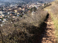
Along the way, veer slightly to the right to enjoy a magnificent view of the valley – not to be missed.
(7) The site also has a small picnic area. Then return to the path and follow it straight on until you reach the junction you passed on the way there.
(5) Turn right, as if starting a second loop, but a few metres further on, take the first path that descends to the left and leads to a junction some 300 metres further on.
(8) Turn right onto the path leading downhill. Join a wider path and follow it straight on at every junction. Pass close to the fitness trail and arrive at a small car park at a place called Egten.
(9) After the car park, take the road on the left marked with a Red Diamond. Follow this road due north and enter the village. Continue straight on until you reach Rue des Raisins on your left and your car park (S/E).



 Visorando Member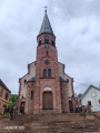
 Easy
Easy 

 Tourist office