Crête des Rortres, Pic Chauve, Grotte du Pertuis, Ravin de la Mèque circular loop

From La Roche des Arnauds, this route takes you up Pic Chauve via the Crête des Rortres, then down via the Col des Sérigons, with a stop at the Grotte du Pertuis (bring a torch) before returning via the Ravin de la Mèque.
Apart from the section along the ridge, the route runs mainly through woodland, with a few clearings offering views of the landscape. Pic Chauve overlooks the upper valley of the Petit Buëch and offers beautiful panoramic views.

Details

94149557
Creation:
Last update:
Last review:
  • Walking
    Activity: Walking
  • ↔
    Distance: 6.88 mi
  • ◔
    Average duration: 5h 40 
  • ▲
    Difficulty: Moderate

  • ⚐
    Back to start: Yes
  • ↗
    Ascent: + 2,838 ft
  • ↘
    Descent: - 2,825 ft

  • ▲
    Highest point: 5,791 ft
  • ▼
    Lowest point: 3,074 ft

Photos

Description of the walk

On the D994road between Veynes and Gap, at La Plaine ( La Roche-des-Arnauds neighbourhood), take the Chemin des Barrets (small white sign indicating the climbing site). After about 500 m,turn left at the junction with the Route de la Plaine (wooden signpost opposite the gate). Walk less than 200 m, thenturn right to reach the car park at the climbing site (end of the road).

(S/E) Follow the path up towards the Rif de l’Arc, heading north, and cross it a few metres further on.

(1) Turn right towards the climbing site, heading north, then climb the embankment via a footpath to reach the platform at the base of the rocky outcrop.

(2) Go round the cliff to the right, heading down towards the embankment, heading east. Cross the stream then climb up onto the embankment, heading north, until you reach a track at a hairpin bend.

(3) Take the path on the left to cross the stream again, heading north-west. Climb through the woodland to the junction.

(4) Turn right, heading north, onto a steep path (a climb of about 300 m over a short distance) until you reach the Matacharre Forest Road.

(5) Turn left onto the track, heading south-west, until you reach a hairpin bend.

(6) Continue along the path straight ahead, heading south, until you reach the end.

(7) Take the right-hand hairpin bend onto the path that climbs north-westwards until you rejoin the Matacharre Forest Road.

(8) Turn left onto the track, heading north-west. Pass the first hairpin bend to the left, then reach a second hairpin bend to the right.

(9) Continue along the track to the left, heading south. Look out for the cairn on the right marking a path leading up to the ridge, just before a sharp bend in the track.

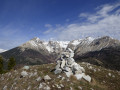
(10) Take this path on the right, heading north-west, to climb the Crête des Rortres. Reach the Pic Chauve and its summit cairn. Enjoy the beautiful 360° panorama.

(11) Turn left and follow the edge of the trees, heading west, to reach the Tête Plumée via a poorly marked path. The path then becomes clearer, but the descent becomes very steep down to the Col des Sérigons.

(12) Turn left, heading south, to descend towards “La Plaine – Montmaur” along the yellow-marked path. You’ll reach a wide forest track.

(13) Turn left, heading north, then take a wide right-hand bend. You will reach a junction with a path coming from the right.

(14) Continue straight ahead on the track, which descends gently until it curves slightly to the right. Look out for the cairns marking the entrance to the cave, or, if these are not visible, the line of five large fir trees on the slope above.

(15) Climb up to the left along the slope of mixed earth and rocks, right next to a small fir tree at the edge of the track. The first ten metres are steep, then the climb becomes easier through the branches and broom. Reach the entrance to the cave by zigzagging a few times.
Caution: the rocks are slippery inside the first chamber
. The cave can be explored without difficulty as far as the ‘cauliflower’ formation at the bottom of the second chamber. Beyond this point, the floor becomes very slippery and exploration requires a rope (final obstruction at around –35 m).
Turn back and head up the track.

(14) Turn left onto the track, heading west, and descend gently. Pass a left-hand bend, then after about 120 m, leave the track for a path on the left, through the woodland and marked in yellow. Reach the Ravin de la Mèque via a series of small hairpin bends, then descend due south. Ignore the various offshoots on the left (path crossing the torrent, old timber skid trails). Reach a junction with a signpost.

(16) Turn left to cross the valley floor in a bend. Continue the descent, heading south-east, to the streams at a place known as La Mèque.

(17) Carry on straight ahead, heading south-east, ignoring the path leading to the campsite on the right. Join the access paths to the climbing site and take the track on the right, heading south.

(1) Head down towards the car park, still heading south, to return to the starting point (S/E).

Waypoints

  1. S/E : mi 0 - alt. 3,074 ft - Car park at the Plaine climbing site
  2. 1 : mi 0.03 - alt. 3,077 ft - Junction with climbing routes
  3. 2 : mi 0.13 - alt. 3,127 ft - La Plaine climbing site
  4. 3 : mi 0.34 - alt. 3,192 ft - Hairpin bend on the Manjon track
  5. 4 : mi 0.43 - alt. 3,251 ft - Trail junction beneath the Roc de Jarjayette
  6. 5 : mi 1.28 - alt. 4,012 ft - Matacharre forest track
  7. 6 : mi 1.44 - alt. 4,052 ft - Trails cross at the hairpin bend
  8. 7 : mi 1.85 - alt. 4,170 ft - End of the wide path
  9. 8 : mi 2.33 - alt. 4,426 ft - Matacharre forest track (hairpin bend)
  10. 9 : mi 2.6 - alt. 4,528 ft - Trail junction (hairpin bend on the right)
  11. 10 : mi 2.97 - alt. 4,600 ft - Crête des Rortres
  12. 11 : mi 3.81 - alt. 5,791 ft - Pic Chauve
  13. 12 : mi 4.15 - alt. 5,262 ft - Signpost no. 554 - Col des Sérigons (1606m)
  14. 13 : mi 4.53 - alt. 4,888 ft - Tête de Vène forest track
  15. 14 : mi 4.86 - alt. 4,708 ft - Junction with a path
  16. 15 : mi 5.03 - alt. 4,652 ft - Pertuis Cave
  17. 16 : mi 5.77 - alt. 4,134 ft - Ravin de la Mèque (signpost no. 552)
  18. 17 : mi 6.21 - alt. 3,694 ft - La Mèque
  19. S/E : mi 6.88 - alt. 3,074 ft - Car park at the Plaine climbing site

Notes

There is no source of drinking water along the route, despite the presence of a spring in the Ravin de la Mèque, between waypoints (14) and (16).

It is possible to take the forest road rather than the footpath between points (6) and (8).

This route should be avoided in wet weather due to rocky sections, some steep slopes and slippery undergrowth. Crossing the Rif de l’Arc can be tricky depending on the water level.

Access to the cave is steep and can be tricky at times, particularly on the ascent. Bring a torch for exploring the cave. The time given for the walk does not include the time spent inside the cave.

A mostly shaded walk, pleasant in summer, with some lovely views over the valley.

Worth a visit

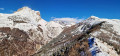
The Crête des Rortes forms a distinct ridge line linking the areas of the Col des Sérigons, the Tête Plumée and the Pic Chauve. Fairly grassy and open in its upper reaches, it offers beautiful panoramic views of the Dévoluy massif (Montagne de Bure) and the Petit Buëch valley.

Pic Chauve (1,771 m) is easily recognisable as the neighbouring ridges are more wooded, particularly the Tête de Vène. Its summit offers a remarkable 360° view: Dévoluy, Pic de Bure, Céüse and the Buëch valley.

The Tête Plumée (1,663 m) is a wooded hilltop situated between the Col des Sérigons and the Pic Chauve.

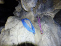
The Grotte du Pertuis is a natural cave situated at La Roche-des-Arnauds, above the Ravin de la Mèque. This modestly sized karst cave is carved into the limestone of the Dévoluy massif. Its entrance is clearly visible, but a torch is required to explore it. Please be aware: the cave may occasionally be home to bats (pipistrelles and common pipistrelles, depending on the season). It is important not to disturb them, particularly in winter (hibernation) and in summer (when they give birth).

The Ravin de la Mèque, a steep-sided gorge that is wilder than the ridge, offers a mix of scree, forest tracks and wooded slopes.

Other walks in the area

For more walks, use our search engine .

The GPS track and description are the property of this route's author. Please do not copy them without permission.